Trail Canoe - kayak Saint-Maurice - Sophie & Bastof - Descente Allier le 15:08/24 - Photo

Sophie & Bastof - Descente Allier le 15:08/24

© OpenStreetMap contributors
Length
Length
22 km
Max alt
Max alt
347 m
Uphill gradient
Uphill gradient
131 m
Km-Effort
Km-Effort  
24 km
Min alt
Min alt
305 m
Downhill gradient
Downhill gradient
148 m
Boucle
Boucle
No
Creation date :
2024-08-15 08:46:39.0
Updated on :
2024-08-15 14:46:14.357

(0 Reviews)

Canoe - kayak
Canoe - kayak
5h58
Difficulty : Unknown

Scan this QR Code to open this trail in the SityTrail application

FREE GPS app for hiking

Logo SityTrail SityTrail

IGN / Geographical institutes

Download SityTrail from the App Store Download SityTrail from Google Play

Logo SityTrail SityTrail World

The world is yours!

Download SityTrail from the App Store Download SityTrail from Google Play Download SityTrail on Huawei AppGallery

About

Trail Canoe - kayak of 22 km to be discovered at Auvergne-Rhône-Alpes, Puy-de-Dôme, Saint-Maurice. This trail is proposed by SophieChris.

Description

Sophie & Bastof - Descente Allier le 15/08/24

Elevation profile

Positioning

Country:
France
Region :
Auvergne-Rhône-Alpes
Department/Province :
Puy-de-Dôme
Municipality :
Saint-Maurice
Location:
Unknown
Start:(UTM)
517305 ; 5056932 (31T) N.

Trails nearby

Trail Walking Montpeyroux - Montpeyroux_Arkose - Photo
Walking
GUIDE
jagarnier

Walking

Easy
(1)
Montpeyroux, Auvergne-Rhône-Alpes, Puy-de-Dôme, France
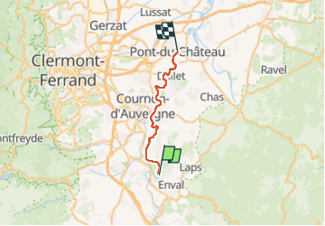
8.6 km | 11.2 km-effort
2h 30min
Yes
Trail Walking Vic-le-Comte - Vic_le_Comte_Bassin_2 - Photo
Walking
GUIDE
jagarnier

Walking

Medium
(1)
Vic-le-Comte, Auvergne-Rhône-Alpes, Puy-de-Dôme, France
12.5 km | 16.6 km-effort
3h 45min
Yes
Trail Walking Authezat - Authezat Horaire - Photo
Walking
guy63

Walking

Medium
(1)
Authezat, Auvergne-Rhône-Alpes, Puy-de-Dôme, France
7.4 km | 8.6 km-effort
2h 45min
Yes
Trail Walking Parent - Parent_Montpeyroux - Photo
Walking
GUIDE
jagarnier

Walking

Medium
(1)
Parent, Auvergne-Rhône-Alpes, Puy-de-Dôme, France
9.8 km | 13.4 km-effort
2h 45min
Yes
Trail Walking Vic-le-Comte - Entre vignes et comté - Photo
Walking
tracegps

Walking

Medium
(1)
Vic-le-Comte, Auvergne-Rhône-Alpes, Puy-de-Dôme, France
8.6 km | 10.8 km-effort
2h 30min
Yes
Trail On foot Montpeyroux - Montpeyroux - Photo
On foot
GUIDE+

On foot

Easy
Montpeyroux, Auvergne-Rhône-Alpes, Puy-de-Dôme, France
3.9 km | 5.3 km-effort
1h 12min
No
Trail On foot Authezat - Sur le Chemin de l'Arkose - Photo
On foot
GUIDE+

On foot

Easy
Authezat, Auvergne-Rhône-Alpes, Puy-de-Dôme, France
8.7 km | 11.2 km-effort
2h 33min
Yes
Trail On foot Authezat - Les Forts de la Sauvetat - Photo
On foot
GUIDE+

On foot

Easy
Authezat, Auvergne-Rhône-Alpes, Puy-de-Dôme, France
7.1 km | 8.3 km-effort
1h 52min
No
Trail On foot Veyre-Monton - Le Puy de Corent - Photo
On foot
GUIDE+

On foot

Easy
Veyre-Monton, Auvergne-Rhône-Alpes, Puy-de-Dôme, France
5.8 km | 8.3 km-effort
1h 52min
Yes


Close
My subscriptions