![](/images/other/stat-length.png)
![Trail Walking Malmedy - Malmedy - Bernister - Burnenville - Photo](https://media.geolcdn.com/t/1900/400/d66b3b4b-66a9-40d9-9348-1acdf7b699fc.jpg&format=pjpeg&maxdim=2)
Malmedy - Bernister - Burnenville
Je vous emmène sur mes chemins
Par Mumu.larandonneuse
![Length](/images/other/stat-length.png)
Length
9.3 km
![Max alt](https://static1.geolcdn.com/siteimages/upload/files/1508320355ic_sort_altitude_max_24dp.png)
Max alt
501 m
![Uphill gradient](https://static1.geolcdn.com/siteimages/upload/files/1508320355ic_sort_den_pos_24dp.png)
Uphill gradient
332 m
![Km-Effort](/images/other/stat-length.png)
Km-Effort
13.8 km
![Min alt](https://static1.geolcdn.com/siteimages/upload/files/1508320355ic_sort_altitude_min_24dp.png)
Min alt
333 m
![Downhill gradient](https://static1.geolcdn.com/siteimages/upload/files/1508320355ic_sort_den_neg_24dp.png)
Downhill gradient
337 m
![Boucle](https://static1.geolcdn.com/siteimages/upload/files/16400158638029165_repeat_loop_refresh_sync_direction_icon.png)
Boucle
Yes
Creation date :
2024-08-15 08:53:31.019
Updated on :
2024-08-15 14:37:37.007
![Walking](https://static1.geolcdn.com/sitytour/trail-icons/101.png)
2h19
Difficulty : Medium
![Scan this QR Code to open this trail in the SityTrail application](https://capi.geolives.com/qq0zvz2zws4bq2lad0pu/sitytour/trails/4156185/qr.png?size=200)
FREE GPS app for hiking
About
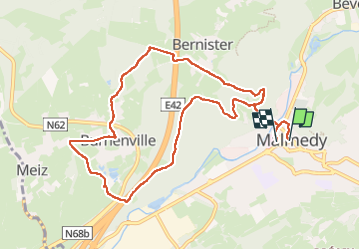
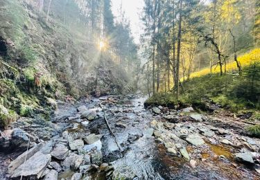
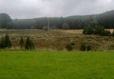
Trail Walking of 9.3 km to be discovered at Wallonia, Liège, Malmedy. This trail is proposed by Je vous emmène sur mes chemins .
Description
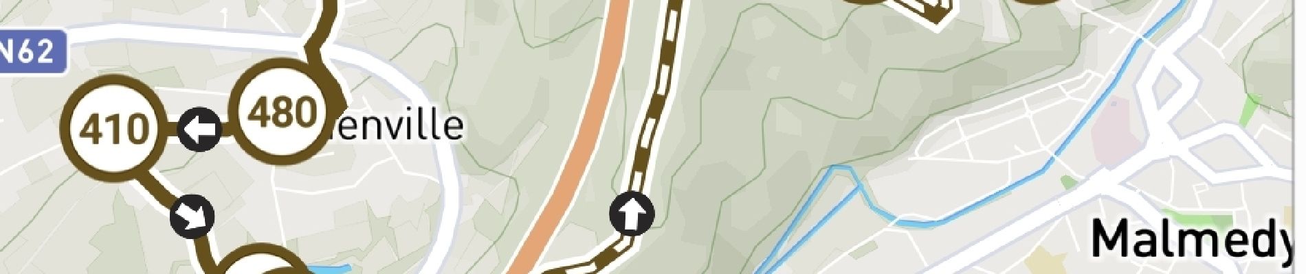
Un parcours basé sur une création de l'app NodeMapp (points-noeuds virtuels en Wallonie)
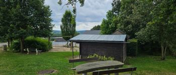
Positioning
Country:
Belgium
Region :
Wallonia
Department/Province :
Liège
Municipality :
Malmedy
Location:
Unknown
Start:(Dec)
Start:(UTM)
288860 ; 5590272 (32U) N.
Comments
Trails nearby
![Trail Walking Malmedy - RB-Lg-31_Malmedy - Photo](https://media.geolcdn.com/t/375/260/ext.jpg?maxdim=2&url=https%3A%2F%2Fservices.sitytrail.com%2FGeolivesWS%2FDownloadMedia.ashx%3FTrailID%3D402114%26Media%3D216d2e53-3b66-4632-8b4d-0cea30889665.jpg)
![Walking Walking](https://static1.geolcdn.com/sitytour/trail-icons/101.png)
![Trail Walking Malmedy - Le trôs Maret - Photo](https://media.geolcdn.com/t/375/260/97b4be7b-87c1-46c9-b673-d6e164fd84f1.jpg&format=jpg&maxdim=2)
![Walking Walking](https://static1.geolcdn.com/sitytour/trail-icons/101.png)
Le trôs Maret
Walking
Medium
(14)
Malmedy,
Wallonia,
Liège,
Belgium
![](/images/other/stat-length.png)
7.3 km | 10.1 km-effort
2h 11min
![](https://static1.geolcdn.com/siteimages/upload/files/16400158638029165_repeat_loop_refresh_sync_direction_icon.png)
Yes
![Trail Walking Malmedy - La petite vallée sauvage du Trôs Marets - Photo](https://media.geolcdn.com/t/375/260/ext.jpg?maxdim=2&url=https%3A%2F%2Fstatic1.geolcdn.com%2Fsiteimages%2Fupload%2Ffiles%2F1553511878bg_sport_marche.png)
![Walking Walking](https://static1.geolcdn.com/sitytour/trail-icons/101.png)
La petite vallée sauvage du Trôs Marets
Walking
Medium
(8)
Malmedy,
Wallonia,
Liège,
Belgium
![](/images/other/stat-length.png)
9.1 km | 12 km-effort
2h 37min
![](https://static1.geolcdn.com/siteimages/upload/files/16400158638029165_repeat_loop_refresh_sync_direction_icon.png)
Yes
![Trail Walking Malmedy - Malmedy - Baugnez - Photo](https://media.geolcdn.com/t/375/260/a34fa6e8-977c-4cba-8883-b5a7429035f5.jpg&format=jpg&maxdim=2)
![Walking Walking](https://static1.geolcdn.com/sitytour/trail-icons/101.png)
Malmedy - Baugnez
Walking
Medium
(1)
Malmedy,
Wallonia,
Liège,
Belgium
![](/images/other/stat-length.png)
14.8 km | 18.9 km-effort
3h 15min
![](https://static1.geolcdn.com/siteimages/upload/files/16400158638029165_repeat_loop_refresh_sync_direction_icon.png)
Yes
![Trail Walking Malmedy - 2021-10-22_19h44m15_1102 - Photo](https://media.geolcdn.com/t/375/260/f624bfad-0543-4f87-8b2e-a4874ba371b1.jpg&format=jpg&maxdim=2)
![Walking Walking](https://static1.geolcdn.com/sitytour/trail-icons/101.png)
2021-10-22_19h44m15_1102
Walking
Medium
(2)
Malmedy,
Wallonia,
Liège,
Belgium
![](/images/other/stat-length.png)
15.2 km | 21 km-effort
4h 41min
![](https://static1.geolcdn.com/siteimages/upload/files/16400158638029165_repeat_loop_refresh_sync_direction_icon.png)
Yes
![Trail Walking Malmedy - ferme libert tro maret - Photo](https://media.geolcdn.com/t/375/260/ext.jpg?maxdim=2&url=https%3A%2F%2Fservices.sitytrail.com%2FGeolivesWS%2FDownloadMedia.ashx%3FTrailID%3D202740%26Media%3D20130704170612.jpeg)
![Walking Walking](https://static1.geolcdn.com/sitytour/trail-icons/101.png)
ferme libert tro maret
Walking
Medium
(1)
Malmedy,
Wallonia,
Liège,
Belgium
![](/images/other/stat-length.png)
5.5 km | 7.4 km-effort
1h 35min
![](https://static1.geolcdn.com/siteimages/upload/files/16400158638029165_repeat_loop_refresh_sync_direction_icon.png)
Yes
![Trail Walking Malmedy - RB-LG-09 - Sur les hauteurs dominant la haute vallée de l’Amblève et la Warche - Photo](https://media.geolcdn.com/t/375/260/ext.jpg?maxdim=2&url=https%3A%2F%2Fservices.sitytrail.com%2FGeolivesWS%2FDownloadMedia.ashx%3FTrailID%3D179567%26Media%3D798cfc5d-29e8-4b87-852c-cc68a99be049.jpg)
![Walking Walking](https://static1.geolcdn.com/sitytour/trail-icons/101.png)
RB-LG-09 - Sur les hauteurs dominant la haute vallée de l’Amblève et la Warche
Walking
Medium
(4)
Malmedy,
Wallonia,
Liège,
Belgium
![](/images/other/stat-length.png)
26 km | 34 km-effort
7h 12min
![](https://static1.geolcdn.com/siteimages/upload/files/16400158638029165_repeat_loop_refresh_sync_direction_icon.png)
Yes
![Trail Walking Malmedy - Balade de rêve 4 - Le canyon des Trôs Marets - Photo](https://media.geolcdn.com/t/375/260/00b47c34-b42a-48f8-a2cb-09ee85e4736c.jpg&format=jpg&maxdim=2)
![Walking Walking](https://static1.geolcdn.com/sitytour/trail-icons/101.png)
Balade de rêve 4 - Le canyon des Trôs Marets
Walking
Medium
(2)
Malmedy,
Wallonia,
Liège,
Belgium
![](/images/other/stat-length.png)
5 km | 6.8 km-effort
1h 32min
![](https://static1.geolcdn.com/siteimages/upload/files/16400158638029165_repeat_loop_refresh_sync_direction_icon.png)
Yes
![Trail Walking Malmedy - xhoffraix . cheneux . moulin et cascade bayehon . vieux chêne . longfaye . xhoffraix - Photo](https://media.geolcdn.com/t/375/260/d03e0c64-90c0-4767-998e-9e240f1eb32e.jpg&format=jpg&maxdim=2)
![Walking Walking](https://static1.geolcdn.com/sitytour/trail-icons/101.png)
xhoffraix . cheneux . moulin et cascade bayehon . vieux chêne . longfaye . xh...
Walking
Easy
(2)
Malmedy,
Wallonia,
Liège,
Belgium
![](/images/other/stat-length.png)
12.3 km | 15.9 km-effort
3h 7min
![](https://static1.geolcdn.com/siteimages/upload/files/16400158638029165_repeat_loop_refresh_sync_direction_icon.png)
Yes