15 km | 18.4 km-effort
ST lubin (randonnée LMA)
danchal
User
Length
16.4 km
Max alt
131 m
Uphill gradient
247 m
Km-Effort
19.7 km
Min alt
77 m
Downhill gradient
246 m
Boucle
Yes
Creation date :
2024-08-14 15:01:34.273
Updated on :
2024-08-14 15:04:06.316
4h28
Difficulty : Very difficult
FREE GPS app for hiking
About
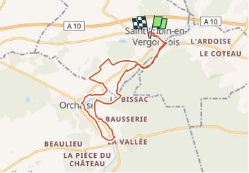
Trail Walking of 16.4 km to be discovered at Centre-Loire Valley, Loir-et-Cher, Saint-Lubin-en-Vergonnois. This trail is proposed by danchal.
Description
marche soutenue, sans difficulté
Positioning
Country:
France
Region :
Centre-Loire Valley
Department/Province :
Loir-et-Cher
Municipality :
Saint-Lubin-en-Vergonnois
Location:
Unknown
Start:(Dec)
Start:(UTM)
367333 ; 5274717 (31T) N.
Comments
Trails nearby
Circuit n°4 de Moulineuf
Walking
Medium
(1)
Valencisse,
Centre-Loire Valley,
Loir-et-Cher,
France
3h 45min
Yes
Fossé
Walking
Medium
Fossé,
Centre-Loire Valley,
Loir-et-Cher,
France
9.1 km | 10.3 km-effort
2h 20min
Yes
Saint-Sulpice-de-Pommeray
Walking
Medium
Saint-Sulpice-de-Pommeray,
Centre-Loire Valley,
Loir-et-Cher,
France
24 km | 29 km-effort
8h 41min
Yes
Circuit n°3 de Molineuf
Walking
Medium
Valencisse,
Centre-Loire Valley,
Loir-et-Cher,
France
12.3 km | 14.6 km-effort
3h 0min
Yes
Circuit n°2 de Molineuf
Walking
Medium
Valencisse,
Centre-Loire Valley,
Loir-et-Cher,
France
9 km | 11.6 km-effort
2h 45min
Yes
Circuit n°1 de Molineuf
Walking
Difficult
Valencisse,
Centre-Loire Valley,
Loir-et-Cher,
France
16.9 km | 20 km-effort
4h 15min
Yes
Molineuf - Carmel 20-03-2023
Walking
Easy
Valencisse,
Centre-Loire Valley,
Loir-et-Cher,
France
8.3 km | 10.1 km-effort
2h 15min
Yes
Molineuf-Coûtant-Orchaise 2 10.04.21
Walking
Easy
Valencisse,
Centre-Loire Valley,
Loir-et-Cher,
France
14.3 km | 17.9 km-effort
2h 50min
Yes
Randonnée de Saint Notaire, reconnaissance BBR
Walking
Very easy
Saint-Bohaire,
Centre-Loire Valley,
Loir-et-Cher,
France
14.5 km | 16.7 km-effort
3h 2min
Yes