Trail Walking Château-Thierry - Les vignes Castelles - parcours B - Photo

Les vignes Castelles - parcours B

 VANDERPUTTENMi
VANDERPUTTENMi

User GUIDE

© OpenStreetMap contributors
Length
Length
11.1 km
Max alt
Max alt
190 m
Uphill gradient
Uphill gradient
251 m
Km-Effort
Km-Effort  
14.5 km
Min alt
Min alt
57 m
Downhill gradient
Downhill gradient
251 m
Boucle
Boucle
Yes
Creation date :
2024-08-13 11:40:22.04
Updated on :
2024-08-13 12:09:30.668

(0 Reviews)

Walking
Walking
3h17
Difficulty : Difficult

Scan this QR Code to open this trail in the SityTrail application

FREE GPS app for hiking

Logo SityTrail SityTrail

IGN / Geographical institutes

Download SityTrail from the App Store Download SityTrail from Google Play

Logo SityTrail SityTrail World

The world is yours!

Download SityTrail from the App Store Download SityTrail from Google Play Download SityTrail on Huawei AppGallery

About

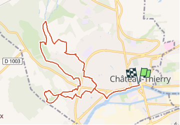
Trail Walking of 11.1 km to be discovered at Hauts-de-France, Aisne, Château-Thierry. This trail is proposed by VANDERPUTTENMi.

Description

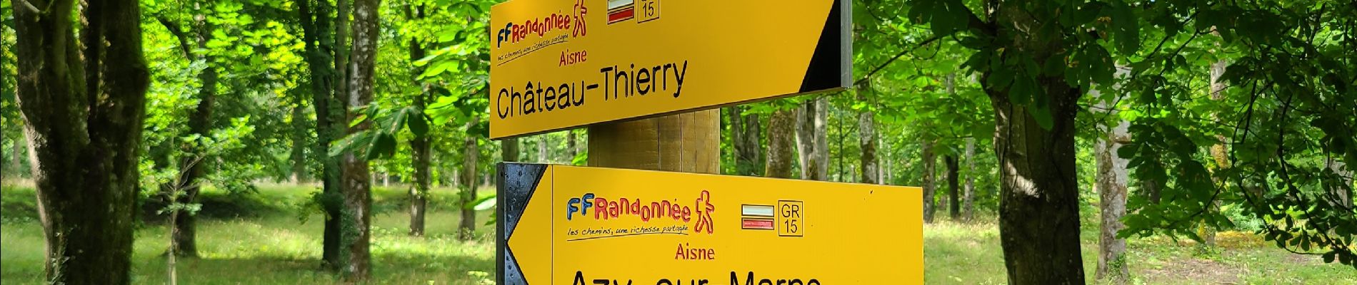
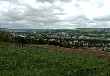
Depuis la Maison du Tourisme on suit la trace rouge et blanche du GR 15 "Vallée de la Marne" jusqu'au Monument Américain et son point de vue sur la ville, on passe par "le Marais" et sa biodiversité pour remonter au dessus de Vincelles et ses vignes et aborder une autre vue de cette vallée de la Marne et on reviens par les jardins du Patis St Martin.

Elevation profile

Photos

Positioning

Country:
France
Region :
Hauts-de-France
Department/Province :
Aisne
Municipality :
Château-Thierry
Location:
Unknown
Start:(UTM)
529379 ; 5432478 (31U) N.

Trails nearby

Trail Walking Château-Thierry - Le chemin de St Colomban en IDF Etape 1 Chateau Thierry - Nanteuil sur Marne - Photo
Walking
GUIDE
chessyca

Walking

Very difficult
Château-Thierry, Hauts-de-France, Aisne, France
35 km | 44 km-effort
7h 12min
No
Trail Walking Château-Thierry - Les Vignes Castelles trace du 28-04-2024 - Photo
Walking
GUIDE
VANDERPUTTENMi

Walking

Difficult
Château-Thierry, Hauts-de-France, Aisne, France
12.6 km | 16.4 km-effort
3h 43min
Yes
Trail Walking Château-Thierry - Les vignes Castelles - version 8 km - Photo
Walking
GUIDE
VANDERPUTTENMi

Walking

Medium
Château-Thierry, Hauts-de-France, Aisne, France
8.2 km | 10.3 km-effort
2h 20min
Yes
Trail Walking Chierry - Chierry - Photo
Walking
GUIDE
VANDERPUTTENMi

Walking

Very easy
(1)
Chierry, Hauts-de-France, Aisne, France
10.8 km | 13.3 km-effort
3h 1min
Yes
Trail Walking Nesles-la-Montagne - Nesles la Montagne du 02/06/2020 - Photo
Walking
GUIDE
VANDERPUTTENMi

Walking

Very easy
Nesles-la-Montagne, Hauts-de-France, Aisne, France
8.6 km | 11.1 km-effort
1h 45min
Yes
Trail Mountain bike Château-Thierry - Château / Mont St Père / Azy / Château - Photo
Mountain bike
GUIDE
VANDERPUTTENMi

Mountain bike

Very easy
Château-Thierry, Hauts-de-France, Aisne, France
33 km | 35 km-effort
1h 40min
Yes
Trail Walking Château-Thierry - Château - Aulnois - Château du 26/05/2020 - Photo
Walking
GUIDE
VANDERPUTTENMi

Walking

Very easy
Château-Thierry, Hauts-de-France, Aisne, France
9.2 km | 11.1 km-effort
2h 4min
Yes
Trail Running Verdilly - Verdilly Balcons de la Marne  - Photo
Running
nicochproun

Running

Medium
(1)
Verdilly, Hauts-de-France, Aisne, France
32 km | 41 km-effort
Unknown
Yes
Trail Mountain bike Château-Thierry - BRIC 2024 reconnaissance - Photo
Mountain bike
GUIDE
VANDERPUTTENMi

Mountain bike

Easy
Château-Thierry, Hauts-de-France, Aisne, France
11 km | 12.2 km-effort
54min
Yes


Close
My subscriptions