Trail Walking Rueil-Malmaison - Rueil Ville, château, Cucufa-Seine - Photo

Rueil Ville, château, Cucufa-Seine

 FRayssac
FRayssac

User

© OpenStreetMap contributors
Length
Length
9.6 km
Max alt
Max alt
104 m
Uphill gradient
Uphill gradient
128 m
Km-Effort
Km-Effort  
11.3 km
Min alt
Min alt
16 m
Downhill gradient
Downhill gradient
131 m
Boucle
Boucle
Yes
Creation date :
2024-08-11 07:21:29.213
Updated on :
2024-08-11 09:31:53.407

(0 Reviews)

Walking
Walking
2h05
Difficulty : Medium

Scan this QR Code to open this trail in the SityTrail application

FREE GPS app for hiking

Logo SityTrail SityTrail

IGN / Geographical institutes

Download SityTrail from the App Store Download SityTrail from Google Play

Logo SityTrail SityTrail World

The world is yours!

Download SityTrail from the App Store Download SityTrail from Google Play Download SityTrail on Huawei AppGallery

About

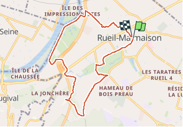
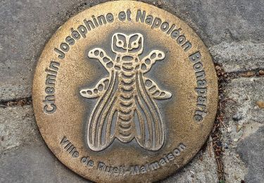
Trail Walking of 9.6 km to be discovered at Ile-de-France, Hauts-de-Seine, Rueil-Malmaison. This trail is proposed by FRayssac.

Description

Rando tranquille depuis Rueil-Malmaison mais chaussures confortables requises. Possible d'allonger de 5 km environ dans le bois. Les variantes ne manquent pas. Attention aux horaires pour les parcs de Bois préau et parc de l'amitié ( contournement possible si c'est fermé)

Elevation profile

Photos

Positioning

Country:
France
Region :
Ile-de-France
Department/Province :
Hauts-de-Seine
Municipality :
Rueil-Malmaison
Location:
Unknown
Start:(UTM)
440004 ; 5414180 (31U) N.

Trails nearby

Trail Walking Rueil-Malmaison - St Germain en Laye - Rueil Malmaison 28 km Inversee - Photo
Walking
GUIDE
chessyca

Walking

Easy
(1)
Rueil-Malmaison, Ile-de-France, Hauts-de-Seine, France
28 km | 32 km-effort
6h 0min
No
Trail Walking Bougival - Bougival-Saint-cucufa reel - Photo
Walking
perlimpinpin59

Walking

(1)
Bougival, Ile-de-France, Yvelines, France
7.7 km | 10.3 km-effort
2h 29min
Yes
Trail Walking Boulogne-Billancourt - Parc de St Cloud et forêt de Fausses Reposes - Photo
Walking
tracegps

Walking

Medium
(1)
Boulogne-Billancourt, Ile-de-France, Hauts-de-Seine, France
18.2 km | 23 km-effort
4h 30min
No
Trail On foot Boulogne-Billancourt - Boulogne -  Marne la Coquette - Ville d'Avray - Meudon - Photo
On foot
GUIDE
chessyca

On foot

Difficult
Boulogne-Billancourt, Ile-de-France, Hauts-de-Seine, France
29 km | 36 km-effort
8h 9min
No
Trail On foot Rueil-Malmaison - SityTrail - 3850997 - rando-chatou (1) - Photo
On foot
GUIDE
chessyca

On foot

Medium
Rueil-Malmaison, Ile-de-France, Hauts-de-Seine, France
32 km | 37 km-effort
8h 22min
No
Trail Walking Rueil-Malmaison - De Rueil Malmaison aux Serres d'Auteuil via Suresnes - Photo
Walking
GUIDE
chessyca

Walking

Very easy
Rueil-Malmaison, Ile-de-France, Hauts-de-Seine, France
22 km | 26 km-effort
5h 3min
No
Trail Walking Rueil-Malmaison - Domaine Malmaison - Cité jardin Suresnes - Boulogne - Serres d'Auteuil - Photo
Walking
GUIDE
chessyca

Walking

Easy
Rueil-Malmaison, Ile-de-France, Hauts-de-Seine, France
22 km | 27 km-effort
4h 54min
No
Trail Walking Rueil-Malmaison - De rueil Malmaison à St Germain en Laye - Photo
Walking
GUIDE
chessyca

Walking

Medium
Rueil-Malmaison, Ile-de-France, Hauts-de-Seine, France
28 km | 32 km-effort
5h 56min
No
Trail Walking Vaucresson - GRP CV-IDF 2023 - Photo
Walking
clalaur

Walking

Easy
Vaucresson, Ile-de-France, Hauts-de-Seine, France
11.9 km | 15.3 km-effort
3h 29min
No


Close
My subscriptions