Trail Walking Waldbillig - 2024-08-10_15h10m00_Sentier_local_-_W4 - Photo

2024-08-10_15h10m00_Sentier_local_-_W4

© OpenStreetMap contributors
Length
Length
6.2 km
Max alt
Max alt
366 m
Uphill gradient
Uphill gradient
117 m
Km-Effort
Km-Effort  
7.8 km
Min alt
Min alt
273 m
Downhill gradient
Downhill gradient
117 m
Boucle
Boucle
Yes
Creation date :
2024-08-10 13:10:00.606
Updated on :
2024-08-11 14:03:23.34

(1 Reviews)

Walking
Walking
1h45
Difficulty : Medium

Scan this QR Code to open this trail in the SityTrail application

FREE GPS app for hiking

Logo SityTrail SityTrail

IGN / Geographical institutes

Download SityTrail from the App Store Download SityTrail from Google Play

Logo SityTrail SityTrail World

The world is yours!

Download SityTrail from the App Store Download SityTrail from Google Play Download SityTrail on Huawei AppGallery

About

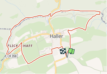
Trail Walking of 6.2 km to be discovered at Unknown, Canton Echternach, Waldbillig. This trail is proposed by mumu.larandonneuse.

Description

Sentier varié offrant forêts, rochers, eau et champs, adapté aux familles.

Cette belle randonnée de presque 6 km prend son départ dans le pittoresque village de Haller. Sur des sentiers faciles, cette randonnée offre un mélange de rochers et de prés. Tout d'abord, le chemin serpente à travers la vallée sauvage et romantique de Hallerbach et passe devant l'ancien moulin. Vous longez ensuite des formations rocheuses impressionnantes  telles que "Ellerlee".

Le chemin du retour passe à côté de champs et prairies, puis par le centre du village pour revenir au point de départ.

Le circuit convient aux familles, mais n'est pas adapté aux poussettes.

ℹ️ https://www.mullerthal-trail.lu/fr/fiche/walking/sentier-local-w4
.

Elevation profile

Photos

Positioning

Country:
Luxembourg
Region :
Unknown
Department/Province :
Canton Echternach
Municipality :
Waldbillig
Location:
Unknown
Start:(UTM)
304758 ; 5521668 (32U) N.

Comments

Please log in to post a review or rate the element


Magnifique balade, facile pour les familles.


Trails nearby

Trail Walking Consdorf - 2023-06-19_09h33m43_Sentier_local_-_C6 - Photo
Walking
GUIDE
mumu.larandonneuse

Walking

Medium
(1)
Consdorf, Unknown, Canton Echternach, Luxembourg
5.8 km | 7.3 km-effort
1h 39min
Yes
Trail Walking Consdorf - 2023-06-13_20h43m48_Sentier_local_-_C2 - Photo
Walking
GUIDE
mumu.larandonneuse

Walking

Easy
(1)
Consdorf, Unknown, Canton Echternach, Luxembourg
4.2 km | 5.5 km-effort
1h 15min
Yes
Trail Walking Consdorf - 2023-06-13_20h03m09_Circuit_auto-pdestre_Consdorf_-_Mullerthal - Photo
Walking
GUIDE
mumu.larandonneuse

Walking

Medium
(2)
Consdorf, Unknown, Canton Echternach, Luxembourg
9 km | 12.3 km-effort
2h 48min
Yes
Trail Walking Berdorf - Berdorf - B2 - Müllerthal - Photo
Walking
GUIDE
mumu.larandonneuse

Walking

Medium
(2)
Berdorf, Unknown, Canton Echternach, Luxembourg
6.7 km | 8.5 km-effort
1h 35min
Yes
Trail Walking Beaufort - 2021-07-05_20h10m00_gpx-file (1) - Photo
Walking
GUIDE
mumu.larandonneuse

Walking

Medium
(1)
Beaufort, Unknown, Canton Echternach, Luxembourg
10.6 km | 13.6 km-effort
3h 5min
Yes
Trail Walking Beaufort - 2021-07-05_19h47m20_gpx-file - Photo
Walking
GUIDE
mumu.larandonneuse

Walking

Medium
(2)
Beaufort, Unknown, Canton Echternach, Luxembourg
12.9 km | 16.8 km-effort
3h 48min
Yes
Trail Walking Consdorf - 2023-06-21_17h04m10_Sentier_local_-_C1 (1) - Photo
Walking
GUIDE
mumu.larandonneuse

Walking

Easy
(1)
Consdorf, Unknown, Canton Echternach, Luxembourg
1.9 km | 2.5 km-effort
34min
Yes
Trail Walking Berdorf - 2023-06-03_18h17m36_Sentier_local_-_B8 - Photo
Walking
GUIDE
mumu.larandonneuse

Walking

Medium
(2)
Berdorf, Unknown, Canton Echternach, Luxembourg
11.7 km | 15 km-effort
3h 24min
Yes
Trail Walking Waldbillig - Mullerthal randonnée magnifique - Photo
Walking
Alfredy

Walking

Difficult
(4)
Waldbillig, Unknown, Canton Echternach, Luxembourg
9.3 km | 12.9 km-effort
4h 21min
Yes


Close
My subscriptions