Trail Horseback riding Jaulny - Jaulny Ancy sur Moselle  - Photo

Jaulny Ancy sur Moselle

© OpenStreetMap contributors
Length
Length
27 km
Max alt
Max alt
352 m
Uphill gradient
Uphill gradient
761 m
Km-Effort
Km-Effort  
37 km
Min alt
Min alt
183 m
Downhill gradient
Downhill gradient
729 m
Boucle
Boucle
No
Creation date :
2024-08-08 09:16:08.414
Updated on :
2024-08-14 19:34:30.996

(0 Reviews)

Horseback riding
Horseback riding
4h53
Difficulty : Difficult

Scan this QR Code to open this trail in the SityTrail application

FREE GPS app for hiking

Logo SityTrail SityTrail

IGN / Geographical institutes

Download SityTrail from the App Store Download SityTrail from Google Play

Logo SityTrail SityTrail World

The world is yours!

Download SityTrail from the App Store Download SityTrail from Google Play Download SityTrail on Huawei AppGallery

About

Trail Horseback riding of 27 km to be discovered at Grand Est, Meurthe-et-Moselle, Jaulny. This trail is proposed by claude-aei.

Description

3éme étape "Entre Côtes de Meuse et Côtes de Moselle"
Point d'eau (avec seau) et aire de pique nique à Onville.
Nombreux lavoirs dans les villages traversés
Chevaux et cavaliers au Domaine les béliers à Ancy sur Moselle

Elevation profile

Positioning

Country:
France
Region :
Grand Est
Department/Province :
Meurthe-et-Moselle
Municipality :
Jaulny
Location:
Unknown
Start:(UTM)
711166 ; 5427688 (31U) N.

Trails nearby

Trail Cycle Jaulny - La vallée du Rupt de Mad - Circuit n° 14 - Jaulny - Photo
Cycle
tracegps

Cycle

Easy
Jaulny, Grand Est, Meurthe-et-Moselle, France
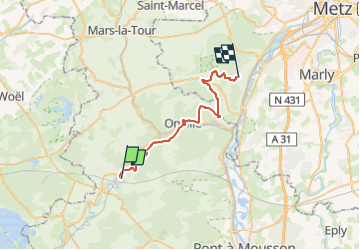
19.1 km | 22 km-effort
1h 0min
Yes
Trail Cycle Thiaucourt-Regniéville - Les paysages de l'Histoire (option Flirey) - Circuit n° 13 - Photo
Cycle
tracegps

Cycle

Difficult
Thiaucourt-Regniéville, Grand Est, Meurthe-et-Moselle, France
60 km | 68 km-effort
3h 0min
Yes
Trail Cycle Thiaucourt-Regniéville - Les paysages de l'Histoire - Circuit n° 13 - Thiaucourt Regniéville - Photo
Cycle
tracegps

Cycle

Medium
Thiaucourt-Regniéville, Grand Est, Meurthe-et-Moselle, France
49 km | 56 km-effort
2h 30min
Yes
Trail Walking Thiaucourt-Regniéville - Thiaucourt viaduc Bouillonville - Photo
Walking
kikkko

Walking

Difficult
Thiaucourt-Regniéville, Grand Est, Meurthe-et-Moselle, France
10 km | 12.3 km-effort
2h 47min
Yes
Trail Mountain bike Thiaucourt-Regniéville - Thiaucourt Jaulny Rembercourt - Photo
Mountain bike
kikkko

Mountain bike

Easy
Thiaucourt-Regniéville, Grand Est, Meurthe-et-Moselle, France
16.9 km | 21 km-effort
1h 36min
Yes
Trail Walking Euvezin - Euvezin Bouillonville Thiaucourt et retour par les hauts - Photo
Walking
kikkko

Walking

Medium
Euvezin, Grand Est, Meurthe-et-Moselle, France
10.9 km | 13.5 km-effort
3h 4min
Yes
Trail Walking Viéville-en-Haye - circuit des Rappes - Photo
Walking
kikkko

Walking

Easy
Viéville-en-Haye, Grand Est, Meurthe-et-Moselle, France
13.6 km | 16.2 km-effort
2h 33min
No
Trail Mountain bike Rembercourt-sur-Mad - rembercourt/thiaucourt/AR - Photo
Mountain bike
PascalKvtt

Mountain bike

Medium
Rembercourt-sur-Mad, Grand Est, Meurthe-et-Moselle, France
19.7 km | 25 km-effort
2h 29min
Yes
Trail Mountain bike Thiaucourt-Regniéville - sortie de thaucourd ctm - Photo
Mountain bike
nouga

Mountain bike

Difficult
Thiaucourt-Regniéville, Grand Est, Meurthe-et-Moselle, France
26 km | 31 km-effort
2h 30min
Yes


Close
My subscriptions