![](/images/other/stat-length.png)
![Trail Walking Rantigny - Rantigny_La Vallée de Vaux_8,1 km - Photo](https://media.geolcdn.com/t/1900/400/ext.pjpeg?maxdim=2&url=https%3A%2F%2Fstatic1.geolcdn.com%2Fsiteimages%2Fupload%2Ffiles%2F1553511878bg_sport_marche.png)
Rantigny_La Vallée de Vaux_8,1 km
Pousscailleux
User
![Length](/images/other/stat-length.png)
Length
8 km
![Max alt](https://static1.geolcdn.com/siteimages/upload/files/1508320355ic_sort_altitude_max_24dp.png)
Max alt
127 m
![Uphill gradient](https://static1.geolcdn.com/siteimages/upload/files/1508320355ic_sort_den_pos_24dp.png)
Uphill gradient
141 m
![Km-Effort](/images/other/stat-length.png)
Km-Effort
9.9 km
![Min alt](https://static1.geolcdn.com/siteimages/upload/files/1508320355ic_sort_altitude_min_24dp.png)
Min alt
50 m
![Downhill gradient](https://static1.geolcdn.com/siteimages/upload/files/1508320355ic_sort_den_neg_24dp.png)
Downhill gradient
144 m
![Boucle](https://static1.geolcdn.com/siteimages/upload/files/16400158638029165_repeat_loop_refresh_sync_direction_icon.png)
Boucle
Yes
Creation date :
2015-05-03 00:00:00.0
Updated on :
2015-05-03 00:00:00.0
![Walking](https://static1.geolcdn.com/sitytour/trail-icons/101.png)
2h02
Difficulty : Easy
![Scan this QR Code to open this trail in the SityTrail application](https://capi.geolives.com/qq0zvz2zws4bq2lad0pu/sitytour/trails/414559/qr.png?size=200)
FREE GPS app for hiking
About
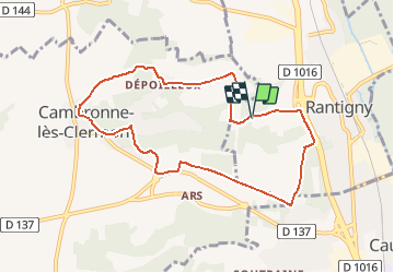
Trail Walking of 8 km to be discovered at Hauts-de-France, Oise, Rantigny. This trail is proposed by Pousscailleux.
Description
Départ du nouveau cimetière de Rantigny. Coordonnées GPS : N49°19'48.14"/E002°25'35.37". Totalement balisé en jaune, cet itinéraire reprend une partie du circuit "La montagne de Rantigny" www.oise-randonnee.com.
Positioning
Country:
France
Region :
Hauts-de-France
Department/Province :
Oise
Municipality :
Rantigny
Location:
Unknown
Start:(Dec)
Start:(UTM)
458334 ; 5464298 (31U) N.
Comments
Trails nearby
![Trail Walking Bailleval - Rando cavée des Vaches - Photo](https://media.geolcdn.com/t/375/260/f37983ff-a1d8-4a86-849e-b7078bba4408.jpg&format=jpg&maxdim=2)
![Walking Walking](https://static1.geolcdn.com/sitytour/trail-icons/101.png)
Rando cavée des Vaches
Walking
Easy
Bailleval,
Hauts-de-France,
Oise,
France
![](/images/other/stat-length.png)
9.5 km | 11.6 km-effort
2h 49min
![](https://static1.geolcdn.com/siteimages/upload/files/16400158638029165_repeat_loop_refresh_sync_direction_icon.png)
Yes
![Trail Walking Verderonne - Randonnée de Rosoy à Verderonne - Photo](https://media.geolcdn.com/t/375/260/ext.jpg?maxdim=2&url=https%3A%2F%2Fservices.sitytrail.com%2FGeolivesWS%2FDownloadMedia.ashx%3FTrailID%3D106475%26Media%3D10997_1.jpg)
![Walking Walking](https://static1.geolcdn.com/sitytour/trail-icons/101.png)
Randonnée de Rosoy à Verderonne
Walking
Medium
Verderonne,
Hauts-de-France,
Oise,
France
![](/images/other/stat-length.png)
8.3 km | 9.9 km-effort
1h 30min
![](https://static1.geolcdn.com/siteimages/upload/files/16400158638029165_repeat_loop_refresh_sync_direction_icon.png)
Yes
![Trail Walking Breuil-le-Sec - 2024 07 27 - Photo](https://media.geolcdn.com/t/375/260/ext.jpg?maxdim=2&url=https%3A%2F%2Fstatic1.geolcdn.com%2Fsiteimages%2Fupload%2Ffiles%2F1553511878bg_sport_marche.png)
![Walking Walking](https://static1.geolcdn.com/sitytour/trail-icons/101.png)
2024 07 27
Walking
Easy
Breuil-le-Sec,
Hauts-de-France,
Oise,
France
![](/images/other/stat-length.png)
16.3 km | 21 km-effort
4h 0min
![](https://static1.geolcdn.com/siteimages/upload/files/16400158638029165_repeat_loop_refresh_sync_direction_icon.png)
Yes
![Trail Walking Rantigny - Vaux Cambrone - Photo](https://media.geolcdn.com/t/375/260/7c14bdf1-d89c-4420-8bc5-b019b2f1a6db.jpg&format=jpg&maxdim=2)
![Walking Walking](https://static1.geolcdn.com/sitytour/trail-icons/101.png)
![Trail Walking Laigneville - Laigneville-Barisseuse 8k2 - Photo](https://media.geolcdn.com/t/375/260/ext.jpg?maxdim=2&url=https%3A%2F%2Fstatic1.geolcdn.com%2Fsiteimages%2Fupload%2Ffiles%2F1553511878bg_sport_marche.png)
![Walking Walking](https://static1.geolcdn.com/sitytour/trail-icons/101.png)
Laigneville-Barisseuse 8k2
Walking
Medium
Laigneville,
Hauts-de-France,
Oise,
France
![](/images/other/stat-length.png)
8.2 km | 9.7 km-effort
2h 11min
![](https://static1.geolcdn.com/siteimages/upload/files/16400158638029165_repeat_loop_refresh_sync_direction_icon.png)
Yes
![Trail Electric bike Breuil-le-Sec - 2023 12 03 - Photo](https://media.geolcdn.com/t/375/260/ext.jpg?maxdim=2&url=https%3A%2F%2Fstatic1.geolcdn.com%2Fsiteimages%2Fupload%2Ffiles%2F1524743154velo.jpg)
![Electric bike Electric bike](https://static1.geolcdn.com/sitytour/trail-icons/205.png)
2023 12 03
Electric bike
Medium
Breuil-le-Sec,
Hauts-de-France,
Oise,
France
![](/images/other/stat-length.png)
38 km | 51 km-effort
3h 27min
![](https://static1.geolcdn.com/siteimages/upload/files/16400158638029165_repeat_loop_refresh_sync_direction_icon.png)
Yes
![Trail Electric bike Breuil-le-Sec - 2022 10 29 - Photo](https://media.geolcdn.com/t/375/260/ext.jpg?maxdim=2&url=https%3A%2F%2Fstatic1.geolcdn.com%2Fsiteimages%2Fupload%2Ffiles%2F1524743154velo.jpg)
![Electric bike Electric bike](https://static1.geolcdn.com/sitytour/trail-icons/205.png)
2022 10 29
Electric bike
Medium
Breuil-le-Sec,
Hauts-de-France,
Oise,
France
![](/images/other/stat-length.png)
47 km | 57 km-effort
4h 47min
![](https://static1.geolcdn.com/siteimages/upload/files/16400158638029165_repeat_loop_refresh_sync_direction_icon.png)
Yes
![Trail Electric bike Breuil-le-Sec - 2022 10 08 - Photo](https://media.geolcdn.com/t/375/260/ext.jpg?maxdim=2&url=https%3A%2F%2Fstatic1.geolcdn.com%2Fsiteimages%2Fupload%2Ffiles%2F1524743154velo.jpg)
![Electric bike Electric bike](https://static1.geolcdn.com/sitytour/trail-icons/205.png)
2022 10 08
Electric bike
Easy
Breuil-le-Sec,
Hauts-de-France,
Oise,
France
![](/images/other/stat-length.png)
29 km | 36 km-effort
3h 21min
![](https://static1.geolcdn.com/siteimages/upload/files/16400158638029165_repeat_loop_refresh_sync_direction_icon.png)
Yes
![Trail sport Monchy-Saint-Éloi - 2022-09-28_13h36m37_<CAC9XJQ5buBJim13UVmX+3WM3tvG2H9PncH-espriqxQdtYHG3Q@mailgmailcom>_chedeville-9kmsgpxchedeville-9kms - Photo](https://media.geolcdn.com/t/375/260/ext.jpg?maxdim=2&url=https%3A%2F%2Fsecurestorage.geolives.com%2Fsitytour%2Ftrail-bg%2Fdefault.jpg)
2022-09-28_13h36m37_
sport
Very easy
Monchy-Saint-Éloi,
Hauts-de-France,
Oise,
France
![](/images/other/stat-length.png)
8 km | 9.5 km-effort
Unknown
![](https://static1.geolcdn.com/siteimages/upload/files/16400158638029165_repeat_loop_refresh_sync_direction_icon.png)
Yes