Trail Canoe - kayak Saint-Christophe - Kayak  - Photo
© OpenStreetMap contributors
Length
Length
9.5 km
Max alt
Max alt
124 m
Uphill gradient
Uphill gradient
59 m
Km-Effort
Km-Effort  
10.3 km
Min alt
Min alt
106 m
Downhill gradient
Downhill gradient
67 m
Boucle
Boucle
No
Creation date :
2024-08-04 13:47:09.0
Updated on :
2024-08-04 16:53:24.045

(0 Reviews)

Canoe - kayak
Canoe - kayak
3h05
Difficulty : Unknown

Scan this QR Code to open this trail in the SityTrail application

FREE GPS app for hiking

Logo SityTrail SityTrail

IGN / Geographical institutes

Download SityTrail from the App Store Download SityTrail from Google Play

Logo SityTrail SityTrail World

The world is yours!

Download SityTrail from the App Store Download SityTrail from Google Play Download SityTrail on Huawei AppGallery

About

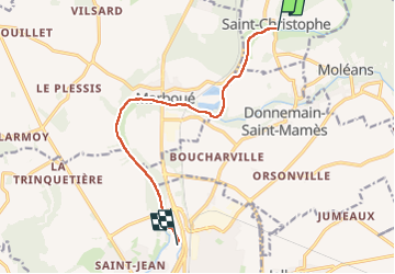
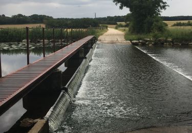
Trail Canoe - kayak of 9.5 km to be discovered at Centre-Loire Valley, Eure-et-Loir, Saint-Christophe. This trail is proposed by 000549.ac9dea4f1351435185fde59f3be1c7e2.1846.

Elevation profile

Positioning

Country:
France
Region :
Centre-Loire Valley
Department/Province :
Eure-et-Loir
Municipality :
Saint-Christophe
Location:
Unknown
Start:(UTM)
378447 ; 5331612 (31U) N.

Trails nearby

Trail Walking Saint-Maur-sur-le-Loir - Saint Maur sur le Loir - Photo
Walking
ezola

Walking

Difficult
Saint-Maur-sur-le-Loir, Centre-Loire Valley, Eure-et-Loir, France
31 km | 35 km-effort
7h 46min
Yes
Trail Canoe - kayak Châteaudun - Kayak chateaudun - Photo
Canoe - kayak
000549.ac9dea4f1351435185fde59f3be1c7e2.1846

Canoe - kayak

Châteaudun, Centre-Loire Valley, Eure-et-Loir, France
6.6 km | 7.3 km-effort
1h 59min
Yes
Trail Walking Saint-Maur-sur-le-Loir - 20240509 st maur sur loor - Photo
Walking
Jeanclaudebic

Walking

Very difficult
Saint-Maur-sur-le-Loir, Centre-Loire Valley, Eure-et-Loir, France
19.1 km | 22 km-effort
5h 19min
Yes
Trail sport Saint-Maur-sur-le-Loir - Reconnaissance à Saint-Maur, sur le Loir pour la Marche de famille - Photo
sport
ezola

sport

Very easy
(1)
Saint-Maur-sur-le-Loir, Centre-Loire Valley, Eure-et-Loir, France
19.9 km | 22 km-effort
Unknown
Yes
Trail Walking Moléans - moleans - Photo
Walking
galou29

Walking

Difficult
Moléans, Centre-Loire Valley, Eure-et-Loir, France
14.9 km | 16.6 km-effort
3h 34min
Yes
Trail Walking Bonneval - vouvray-chateaudun chateau  15,500kms - Photo
Walking
EMs86

Walking

Difficult
Bonneval, Centre-Loire Valley, Eure-et-Loir, France
15.4 km | 17.2 km-effort
3h 54min
No
Trail Walking Marboué - Rando Marboué avec Jean Pierre Castanier - Photo
Walking
ezola

Walking

Difficult
Marboué, Centre-Loire Valley, Eure-et-Loir, France
15.1 km | 17.5 km-effort
3h 11min
No
Trail Walking Saint-Maur-sur-le-Loir - 20190620saint maure  - Photo
Walking
Jeanclaudebic

Walking

Very easy
(1)
Saint-Maur-sur-le-Loir, Centre-Loire Valley, Eure-et-Loir, France
12.5 km | 14.1 km-effort
2h 47min
Yes
Trail Nordic walking Jallans - 14/05/19 - Photo
Nordic walking
sacha28

Nordic walking

Very easy
Jallans, Centre-Loire Valley, Eure-et-Loir, France
7.5 km | 8 km-effort
1h 11min
Yes


Close
My subscriptions