Trail Walking La Clusaz - SityTrail - 3349506 - le-cret-du-loup-la-clusaz (1) - Photo

SityTrail - 3349506 - le-cret-du-loup-la-clusaz (1)

 FPortier
FPortier

User

© OpenStreetMap contributors
Length
Length
11.2 km
Max alt
Max alt
1914 m
Uphill gradient
Uphill gradient
893 m
Km-Effort
Km-Effort  
23 km
Min alt
Min alt
1038 m
Downhill gradient
Downhill gradient
890 m
Boucle
Boucle
Yes
Creation date :
2024-08-03 21:11:26.304
Updated on :
2024-08-04 06:18:52.051

(0 Reviews)

Walking
Walking
5h14
Difficulty : Very difficult

Scan this QR Code to open this trail in the SityTrail application

FREE GPS app for hiking

Logo SityTrail SityTrail

IGN / Geographical institutes

Download SityTrail from the App Store Download SityTrail from Google Play

Logo SityTrail SityTrail World

The world is yours!

Download SityTrail from the App Store Download SityTrail from Google Play Download SityTrail on Huawei AppGallery

About

Trail Walking of 11.2 km to be discovered at Auvergne-Rhône-Alpes, Upper Savoy, La Clusaz. This trail is proposed by FPortier.

Description

au départ de la Clusaz prendre le télésiège jusqu'au Crêt du loup
ensuite descente jusqu'à la Clusaz dans la forêt
attention chemin pierreux, racine et gravier ne pas oublier ses bâtons de marche

Elevation profile

Positioning

Country:
France
Region :
Auvergne-Rhône-Alpes
Department/Province :
Upper Savoy
Municipality :
La Clusaz
Location:
Unknown
Start:(UTM)
300144 ; 5086702 (32T) N.

Trails nearby

Trail Snowshoes Manigod - croix de colonban croix de fry - Photo
Snowshoes
myjackotte

Snowshoes

Medium
(3)
Manigod, Auvergne-Rhône-Alpes, Upper Savoy, France
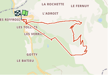
8 km | 11.6 km-effort
3h 5min
Yes
Trail Walking La Clusaz - 74.trou de la mouche la Clusaz août 2022 - Photo
Walking
GUIDE
randodyssée

Walking

Medium
La Clusaz, Auvergne-Rhône-Alpes, Upper Savoy, France
9.5 km | 24 km-effort
5h 32min
Yes
Trail Mountain bike Le Grand-Bornand - vtt-dans-la-vallee-du-bouchet - Photo
Mountain bike
GUIDE
pascalou73

Mountain bike

Very easy
Le Grand-Bornand, Auvergne-Rhône-Alpes, Upper Savoy, France
7.5 km | 10.5 km-effort
Unknown
No
Trail Mountain bike Le Grand-Bornand - VTT du grand bornand au refuge - Photo
Mountain bike
GUIDE
pascalou73

Mountain bike

Very easy
Le Grand-Bornand, Auvergne-Rhône-Alpes, Upper Savoy, France
25 km | 38 km-effort
Unknown
Yes
Trail Mountain bike Le Grand-Bornand - Le_Grand_Bornand_20210706_104522 - Photo
Mountain bike
GUIDE
pascalou73

Mountain bike

Very easy
Le Grand-Bornand, Auvergne-Rhône-Alpes, Upper Savoy, France
18.4 km | 29 km-effort
Unknown
Yes
Trail Walking La Clusaz - Les Converses, Le Planet, Beauregard, les Corbassières (boucle) - Photo
Walking
GUIDE
lhomme.ph

Walking

Difficult
La Clusaz, Auvergne-Rhône-Alpes, Upper Savoy, France
10.4 km | 17.7 km-effort
3h 11min
Yes
Trail Mountain bike Le Grand-Bornand - Le_Grand_Bornand_20200623_090207 - Photo
Mountain bike
GUIDE
pascalou73

Mountain bike

Very easy
Le Grand-Bornand, Auvergne-Rhône-Alpes, Upper Savoy, France
26 km | 38 km-effort
Unknown
No
Trail Snowshoes La Clusaz - col aravis - Photo
Snowshoes
myjackotte

Snowshoes

Easy
(2)
La Clusaz, Auvergne-Rhône-Alpes, Upper Savoy, France
5.7 km | 8.2 km-effort
2h 16min
Yes
Trail Snowshoes Thônes - Mlande Platenet Frassot  Mlande - Photo
Snowshoes
thierryd

Snowshoes

Very easy
(1)
Thônes, Auvergne-Rhône-Alpes, Upper Savoy, France
7.3 km | 13.7 km-effort
3h 24min
Yes


Close
My subscriptions