![](/images/other/stat-length.png)
![Trail Walking Orbey - Le Lac Noir - Photo](https://media.geolcdn.com/t/1900/400/079839a5-c16d-437d-a211-fe465fa5664d.jpg&format=pjpeg&maxdim=2)
Le Lac Noir
mumu.larandonneuse
User GUIDE
![Length](/images/other/stat-length.png)
Length
2 km
![Max alt](https://static1.geolcdn.com/siteimages/upload/files/1508320355ic_sort_altitude_max_24dp.png)
Max alt
1046 m
![Uphill gradient](https://static1.geolcdn.com/siteimages/upload/files/1508320355ic_sort_den_pos_24dp.png)
Uphill gradient
81 m
![Km-Effort](/images/other/stat-length.png)
Km-Effort
3.1 km
![Min alt](https://static1.geolcdn.com/siteimages/upload/files/1508320355ic_sort_altitude_min_24dp.png)
Min alt
952 m
![Downhill gradient](https://static1.geolcdn.com/siteimages/upload/files/1508320355ic_sort_den_neg_24dp.png)
Downhill gradient
84 m
![Boucle](https://static1.geolcdn.com/siteimages/upload/files/16400158638029165_repeat_loop_refresh_sync_direction_icon.png)
Boucle
Yes
Creation date :
2024-08-03 13:43:30.414
Updated on :
2024-08-04 11:56:34.266
![Walking](https://static1.geolcdn.com/sitytour/trail-icons/101.png)
41m
Difficulty : Easy
![Scan this QR Code to open this trail in the SityTrail application](https://capi.geolives.com/qq0zvz2zws4bq2lad0pu/sitytour/trails/4143074/qr.png?size=200)
FREE GPS app for hiking
About
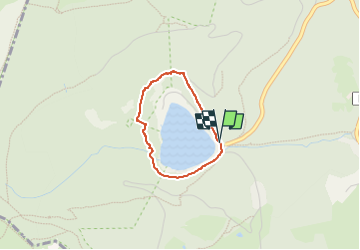
Trail Walking of 2 km to be discovered at Grand Est, Haut-Rhin, Orbey. This trail is proposed by mumu.larandonneuse.
Description
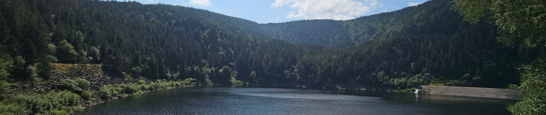
Le petit tour du Lac Noir.
Moins connu que le lac blanc situé juste à côté, le lac noir, d'une couleur foncée, est entouré de roches et de forêts de sapin.
Il est situé à une altitude de 955 m.
Positioning
Country:
France
Region :
Grand Est
Department/Province :
Haut-Rhin
Municipality :
Orbey
Location:
Unknown
Start:(Dec)
Start:(UTM)
358567 ; 5330584 (32U) N.
Comments
Trails nearby
![Trail Horseback riding Orbey - 2020-06-28 WE Orbey Petit Hohnack Glasborn - Photo](https://media.geolcdn.com/t/375/260/ef012c2d-591e-4a7a-ae45-376661550d14.jpg&format=jpg&maxdim=2)
![Horseback riding Horseback riding](https://static1.geolcdn.com/sitytour/trail-icons/301.png)
2020-06-28 WE Orbey Petit Hohnack Glasborn
Horseback riding
Difficult
(1)
Orbey,
Grand Est,
Haut-Rhin,
France
![](/images/other/stat-length.png)
22 km | 31 km-effort
4h 5min
![](https://static1.geolcdn.com/siteimages/upload/files/16400158638029165_repeat_loop_refresh_sync_direction_icon.png)
Yes
![Trail Horseback riding Orbey - 2020-06-27 WE Orbey Noir Gazon Vert Forlet - Photo](https://media.geolcdn.com/t/375/260/f691f0a3-eb26-4898-acd3-19530bfd0b6d.jpg&format=jpg&maxdim=2)
![Horseback riding Horseback riding](https://static1.geolcdn.com/sitytour/trail-icons/301.png)
2020-06-27 WE Orbey Noir Gazon Vert Forlet
Horseback riding
Medium
(1)
Orbey,
Grand Est,
Haut-Rhin,
France
![](/images/other/stat-length.png)
21 km | 30 km-effort
3h 59min
![](https://static1.geolcdn.com/siteimages/upload/files/16400158638029165_repeat_loop_refresh_sync_direction_icon.png)
Yes
![Trail Walking Stosswihr - Tour du belvedere avec le passage sur les crêtes - Photo](https://media.geolcdn.com/t/375/260/5b3c85c1-2643-45e9-9769-80e100e05dda.jpg&format=jpg&maxdim=2)
![Walking Walking](https://static1.geolcdn.com/sitytour/trail-icons/101.png)
Tour du belvedere avec le passage sur les crêtes
Walking
Very easy
(3)
Stosswihr,
Grand Est,
Haut-Rhin,
France
![](/images/other/stat-length.png)
8.5 km | 0 m-effort
2h 28min
![](https://static1.geolcdn.com/siteimages/upload/files/16400158638029165_repeat_loop_refresh_sync_direction_icon.png)
Yes
![Trail Other activity Soultzeren - Totom 4 lacs - Photo](https://media.geolcdn.com/t/375/260/ext.jpg?maxdim=2&url=https%3A%2F%2Fservices.sitytrail.com%2FGeolivesWS%2FDownloadMedia.ashx%3FTrailID%3D789048%26Media%3D20170713134427.jpg)
![Other activity Other activity](https://static1.geolcdn.com/sitytour/trail-icons/900.png)
Totom 4 lacs
Other activity
Medium
(1)
Soultzeren,
Grand Est,
Haut-Rhin,
France
![](/images/other/stat-length.png)
15.6 km | 26 km-effort
4h 37min
![](https://static1.geolcdn.com/siteimages/upload/files/16400158638029165_repeat_loop_refresh_sync_direction_icon.png)
Yes
![Trail Walking Orbey - Le Tour du Lac Blanc par le Rocher Hans et le sentier de crête - Photo](https://media.geolcdn.com/t/375/260/ext.jpg?maxdim=2&url=https%3A%2F%2Fservices.sitytrail.com%2FGeolivesWS%2FDownloadMedia.ashx%3FTrailID%3D112616%26Media%3D11189_5.jpg)
![Walking Walking](https://static1.geolcdn.com/sitytour/trail-icons/101.png)
Le Tour du Lac Blanc par le Rocher Hans et le sentier de crête
Walking
Difficult
(3)
Orbey,
Grand Est,
Haut-Rhin,
France
![](/images/other/stat-length.png)
4.4 km | 7.7 km-effort
2h 30min
![](https://static1.geolcdn.com/siteimages/upload/files/16400158638029165_repeat_loop_refresh_sync_direction_icon.png)
Yes
![Trail Walking Le Bonhomme - Tête des faux . - Photo](https://media.geolcdn.com/t/375/260/84fec98d-7f8b-4bf8-a434-52c0363ad440.jpg&format=jpg&maxdim=2)
![Walking Walking](https://static1.geolcdn.com/sitytour/trail-icons/101.png)
Tête des faux .
Walking
Medium
(1)
Le Bonhomme,
Grand Est,
Haut-Rhin,
France
![](/images/other/stat-length.png)
11.9 km | 16.6 km-effort
3h 46min
![](https://static1.geolcdn.com/siteimages/upload/files/16400158638029165_repeat_loop_refresh_sync_direction_icon.png)
Yes
![Trail Walking Soultzeren - Tanet-Gazon du faing par lac vert et retour sommet du Tanet - Photo](https://media.geolcdn.com/t/375/260/ed68be74-246f-440b-833e-a0b4a96a4c20.jpg&format=jpg&maxdim=2)
![Walking Walking](https://static1.geolcdn.com/sitytour/trail-icons/101.png)
Tanet-Gazon du faing par lac vert et retour sommet du Tanet
Walking
Medium
(1)
Soultzeren,
Grand Est,
Haut-Rhin,
France
![](/images/other/stat-length.png)
10 km | 15.6 km-effort
4h 24min
![](https://static1.geolcdn.com/siteimages/upload/files/16400158638029165_repeat_loop_refresh_sync_direction_icon.png)
Yes
![Trail Walking Lapoutroie - 2012-06-16 Marche aux Alisiers Orbey - Photo](https://media.geolcdn.com/t/375/260/ext.jpg?maxdim=2&url=https%3A%2F%2Fstatic1.geolcdn.com%2Fsiteimages%2Fupload%2Ffiles%2F1553511878bg_sport_marche.png)
![Walking Walking](https://static1.geolcdn.com/sitytour/trail-icons/101.png)
2012-06-16 Marche aux Alisiers Orbey
Walking
Easy
(2)
Lapoutroie,
Grand Est,
Haut-Rhin,
France
![](/images/other/stat-length.png)
11.1 km | 16.6 km-effort
2h 49min
![](https://static1.geolcdn.com/siteimages/upload/files/16400158638029165_repeat_loop_refresh_sync_direction_icon.png)
Yes
![Trail Mountain bike Orbey - Lac Blanc - Têtes des Faux - Photo](https://media.geolcdn.com/t/375/260/ext.jpg?maxdim=2&url=https%3A%2F%2Fservices.sitytrail.com%2FGeolivesWS%2FDownloadMedia.ashx%3FTrailID%3D101197%26Media%3D684_1.jpg)
![Mountain bike Mountain bike](https://static1.geolcdn.com/sitytour/trail-icons/202.png)
Lac Blanc - Têtes des Faux
Mountain bike
Medium
(1)
Orbey,
Grand Est,
Haut-Rhin,
France
![](/images/other/stat-length.png)
15.3 km | 21 km-effort
1h 0min
![](https://static1.geolcdn.com/siteimages/upload/files/16400158638029165_repeat_loop_refresh_sync_direction_icon.png)
Yes