Trail Walking Saint-Martin-Vésubie - boucle refuge de Cougourde/lac de Ttecolpas/ Pas des Ladres - Photo

boucle refuge de Cougourde/lac de Ttecolpas/ Pas des Ladres

© OpenStreetMap contributors
Length
Length
13.8 km
Max alt
Max alt
2439 m
Uphill gradient
Uphill gradient
883 m
Km-Effort
Km-Effort  
26 km
Min alt
Min alt
1614 m
Downhill gradient
Downhill gradient
874 m
Boucle
Boucle
Yes
Creation date :
2024-08-03 08:00:54.045
Updated on :
2024-08-03 13:51:26.113

(0 Reviews)

Walking
Walking
4h33
Difficulty : Difficult

Scan this QR Code to open this trail in the SityTrail application

FREE GPS app for hiking

Logo SityTrail SityTrail

IGN / Geographical institutes

Download SityTrail from the App Store Download SityTrail from Google Play

Logo SityTrail SityTrail World

The world is yours!

Download SityTrail from the App Store Download SityTrail from Google Play Download SityTrail on Huawei AppGallery

About

Trail Walking of 13.8 km to be discovered at Provence-Alpes-Côte d'Azur, Maritime Alps, Saint-Martin-Vésubie. This trail is proposed by PVERTICAL.

Description

depuis la Vacherie de Boreon. possibilité de raccourcir en restant au lac.

Elevation profile

Photos

Positioning

Country:
France
Region :
Provence-Alpes-Côte d'Azur
Department/Province :
Maritime Alps
Municipality :
Saint-Martin-Vésubie
Location:
Unknown
Start:(UTM)
364523 ; 4885459 (32T) N.

Trails nearby

Trail Walking Saint-Martin-Vésubie - Lac de Trécolpas - Photo
Walking
patsure

Walking

Medium
(2)
Saint-Martin-Vésubie, Provence-Alpes-Côte d'Azur, Maritime Alps, France
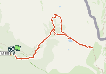
13.3 km | 20 km-effort
4h 17min
Yes
Trail On foot Saint-Martin-Vésubie - SityTrail - Lacs de Prals - Photo
On foot
GUIDE
toutankhcarton

On foot

Easy
(1)
Saint-Martin-Vésubie, Provence-Alpes-Côte d'Azur, Maritime Alps, France
6.7 km | 13.6 km-effort
3h 5min
Yes
Trail Walking Saint-Martin-Vésubie - lacs bessons - Photo
Walking
REYPatrick

Walking

Very easy
(1)
Saint-Martin-Vésubie, Provence-Alpes-Côte d'Azur, Maritime Alps, France
13.1 km | 0 m-effort
7h 36min
Yes
Trail Walking Saint-Martin-Vésubie - Lac Ne`gre bis - Photo
Walking
kenhava

Walking

Medium
(1)
Saint-Martin-Vésubie, Provence-Alpes-Côte d'Azur, Maritime Alps, France
13.1 km | 23 km-effort
3h 42min
Yes
Trail On foot Saint-Martin-Vésubie - Col de Cerise - Photo
On foot
GUIDE+

On foot

Medium
Saint-Martin-Vésubie, Provence-Alpes-Côte d'Azur, Maritime Alps, France
9.7 km | 23 km-effort
5h 18min
Yes
Trail On foot Saint-Martin-Vésubie - Circuit de Fenestre - Photo
On foot
GUIDE+

On foot

Easy
Saint-Martin-Vésubie, Provence-Alpes-Côte d'Azur, Maritime Alps, France
8.1 km | 16.4 km-effort
3h 44min
Yes
Trail On foot Saint-Martin-Vésubie - Circuit de Trécolpas - Photo
On foot
GUIDE+

On foot

Easy
Saint-Martin-Vésubie, Provence-Alpes-Côte d'Azur, Maritime Alps, France
8.9 km | 15.8 km-effort
3h 35min
Yes
Trail On foot Entracque - (SI E09) Rifugio Rifugio Soria-Ellena - Rifugio Genova-Figari - Photo
On foot
GUIDE+

On foot

Easy
Entracque, Piemont, Cuneo, Italy
7.1 km | 15.6 km-effort
3h 32min
No
Trail Touring skiing Saint-Martin-Vésubie - Col de cerise et lac du Mercantour - Photo
Touring skiing
GUIDE
nadd73

Touring skiing

Medium
Saint-Martin-Vésubie, Provence-Alpes-Côte d'Azur, Maritime Alps, France
11.9 km | 29 km-effort
7h 39min
Yes


Close
My subscriptions