![](/images/other/stat-length.png)
![Trail Walking La Chapelle-en-Vercors - serre plumé depuis carri par la bournette col de la baume grange de vauneyre col de la mure puis les cretes jusqu a pré bellet refuge de crobache lievre blanc scialet royer - Photo](https://media.geolcdn.com/t/1900/400/82d39288-8889-4dde-9abf-27f32f728f38.jpg&format=pjpeg&maxdim=2)
serre plumé depuis carri par la bournette col de la baume grange de vauneyre col de la mure puis les cretes jusqu a pré bellet refuge de crobache lievre blanc scialet royer
bsateddy26
User
![Length](/images/other/stat-length.png)
Length
15.5 km
![Max alt](https://static1.geolcdn.com/siteimages/upload/files/1508320355ic_sort_altitude_max_24dp.png)
Max alt
1562 m
![Uphill gradient](https://static1.geolcdn.com/siteimages/upload/files/1508320355ic_sort_den_pos_24dp.png)
Uphill gradient
694 m
![Km-Effort](/images/other/stat-length.png)
Km-Effort
25 km
![Min alt](https://static1.geolcdn.com/siteimages/upload/files/1508320355ic_sort_altitude_min_24dp.png)
Min alt
1204 m
![Downhill gradient](https://static1.geolcdn.com/siteimages/upload/files/1508320355ic_sort_den_neg_24dp.png)
Downhill gradient
687 m
![Boucle](https://static1.geolcdn.com/siteimages/upload/files/16400158638029165_repeat_loop_refresh_sync_direction_icon.png)
Boucle
Yes
Creation date :
2024-08-02 14:43:26.958
Updated on :
2024-08-02 15:54:46.745
![Walking](https://static1.geolcdn.com/sitytour/trail-icons/101.png)
5h36
Difficulty : Very difficult
![Scan this QR Code to open this trail in the SityTrail application](https://capi.geolives.com/qq0zvz2zws4bq2lad0pu/sitytour/trails/4142207/qr.png?size=200)
FREE GPS app for hiking
About
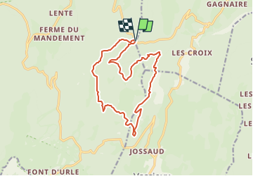
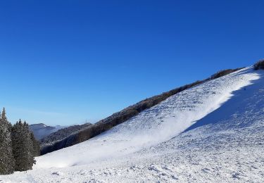
Trail Walking of 15.5 km to be discovered at Auvergne-Rhône-Alpes, Drôme, La Chapelle-en-Vercors. This trail is proposed by bsateddy26.
Description
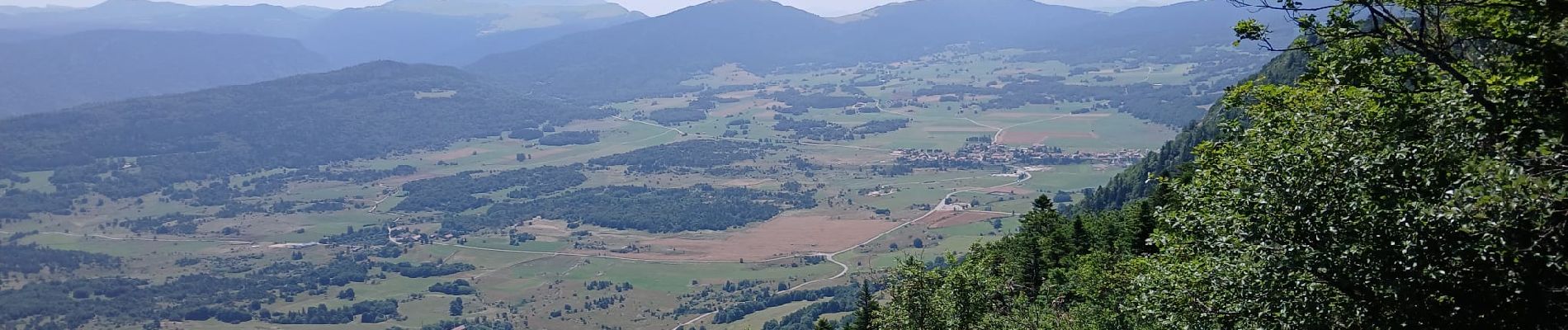
magnifique balade bien ombragée pour le plein été avec vu sur les pelouses et point de vu dégagé magnifque depuis le serre Plumé
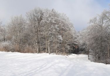
Positioning
Country:
France
Region :
Auvergne-Rhône-Alpes
Department/Province :
Drôme
Municipality :
La Chapelle-en-Vercors
Location:
Unknown
Start:(Dec)
Start:(UTM)
686386 ; 4979453 (31T) N.
Comments
Trails nearby
![Trail Snowshoes Bouvante - Les gagères en raquettes - Photo](https://media.geolcdn.com/t/375/260/2981cf80-2281-48d0-9011-dd17ca071224.jpg&format=jpg&maxdim=2)
![Snowshoes Snowshoes](https://static1.geolcdn.com/sitytour/trail-icons/504.png)
Les gagères en raquettes
Snowshoes
Medium
(1)
Bouvante,
Auvergne-Rhône-Alpes,
Drôme,
France
![](/images/other/stat-length.png)
9.2 km | 14.2 km-effort
3h 40min
![](https://static1.geolcdn.com/siteimages/upload/files/16400158638029165_repeat_loop_refresh_sync_direction_icon.png)
Yes
![Trail Snowshoes La Chapelle-en-Vercors - 26 raq claveyron - Photo](https://media.geolcdn.com/t/375/260/d59c2ca4-fd91-4928-b5ba-f5a74d483fc8.jpg&format=jpg&maxdim=2)
![Snowshoes Snowshoes](https://static1.geolcdn.com/sitytour/trail-icons/504.png)
26 raq claveyron
Snowshoes
Medium
La Chapelle-en-Vercors,
Auvergne-Rhône-Alpes,
Drôme,
France
![](/images/other/stat-length.png)
15.2 km | 23 km-effort
7h 51min
![](https://static1.geolcdn.com/siteimages/upload/files/16400158638029165_repeat_loop_refresh_sync_direction_icon.png)
Yes
![Trail Walking La Chapelle-en-Vercors - Serre Plumé - Photo](https://media.geolcdn.com/t/375/260/86da3767-95d8-4e79-b2dd-2495b2dc9585.jpg&format=jpg&maxdim=2)
![Walking Walking](https://static1.geolcdn.com/sitytour/trail-icons/101.png)
Serre Plumé
Walking
Medium
La Chapelle-en-Vercors,
Auvergne-Rhône-Alpes,
Drôme,
France
![](/images/other/stat-length.png)
7.2 km | 11.5 km-effort
2h 42min
![](https://static1.geolcdn.com/siteimages/upload/files/16400158638029165_repeat_loop_refresh_sync_direction_icon.png)
Yes
![Trail Walking Bouvante - Boucle du Plateau de Font d'Urle - Photo](https://media.geolcdn.com/t/375/260/50aac9f1-41c9-480c-904d-17b530d5dbff.jpg&format=jpg&maxdim=2)
![Walking Walking](https://static1.geolcdn.com/sitytour/trail-icons/101.png)
Boucle du Plateau de Font d'Urle
Walking
Difficult
Bouvante,
Auvergne-Rhône-Alpes,
Drôme,
France
![](/images/other/stat-length.png)
11.2 km | 16.8 km-effort
3h 49min
![](https://static1.geolcdn.com/siteimages/upload/files/16400158638029165_repeat_loop_refresh_sync_direction_icon.png)
Yes
![Trail Walking Bouvante - Font d’Urle les Trois cloches Glacières les Gagères - Photo](https://media.geolcdn.com/t/375/260/d811593c-e678-4b00-a285-b7dce29eecce.jpg&format=jpg&maxdim=2)
![Walking Walking](https://static1.geolcdn.com/sitytour/trail-icons/101.png)
Font d’Urle les Trois cloches Glacières les Gagères
Walking
Difficult
Bouvante,
Auvergne-Rhône-Alpes,
Drôme,
France
![](/images/other/stat-length.png)
11.9 km | 17.9 km-effort
4h 4min
![](https://static1.geolcdn.com/siteimages/upload/files/16400158638029165_repeat_loop_refresh_sync_direction_icon.png)
Yes
![Trail Walking Bouvante - Col de la Machine - Photo](https://media.geolcdn.com/t/375/260/0d18de73-0fe0-48b2-b5db-96ecf4348995.jpg&format=jpg&maxdim=2)
![Walking Walking](https://static1.geolcdn.com/sitytour/trail-icons/101.png)
Col de la Machine
Walking
Difficult
Bouvante,
Auvergne-Rhône-Alpes,
Drôme,
France
![](/images/other/stat-length.png)
11.6 km | 16.3 km-effort
3h 42min
![](https://static1.geolcdn.com/siteimages/upload/files/16400158638029165_repeat_loop_refresh_sync_direction_icon.png)
Yes
![Trail Walking Bouvante - Crête des Gagères - Photo](https://media.geolcdn.com/t/375/260/238839e4-2c7b-463c-a8a4-13f730b00e0a.jpg&format=jpg&maxdim=2)
![Walking Walking](https://static1.geolcdn.com/sitytour/trail-icons/101.png)
Crête des Gagères
Walking
Medium
Bouvante,
Auvergne-Rhône-Alpes,
Drôme,
France
![](/images/other/stat-length.png)
8.3 km | 11.6 km-effort
2h 10min
![](https://static1.geolcdn.com/siteimages/upload/files/16400158638029165_repeat_loop_refresh_sync_direction_icon.png)
Yes
![Trail Nordic walking Bouvante - 202201fontdurle2 - Photo](https://media.geolcdn.com/t/375/260/148c551f-c1f7-4a77-89d2-b6cfec149cab.jpg&format=jpg&maxdim=2)
![Nordic walking Nordic walking](https://static1.geolcdn.com/sitytour/trail-icons/102.png)
202201fontdurle2
Nordic walking
Very easy
Bouvante,
Auvergne-Rhône-Alpes,
Drôme,
France
![](/images/other/stat-length.png)
4.3 km | 6 km-effort
1h 58min
![](https://static1.geolcdn.com/siteimages/upload/files/16400158638029165_repeat_loop_refresh_sync_direction_icon.png)
Yes
![Trail Walking Bouvante - 2lente tubanet zel raquette - Photo](https://media.geolcdn.com/t/375/260/b869f45f-97e2-4558-9595-bf93aaf9d9e8.jpg&format=jpg&maxdim=2)
![Walking Walking](https://static1.geolcdn.com/sitytour/trail-icons/101.png)
2lente tubanet zel raquette
Walking
Medium
Bouvante,
Auvergne-Rhône-Alpes,
Drôme,
France
![](/images/other/stat-length.png)
16.9 km | 21 km-effort
6h 42min
![](https://static1.geolcdn.com/siteimages/upload/files/16400158638029165_repeat_loop_refresh_sync_direction_icon.png)
Yes