Trail Horseback riding Avelin - Avelin - Bernissart - ATE Randoligue 2024 - Photo

Avelin - Bernissart - ATE Randoligue 2024

© OpenStreetMap contributors
Length
Length
84 km
Max alt
Max alt
63 m
Uphill gradient
Uphill gradient
516 m
Km-Effort
Km-Effort  
91 km
Min alt
Min alt
13 m
Downhill gradient
Downhill gradient
540 m
Boucle
Boucle
No
Creation date :
2024-07-31 12:15:15.073
Updated on :
2024-08-05 14:41:01.891

(0 Reviews)

Horseback riding
Horseback riding
11h54
Difficulty : Very difficult

Scan this QR Code to open this trail in the SityTrail application

FREE GPS app for hiking

Logo SityTrail SityTrail

IGN / Geographical institutes

Download SityTrail from the App Store Download SityTrail from Google Play

Logo SityTrail SityTrail World

The world is yours!

Download SityTrail from the App Store Download SityTrail from Google Play Download SityTrail on Huawei AppGallery

About

Trail Horseback riding of 84 km to be discovered at Hauts-de-France, Nord, Avelin. This trail is proposed by Eugénie Duhez (Uto&Co).

Elevation profile

Photos

Points of interest

Point of interest Vred - Les écuries de la Traitoire   - Photo
Eugénie Duhez (Uto&Co)
Point of interest Saint-Amand-les-Eaux - Ecurie de l'orée du bois  - Photo
Eugénie Duhez (Uto&Co)
SAINT-AMAND-LES-EAUX 
Point of interest Raismes - Gite la Clé des bois  - Photo
Eugénie Duhez (Uto&Co)
Point of interest Faumont - Petit parc avec une clairiére ombragée - Point repas du 1er midi - Photo
Eugénie Duhez (Uto&Co)
Point of interest Warlaing - Petite chapelle ombragée - pause déjeunée du 2nd jour - Photo
Eugénie Duhez (Uto&Co)
Point of interest Vieux-Condé - Entrée de la forêt de de Bernissart - Midi J3 - Photo
Eugénie Duhez (Uto&Co)

Positioning

Country:
France
Region :
Hauts-de-France
Department/Province :
Nord
Municipality :
Avelin
Location:
Unknown
Start:(UTM)
505686 ; 5597868 (31U) N.

Trails nearby

Trail Walking Ennevelin - Circuit d'Aigremont - Photo
Walking
tracegps

Walking

Medium
(1)
Ennevelin, Hauts-de-France, Nord, France
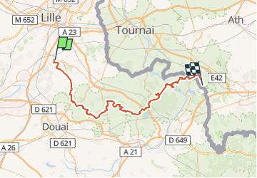
11.1 km | 11.8 km-effort
2h 45min
Yes
Trail Walking Fretin - Sur les traces de Philippe II Auguste - Photo
Walking

Walking

Easy
(1)
Fretin, Hauts-de-France, Nord, France
26 km | 28 km-effort
5h 12min
Yes
Trail Walking Fretin - fretin et ses marais - Photo
Walking
dehemjacques

Walking

Easy
(2)
Fretin, Hauts-de-France, Nord, France
12 km | 12.7 km-effort
2h 31min
Yes
Trail Walking Avelin - circuit des chicons - Photo
Walking
dehemjacques

Walking

Easy
Avelin, Hauts-de-France, Nord, France
11.7 km | 12.5 km-effort
2h 21min
Yes
Trail On foot Fretin - Fretin - Seclin par le GR121B (option Phalempin) - Photo
On foot

On foot

Medium
Fretin, Hauts-de-France, Nord, France
23 km | 25 km-effort
5h 41min
No
Trail Walking Fretin - Trajet simple FRETIN -121b - MARCQ - Photo
Walking

Walking

Medium
Fretin, Hauts-de-France, Nord, France
31 km | 34 km-effort
6h 0min
No
Trail Walking Seclin - seclin bis 12,5 km - Photo
Walking
GUIDE
rvapeldo

Walking

Very easy
Seclin, Hauts-de-France, Nord, France
12.7 km | 13.5 km-effort
3h 47min
Yes
Trail Walking Ennevelin - GR121B Phalempin à Ennevelin - Photo
Walking
dehemjacques

Walking

Easy
(2)
Ennevelin, Hauts-de-France, Nord, France
14.4 km | 15.6 km-effort
3h 28min
No
Trail Mountain bike Phalempin - export - Photo
Mountain bike
jcn59133

Mountain bike

Medium
(1)
Phalempin, Hauts-de-France, Nord, France
55 km | 61 km-effort
Unknown
Yes


Close
My subscriptions