Trail Road bike Peyrus - Peyrus - Cols Bataille et Machine - St Jean en Royans - Photo

Peyrus - Cols Bataille et Machine - St Jean en Royans

 thonyc
thonyc

User GUIDE

© OpenStreetMap contributors
Length
Length
99 km
Max alt
Max alt
1344 m
Uphill gradient
Uphill gradient
2753 m
Km-Effort
Km-Effort  
136 km
Min alt
Min alt
245 m
Downhill gradient
Downhill gradient
2742 m
Boucle
Boucle
No
Creation date :
2024-07-30 08:47:42.026
Updated on :
2024-08-25 08:33:20.68

(0 Reviews)

Road bike
Road bike
8h14
Difficulty : Very difficult

Scan this QR Code to open this trail in the SityTrail application

FREE GPS app for hiking

Logo SityTrail SityTrail

IGN / Geographical institutes

Download SityTrail from the App Store Download SityTrail from Google Play

Logo SityTrail SityTrail World

The world is yours!

Download SityTrail from the App Store Download SityTrail from Google Play Download SityTrail on Huawei AppGallery

About

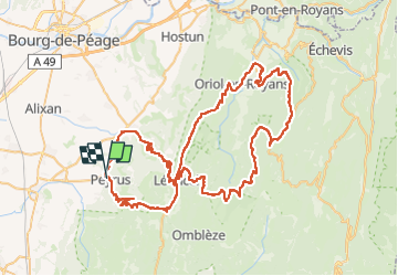
Trail Road bike of 99 km to be discovered at Auvergne-Rhône-Alpes, Drôme, Peyrus. This trail is proposed by thonyc.

Description

Les Splendides Routes du Vercors:
Cols de la bataille et de la Machine, Combe Laval
Cols des Limouches et de Tourniol
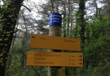
Elevation profile

Positioning

Country:
France
Region :
Auvergne-Rhône-Alpes
Department/Province :
Drôme
Municipality :
Peyrus
Location:
Unknown
Start:(Dec)
Start:(UTM)
666117 ; 4975547 (31T) N.

Trails nearby

Trail Walking Châteaudouble - Le pont des sarazins par la fontaine des corbeaux - Photo
Walking
ikusen26@gmail.com

Walking

Medium
(1)
Châteaudouble, Auvergne-Rhône-Alpes, Drôme, France
6.4 km | 11.2 km-effort
2h 57min
No
Trail Walking Saint-Vincent-la-Commanderie - Pierre Chauve 1308m, les Roches de Treillaras, depuis les Condamines - Photo
Walking
tracegps

Walking

Medium
(2)
Saint-Vincent-la-Commanderie, Auvergne-Rhône-Alpes, Drôme, France
12.7 km | 25 km-effort
6h 30min
Yes
Trail Walking Saint-Vincent-la-Commanderie - 26 st Vincent commanderie zel - Photo
Walking
GUIDE
randodyssée

Walking

Easy
Saint-Vincent-la-Commanderie, Auvergne-Rhône-Alpes, Drôme, France
14.2 km | 22 km-effort
6h 5min
Yes
Trail Walking Léoncel - les roches de treillaras - Photo
Walking
olivier26

Walking

Easy
(3)
Léoncel, Auvergne-Rhône-Alpes, Drôme, France
11 km | 16 km-effort
2h 14min
No
Trail Walking Léoncel - Rando Pas du touet -rocher de la drayette - Photo
Walking
jeebeek

Walking

Easy
(3)
Léoncel, Auvergne-Rhône-Alpes, Drôme, France
6.3 km | 8.8 km-effort
2h 11min
Yes
Trail Walking Barbières - Traversée Barbières Beauregard-Baret - Photo
Walking
GuyVachet

Walking

Very difficult
Barbières, Auvergne-Rhône-Alpes, Drôme, France
17 km | 28 km-effort
7h 9min
No
Trail Walking Peyrus - pont des sarrasins, faucon, piaroux  - Photo
Walking
bymarc26

Walking

Very difficult
Peyrus, Auvergne-Rhône-Alpes, Drôme, France
8.3 km | 14.3 km-effort
3h 2min
Yes
Trail Road bike Barcelonne - 03-05-22-14693810 - Photo
Road bike
Lucquiaud

Road bike

Very difficult
(1)
Barcelonne, Auvergne-Rhône-Alpes, Drôme, France
67 km | 88 km-effort
5h 20min
No
Trail Walking Combovin - COMBOVIN 2023 - Photo
Walking
floup6138

Walking

Medium
Combovin, Auvergne-Rhône-Alpes, Drôme, France
15.4 km | 23 km-effort
5h 20min
No


Close
My subscriptions