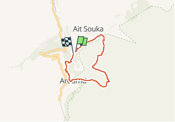
Trail Walking Asni - Imlil - Photo
 JMHRX2
JMHRX2

User

© OpenStreetMap contributors
Length
Length
6.8 km
Max alt
Max alt
2162 m
Uphill gradient
Uphill gradient
383 m
Km-Effort
Km-Effort  
12 km
Min alt
Min alt
1769 m
Downhill gradient
Downhill gradient
403 m
Boucle
Boucle
Yes
Creation date :
2024-07-15 08:04:10.776
Updated on :
2024-07-27 16:33:36.114

(0 Reviews)

Walking
Walking
3h18
Difficulty : Medium

Scan this QR Code to open this trail in the SityTrail application

FREE GPS app for hiking

Logo SityTrail SityTrail

IGN / Geographical institutes

Download SityTrail from the App Store Download SityTrail from Google Play

Logo SityTrail SityTrail World

The world is yours!

Download SityTrail from the App Store Download SityTrail from Google Play Download SityTrail on Huawei AppGallery

About

Trail Walking of 6.8 km to be discovered at Marrakech-Safi, cercle d'Asni, Asni. This trail is proposed by JMHRX2.

Elevation profile

Positioning

Country:
Morocco
Region :
Marrakech-Safi
Department/Province :
cercle d'Asni
Municipality :
Asni
Location:
Unknown
Start:(UTM)
603331 ; 3445006 (29R) N.

Trails nearby

Trail Walking Asni - Imlil refuge Toubkal - Photo
Walking
J-Mi

Walking

Medium
Asni, Marrakech-Safi, cercle d'Asni, Morocco
12.3 km | 26 km-effort
4h 20min
No
Trail Walking Asni - ilmil tizi - Photo
Walking
ribellino

Walking

Difficult
Asni, Marrakech-Safi, cercle d'Asni, Morocco
6.8 km | 13.1 km-effort
4h 14min
No
Trail Walking Asni - Imlil à Refuge les Mouflons - Photo
Walking
MathieuBourgois

Walking

Medium
Asni, Marrakech-Safi, cercle d'Asni, Morocco
10.8 km | 25 km-effort
5h 51min
No
Trail Walking Asni - Toubkal-J3 - Photo
Walking
m.rambouillet

Walking

Very easy
Asni, Marrakech-Safi, cercle d'Asni, Morocco
9.9 km | 22 km-effort
5h 56min
No


Close
My subscriptions