


Kumano Nachi Taisha Kii-Katsuura
© OpenStreetMap contributors


1h57
Difficulty : Medium


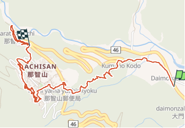
Length
4.1 km
Max alt
357 m
Uphill gradient
268 m
Km-Effort
7.1 km
Min alt
92 m
Downhill gradient
114 m
Boucle
No
Creation date :
2024-07-27 01:11:38.418
Updated on :
2024-07-27 05:28:40.098
1h57
Difficulty : Medium
FREE GPS app for hiking
 SityTrail
IGN / Geographical institutes
SityTrail World
The world is yours!
About
Trail Walking of 4.1 km to be discovered at Wakayama Prefecture, Higashimuro County. This trail is proposed by patrice_baras@yahoo.fr.
Description
temple, sanctuaire, pagode, cascade
beaucoup de marchés. montée à pied, descente en bus.
Positioning
Country:
Japan
Region :
Wakayama Prefecture
Department/Province :
Higashimuro County
Municipality :
Unknown
Location:
Unknown
Start:(Dec)
Start:(UTM)
583602 ; 3725885 (53S) N.
Comments
Trails nearby