Trail On foot Lus-la-Croix-Haute - 2024-04-17_Au fil du Buech - Photo
© OpenStreetMap contributors
Length
Length
7.5 km
Max alt
Max alt
1135 m
Uphill gradient
Uphill gradient
349 m
Km-Effort
Km-Effort  
12.2 km
Min alt
Min alt
995 m
Downhill gradient
Downhill gradient
349 m
Boucle
Boucle
Yes
Creation date :
2024-07-26 16:59:05.887
Updated on :
2024-07-26 17:09:48.703

(0 Reviews)

On foot
On foot
2h45
Difficulty : Easy

Scan this QR Code to open this trail in the SityTrail application

FREE GPS app for hiking

Logo SityTrail SityTrail

IGN / Geographical institutes

Download SityTrail from the App Store Download SityTrail from Google Play

Logo SityTrail SityTrail World

The world is yours!

Download SityTrail from the App Store Download SityTrail from Google Play Download SityTrail on Huawei AppGallery

About

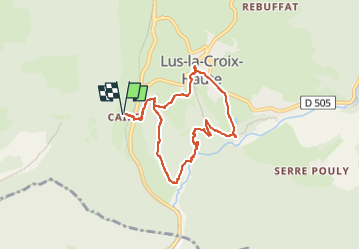
Trail On foot of 7.5 km to be discovered at Auvergne-Rhône-Alpes, Drôme, Lus-la-Croix-Haute. This trail is proposed by Christiancordin.

Description

D PK la Caire, passerelle, le Saleyras, le long du Buëch, Lus la Croix Haute, le Cheylar, la Caire.

Elevation profile

Photos

Positioning

Country:
France
Region :
Auvergne-Rhône-Alpes
Department/Province :
Drôme
Municipality :
Lus-la-Croix-Haute
Location:
Unknown
Start:(UTM)
713486 ; 4948713 (31T) N.

Trails nearby

Trail Walking Glandage - Grimone-Le Jocou 12km - Photo
Walking
GUIDE
thonyc

Walking

Difficult
Glandage, Auvergne-Rhône-Alpes, Drôme, France
12 km | 24 km-effort
6h 0min
Yes
Trail Walking Lus-la-Croix-Haute - R48 - Gorges des Amayères - Photo
Walking
GUIDE+

Walking

Easy
Lus-la-Croix-Haute, Auvergne-Rhône-Alpes, Drôme, France
10.3 km | 17.5 km-effort
3h 1min
No
Trail Walking Lus-la-Croix-Haute - Le Rognon - Photo
Walking
GAPIAN43

Walking

Medium
(1)
Lus-la-Croix-Haute, Auvergne-Rhône-Alpes, Drôme, France
12.3 km | 22 km-effort
4h 33min
Yes
Trail Walking Saint-Julien-en-Beauchêne - ST JULIEN EN BEAUCHENE- VAUNIERES - Photo
Walking
BLANCHET

Walking

Medium
(1)
Saint-Julien-en-Beauchêne, Provence-Alpes-Côte d'Azur, Hautes-Alpes, France
9.4 km | 18.4 km-effort
3h 59min
No
Trail On foot Glandage - 2024-04-16_Sucettes de Borne - Photo
On foot
Christiancordin

On foot

Difficult
Glandage, Auvergne-Rhône-Alpes, Drôme, France
18.7 km | 32 km-effort
7h 11min
Yes
Trail On foot Lus-la-Croix-Haute - 2024-04-15_L'Aupillon - Photo
On foot
Christiancordin

On foot

Medium
Lus-la-Croix-Haute, Auvergne-Rhône-Alpes, Drôme, France
8.3 km | 14.5 km-effort
3h 17min
Yes
Trail Walking Glandage - Le Jocou 2 - Photo
Walking
Marco05

Walking

Difficult
Glandage, Auvergne-Rhône-Alpes, Drôme, France
8.5 km | 18.1 km-effort
4h 0min
Yes
Trail Walking Lus-la-Croix-Haute - Pointe Feuillette - Photo
Walking
Marco05

Walking

Difficult
Lus-la-Croix-Haute, Auvergne-Rhône-Alpes, Drôme, France
10.5 km | 20 km-effort
4h 36min
Yes
Trail Walking Lus-la-Croix-Haute - Pointe feuillette  - Photo
Walking
ajd26

Walking

Medium
Lus-la-Croix-Haute, Auvergne-Rhône-Alpes, Drôme, France
11.4 km | 21 km-effort
4h 52min
Yes


Close
My subscriptions