![](/images/other/stat-length.png)
![Trail Walking Châteauneuf-du-Rhône - 26 Châteauneuf du Rhône Navon Rac - Photo](https://media.geolcdn.com/t/1900/400/ext.pjpeg?maxdim=2&url=https%3A%2F%2Fstatic1.geolcdn.com%2Fsiteimages%2Fupload%2Ffiles%2F1553511878bg_sport_marche.png)
26 Châteauneuf du Rhône Navon Rac
Maryma
User
![Length](/images/other/stat-length.png)
![Max alt](https://static1.geolcdn.com/siteimages/upload/files/1508320355ic_sort_altitude_max_24dp.png)
![Uphill gradient](https://static1.geolcdn.com/siteimages/upload/files/1508320355ic_sort_den_pos_24dp.png)
![Km-Effort](/images/other/stat-length.png)
![Min alt](https://static1.geolcdn.com/siteimages/upload/files/1508320355ic_sort_altitude_min_24dp.png)
![Downhill gradient](https://static1.geolcdn.com/siteimages/upload/files/1508320355ic_sort_den_neg_24dp.png)
![Boucle](https://static1.geolcdn.com/siteimages/upload/files/16400158638029165_repeat_loop_refresh_sync_direction_icon.png)
![Walking](https://static1.geolcdn.com/sitytour/trail-icons/101.png)
3h10
Difficulty : Medium
![Scan this QR Code to open this trail in the SityTrail application](https://capi.geolives.com/qq0zvz2zws4bq2lad0pu/sitytour/trails/4135556/qr.png?size=200)
FREE GPS app for hiking
About
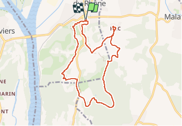
Trail Walking of 9.8 km to be discovered at Auvergne-Rhône-Alpes, Drôme, Châteauneuf-du-Rhône. This trail is proposed by Maryma.
Description
Se garer sur la place du Valladas, face à la piscine et sous le cimetière.
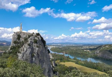
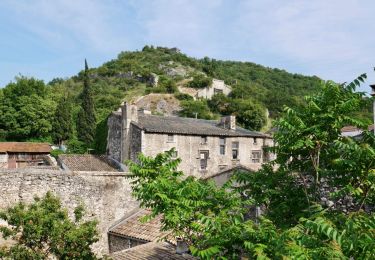
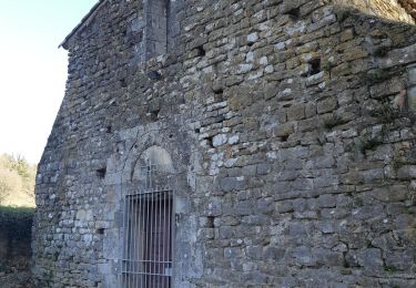
Un début de parcours par les ruelles du village médiéval de Châteauneuf du Rhône, en passant par l'église, la maison d'Arlandes avec sa façade Renaissance, le portail de Donzère. Nous commençons la rando en montant le long des remparts (11ème siècle) de la colline Montpensier par le sentier botanique. A son sommet, une vierge, en remerciement pour sa protection, domine le village. De là, un magnifique point de vue sur le village et la vallée.
Le chemin continue par la traversée de champs céréaliers comme de lavandes et de nombreux passages en sous-bois (chênes, pins, genévriers...) très agréables et souvent en monotrace.
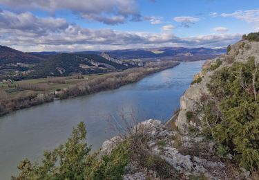
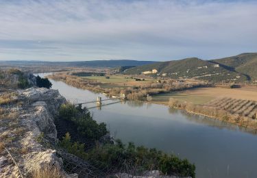
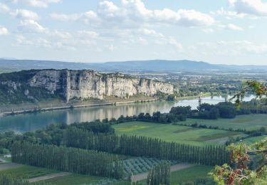
Arrivés sur la crête du Navon, à nouveau un remarquable point de vue, sur Viviers, le Rhône, la cimenterie Lafarge et la centrale de Cruas!
Après un nouveau passage en pinède, nous arrivons au hameau du Rac avec un panorama en direction de Savasse, Marsanne. Enfin la redescente par un chemin à nouveau en sous-bois, fort agréable, et monotrace.
Positioning
Comments
Trails nearby
![Trail Walking Donzère - Donzère et le défilé de Donzère 8km. - Photo](https://media.geolcdn.com/t/375/260/29640f3c-57e6-45f5-8c80-02a608564184.jpg&format=jpg&maxdim=2)
![Walking Walking](https://static1.geolcdn.com/sitytour/trail-icons/101.png)
Walking
![](/images/other/stat-length.png)
![](https://static1.geolcdn.com/siteimages/upload/files/16400158638029165_repeat_loop_refresh_sync_direction_icon.png)
![Trail Walking Viviers - 2024-08-09_18h31m30_t123518200_wanderung veviers erzengel - Photo](https://media.geolcdn.com/t/375/260/cf389799-c859-43e5-9cc2-efd706a42e44.jpg&format=jpg&maxdim=2)
![Walking Walking](https://static1.geolcdn.com/sitytour/trail-icons/101.png)
Walking
![](/images/other/stat-length.png)
![](https://static1.geolcdn.com/siteimages/upload/files/16400158638029165_repeat_loop_refresh_sync_direction_icon.png)
![Trail Walking Viviers - 2022-07-02_18h53m13_Viviers 6km.gpx.xml - Photo](https://media.geolcdn.com/t/375/260/2c7b7c3a-9657-4643-bedd-c867c3e314f0.jpg&format=jpg&maxdim=2)
![Walking Walking](https://static1.geolcdn.com/sitytour/trail-icons/101.png)
Walking
![](/images/other/stat-length.png)
![](https://static1.geolcdn.com/siteimages/upload/files/16400158638029165_repeat_loop_refresh_sync_direction_icon.png)
![Trail Walking Malataverne - Malataverne : Le Rac Le Navon 7km5. - Photo](https://media.geolcdn.com/t/375/260/0561eb90-e5f9-49cc-981c-c2636eb681f5.jpg&format=jpg&maxdim=2)
![Walking Walking](https://static1.geolcdn.com/sitytour/trail-icons/101.png)
Walking
![](/images/other/stat-length.png)
![](https://static1.geolcdn.com/siteimages/upload/files/16400158638029165_repeat_loop_refresh_sync_direction_icon.png)
![Trail Walking Donzère - Donzère -falaises-Navon-ruines 15km - Photo](https://media.geolcdn.com/t/375/260/43689114-f291-44a7-938f-e31d16f56bb8.jpg&format=jpg&maxdim=2)
![Walking Walking](https://static1.geolcdn.com/sitytour/trail-icons/101.png)
Walking
![](/images/other/stat-length.png)
![](https://static1.geolcdn.com/siteimages/upload/files/16400158638029165_repeat_loop_refresh_sync_direction_icon.png)
![Trail Walking Donzère - Donzère les falaises 6km - Photo](https://media.geolcdn.com/t/375/260/ext.jpg?maxdim=2&url=https%3A%2F%2Fstatic1.geolcdn.com%2Fsiteimages%2Fupload%2Ffiles%2F1553511878bg_sport_marche.png)
![Walking Walking](https://static1.geolcdn.com/sitytour/trail-icons/101.png)
Walking
![](/images/other/stat-length.png)
![](https://static1.geolcdn.com/siteimages/upload/files/16400158638029165_repeat_loop_refresh_sync_direction_icon.png)
![Trail Walking Viviers - 07 viviers st montan - Photo](https://media.geolcdn.com/t/375/260/3692a514-f42a-4bcb-a3a0-8b198053c1aa.jpg&format=jpg&maxdim=2)
![Walking Walking](https://static1.geolcdn.com/sitytour/trail-icons/101.png)
Walking
![](/images/other/stat-length.png)
![](https://static1.geolcdn.com/siteimages/upload/files/16400158638029165_repeat_loop_refresh_sync_direction_icon.png)
![Trail Walking Viviers - virade de l espoir viviers - Photo](https://media.geolcdn.com/t/375/260/ext.jpg?maxdim=2&url=https%3A%2F%2Fstatic1.geolcdn.com%2Fsiteimages%2Fupload%2Ffiles%2F1553511878bg_sport_marche.png)
![Walking Walking](https://static1.geolcdn.com/sitytour/trail-icons/101.png)
Walking
![](/images/other/stat-length.png)
![](https://static1.geolcdn.com/siteimages/upload/files/16400158638029165_repeat_loop_refresh_sync_direction_icon.png)
![Trail Walking Châteauneuf-du-Rhône - 2024-06-16_06h15m19_t219378880_chateauneuf du rhone - - Photo](https://media.geolcdn.com/t/375/260/a28cc877-61f7-4c8a-9cdf-70cf6be1b461.jpg&format=jpg&maxdim=2)
![Walking Walking](https://static1.geolcdn.com/sitytour/trail-icons/101.png)
Walking
![](/images/other/stat-length.png)
![](https://static1.geolcdn.com/siteimages/upload/files/16400158638029165_repeat_loop_refresh_sync_direction_icon.png)