Trail On foot Lus-la-Croix-Haute - 2024-04-15_L'Aupillon - Photo
© OpenStreetMap contributors
Length
Length
8.3 km
Max alt
Max alt
1717 m
Uphill gradient
Uphill gradient
466 m
Km-Effort
Km-Effort  
14.5 km
Min alt
Min alt
1319 m
Downhill gradient
Downhill gradient
467 m
Boucle
Boucle
Yes
Creation date :
2024-07-26 16:03:44.878
Updated on :
2024-07-26 16:20:42.951

(0 Reviews)

On foot
On foot
3h17
Difficulty : Medium

Scan this QR Code to open this trail in the SityTrail application

FREE GPS app for hiking

Logo SityTrail SityTrail

IGN / Geographical institutes

Download SityTrail from the App Store Download SityTrail from Google Play

Logo SityTrail SityTrail World

The world is yours!

Download SityTrail from the App Store Download SityTrail from Google Play Download SityTrail on Huawei AppGallery

About

Trail On foot of 8.3 km to be discovered at Auvergne-Rhône-Alpes, Drôme, Lus-la-Croix-Haute. This trail is proposed by Christiancordin.

Description

D col de Grimone1319m, forêt domaniale du Jocou, col des Prêtres, l'Aupillon 1744m, col de Lus, Combefère, col de Grimone.

Elevation profile

Photos

Positioning

Country:
France
Region :
Auvergne-Rhône-Alpes
Department/Province :
Drôme
Municipality :
Lus-la-Croix-Haute
Location:
Unknown
Start:(UTM)
710288 ; 4952067 (31T) N.

Trails nearby

Trail Walking Glandage - Grimone-Le Jocou 12km - Photo
Walking
GUIDE
thonyc

Walking

Difficult
Glandage, Auvergne-Rhône-Alpes, Drôme, France
12 km | 24 km-effort
6h 0min
Yes
Trail Walking Lus-la-Croix-Haute - R48 - Gorges des Amayères - Photo
Walking
GUIDE+

Walking

Easy
Lus-la-Croix-Haute, Auvergne-Rhône-Alpes, Drôme, France
10.3 km | 17.5 km-effort
3h 1min
No
Trail Walking Lus-la-Croix-Haute - Le Rognon - Photo
Walking
GAPIAN43

Walking

Medium
(1)
Lus-la-Croix-Haute, Auvergne-Rhône-Alpes, Drôme, France
12.3 km | 22 km-effort
4h 33min
Yes
Trail On foot Lus-la-Croix-Haute - 2024-04-17_Au fil du Buech - Photo
On foot
Christiancordin

On foot

Easy
Lus-la-Croix-Haute, Auvergne-Rhône-Alpes, Drôme, France
7.5 km | 12.2 km-effort
2h 45min
Yes
Trail On foot Glandage - 2024-04-16_Sucettes de Borne - Photo
On foot
Christiancordin

On foot

Difficult
Glandage, Auvergne-Rhône-Alpes, Drôme, France
18.7 km | 32 km-effort
7h 11min
Yes
Trail Walking Glandage - Le Jocou 2 - Photo
Walking
Marco05

Walking

Difficult
Glandage, Auvergne-Rhône-Alpes, Drôme, France
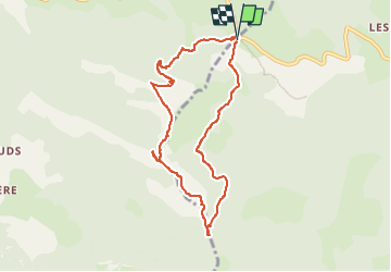
8.5 km | 18.1 km-effort
4h 0min
Yes
Trail Walking Lus-la-Croix-Haute - Pointe Feuillette - Photo
Walking
Marco05

Walking

Difficult
Lus-la-Croix-Haute, Auvergne-Rhône-Alpes, Drôme, France
10.5 km | 20 km-effort
4h 36min
Yes
Trail Walking Lus-la-Croix-Haute - Pointe feuillette  - Photo
Walking
ajd26

Walking

Medium
Lus-la-Croix-Haute, Auvergne-Rhône-Alpes, Drôme, France
11.4 km | 21 km-effort
4h 52min
Yes
Trail Walking Glandage - 2022-09-05_12h23m25_Le Jocou-col de Seysse 12km.gpx (2).xml - Photo
Walking
chancha

Walking

Very difficult
Glandage, Auvergne-Rhône-Alpes, Drôme, France
11.6 km | 24 km-effort
5h 27min
Yes


Close
My subscriptions