Trail Walking La Bégude-de-Mazenc - 26 La Bégude-de-Mazenc Saoû en 4 étapes - Photo

26 La Bégude-de-Mazenc Saoû en 4 étapes

 Maryma
Maryma

User

© OpenStreetMap contributors
Length
Length
72 km
Max alt
Max alt
1569 m
Uphill gradient
Uphill gradient
3113 m
Km-Effort
Km-Effort  
113 km
Min alt
Min alt
218 m
Downhill gradient
Downhill gradient
3006 m
Boucle
Boucle
No
Creation date :
2024-07-26 14:58:39.14
Updated on :
2024-08-05 16:34:58.683

(0 Reviews)

Walking
Walking
25h40
Difficulty : Very difficult

Scan this QR Code to open this trail in the SityTrail application

FREE GPS app for hiking

Logo SityTrail SityTrail

IGN / Geographical institutes

Download SityTrail from the App Store Download SityTrail from Google Play

Logo SityTrail SityTrail World

The world is yours!

Download SityTrail from the App Store Download SityTrail from Google Play Download SityTrail on Huawei AppGallery

About

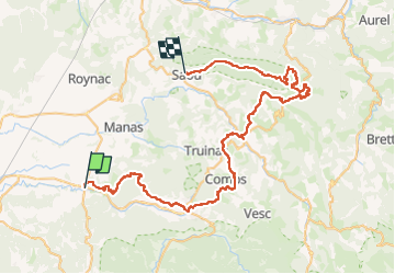
Trail Walking of 72 km to be discovered at Auvergne-Rhône-Alpes, Drôme, La Bégude-de-Mazenc. This trail is proposed by Maryma.

Description

Itinérance sur 4 étapes
J1 La Bégude - Le Poët Laval : 13 km 600D
J2 Le Poët - Dieulefit - Bourdeaux : 21,500 Km 680D
J3 Bourdeaux - La Chaudière : 14, 500 km 800D
J4 La Chaudière par les sommets des 3 Becs - Saoû : 22,800 km 1200D
Itinéraire sur GRP, GR9, GR965 et sentier des Hugunots entre lavandes, vignes et villages pittoresques, Le Poët-Laval, Dieulefit Saoû, avec la fameuse ascension terminale des 3 Becs (Veyou, Signal et Roche-Courbe).
Des hébergements à chaque arrivée d'étape;

Elevation profile

Positioning

Country:
France
Region :
Auvergne-Rhône-Alpes
Department/Province :
Drôme
Municipality :
La Bégude-de-Mazenc
Location:
Unknown
Start:(UTM)
653705 ; 4934198 (31T) N.

Trails nearby

Trail Walking Portes-en-Valdaine - 2022-10-01_17h32m32_13243364-1 - Photo
Walking
GUIDE
chancha

Walking

Medium
(1)
Portes-en-Valdaine, Auvergne-Rhône-Alpes, Drôme, France
9.8 km | 13.6 km-effort
3h 2min
Yes
Trail Walking Portes-en-Valdaine - Portes-en-Valdaine Serre-de-Mirabel 11km. - Photo
Walking
GUIDE
chancha

Walking

Difficult
(1)
Portes-en-Valdaine, Auvergne-Rhône-Alpes, Drôme, France
10.8 km | 14.7 km-effort
3h 20min
Yes
Trail Walking Saint-Gervais-sur-Roubion - 2022-10-01_17h25m59_GPX-Moutette-St-Rome-STGervais - Photo
Walking
GUIDE
chancha

Walking

Medium
(1)
Saint-Gervais-sur-Roubion, Auvergne-Rhône-Alpes, Drôme, France
9.9 km | 11.9 km-effort
2h 43min
Yes
Trail Walking Portes-en-Valdaine - GPX-Rando-Plaine-Portoise-nouvelleversion - Photo
Walking
GUIDE
thonyc

Walking

Easy
(1)
Portes-en-Valdaine, Auvergne-Rhône-Alpes, Drôme, France
7.1 km | 8.2 km-effort
2h 0min
Yes
Trail Walking La Touche - La Touche Crêtes de l'ysard 12km. - Photo
Walking
GUIDE
chancha

Walking

Difficult
(1)
La Touche, Auvergne-Rhône-Alpes, Drôme, France
12.1 km | 16.8 km-effort
3h 48min
Yes
Trail Walking La Bégude-de-Mazenc - 2022-12-16_08h55m45_tmpWriteApidae_269688_fr-1 - Photo
Walking
GUIDE
chancha

Walking

Difficult
La Bégude-de-Mazenc, Auvergne-Rhône-Alpes, Drôme, France
8.3 km | 12.3 km-effort
2h 44min
Yes
Trail Walking La Touche - La Touche : Les Citelles et Serre Pointu 12km - Photo
Walking
GUIDE
chancha

Walking

Difficult
La Touche, Auvergne-Rhône-Alpes, Drôme, France
12 km | 16.6 km-effort
4h 3min
Yes
Trail Walking La Touche - La Touche Mastaize 9km - Photo
Walking
GUIDE
chancha

Walking

Difficult
La Touche, Auvergne-Rhône-Alpes, Drôme, France
8.6 km | 10.7 km-effort
3h 24min
Yes
Trail Walking Portes-en-Valdaine - 26 portes en valdaine - Photo
Walking
GUIDE
randodyssée

Walking

Very easy
Portes-en-Valdaine, Auvergne-Rhône-Alpes, Drôme, France
10.6 km | 14.5 km-effort
4h 10min
Yes


Close
My subscriptions