![](/images/other/stat-length.png)
![Trail Walking Orelle - 73 Maurienne Francoz Bonvillard Turraz Plan Py ND des Neiges Rochecombe - Photo](https://media.geolcdn.com/t/1900/400/a86dc9d2-69f2-418a-9ddc-2594b82c3f81.jpg&format=pjpeg&maxdim=2)
73 Maurienne Francoz Bonvillard Turraz Plan Py ND des Neiges Rochecombe
Maryma
User
![Length](/images/other/stat-length.png)
![Max alt](https://static1.geolcdn.com/siteimages/upload/files/1508320355ic_sort_altitude_max_24dp.png)
![Uphill gradient](https://static1.geolcdn.com/siteimages/upload/files/1508320355ic_sort_den_pos_24dp.png)
![Km-Effort](/images/other/stat-length.png)
![Min alt](https://static1.geolcdn.com/siteimages/upload/files/1508320355ic_sort_altitude_min_24dp.png)
![Downhill gradient](https://static1.geolcdn.com/siteimages/upload/files/1508320355ic_sort_den_neg_24dp.png)
![Boucle](https://static1.geolcdn.com/siteimages/upload/files/16400158638029165_repeat_loop_refresh_sync_direction_icon.png)
![Walking](https://static1.geolcdn.com/sitytour/trail-icons/101.png)
7h22
Difficulty : Very difficult
![Scan this QR Code to open this trail in the SityTrail application](https://capi.geolives.com/qq0zvz2zws4bq2lad0pu/sitytour/trails/4133218/qr.png?size=200)
FREE GPS app for hiking
About
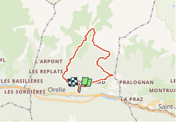
Trail Walking of 14.6 km to be discovered at Auvergne-Rhône-Alpes, Savoy, Orelle. This trail is proposed by Maryma.
Description
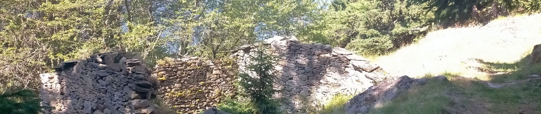
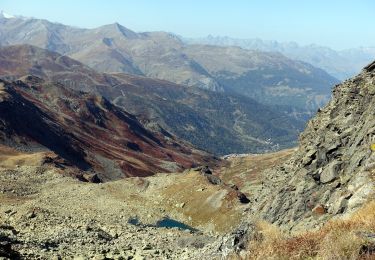
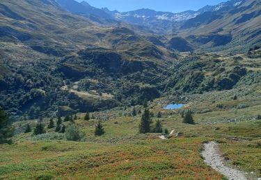
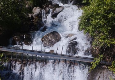
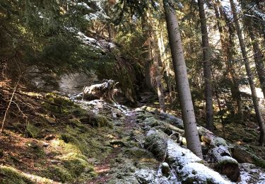
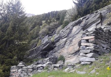
Un départ assez raide par un joli chemin qui traverse le Teppey et Bonvillard. De là, on continue à monter jusqu'au hameau en ruines de Turraz. Bifurcation jusqu'à Précourt. Le chemin se fait plus incertain et grimpe sec jusqu'aux Arponnets puis les Chamoussières. Là, on quitte les sous-bois, pour trouver de la prairie et une traversée dans des passages rocheux jusqu'à Plan Py. Une vue en plongée sur le Chapelle ND des Anges. Rapidement on retrouve un chemin en forêt. Ne pas manquer de tourner à gauche, direction Rochecombe. Prénadiua présente un passage sous un éboulis rocheux. Enfin, on traverse le hameau de Fusine. Il ne faut pas manquer de faire quelques pas supplémentaires pour admirer la Chapelle Saint-François d'Assise. On peut admirer l'intérieur à travers une grille. Retour sur nos pas pour continuer par l'impressionnante cascade de Bonrieu. Enfin, on reprend le chemin de l'aller pour retrouver Francoz, le parking des Eaux d'Orelle.
Magnifique parcours en forêt la plupart du temps. On traverse beaucoup de hameaux en ruines. Vue sur le barrage de Bissorte, puis le col du Bouchet et le Cime de Caron. On passe sous le télécabine des Trois Vallées. Dommage que la chapelle ND des Anges soit fermée. On y trouve un refuge refait récemment.
Parcours agréable. La descente se fait tout en douceur sur un terrain très souple et absolument pas glissant. le plus gros de l'effort se fait le long de la conduite forcée, après Précourt et jusqu'aux Arponnets.
Positioning
Comments
Trails nearby
![Trail Touring skiing Valmeinier - la roche du lac, le col des marches et remonter en bas de l'arête de Petit Fourchon - Photo](https://media.geolcdn.com/t/375/260/2c1cd63c-1529-49ee-9858-ec4bc64019bc.jpg&format=jpg&maxdim=2)
![Touring skiing Touring skiing](https://static1.geolcdn.com/sitytour/trail-icons/503.png)
Touring skiing
![](/images/other/stat-length.png)
![](https://static1.geolcdn.com/siteimages/upload/files/16400158638029165_repeat_loop_refresh_sync_direction_icon.png)
![Trail Walking Valmeinier - Valmeinier 1800 Lac Vert - Photo](https://media.geolcdn.com/t/375/260/ext.jpg?maxdim=2&url=https%3A%2F%2Fstatic1.geolcdn.com%2Fsiteimages%2Fupload%2Ffiles%2F1553511878bg_sport_marche.png)
![Walking Walking](https://static1.geolcdn.com/sitytour/trail-icons/101.png)
Walking
![](/images/other/stat-length.png)
![](https://static1.geolcdn.com/siteimages/upload/files/16400158638029165_repeat_loop_refresh_sync_direction_icon.png)
![Snowshoes Snowshoes](https://static1.geolcdn.com/sitytour/trail-icons/504.png)
Snowshoes
![](/images/other/stat-length.png)
![](https://static1.geolcdn.com/siteimages/upload/files/16400158638029165_repeat_loop_refresh_sync_direction_icon.png)
![Walking Walking](https://static1.geolcdn.com/sitytour/trail-icons/101.png)
Walking
![](/images/other/stat-length.png)
![](https://static1.geolcdn.com/siteimages/upload/files/16400158638029165_repeat_loop_refresh_sync_direction_icon.png)
![Trail Walking Valmeinier - Colerieux- lac vert - refuge terres rouges- grands lacs - Photo](https://media.geolcdn.com/t/375/260/c5a97f83-364a-46fa-974c-12bf93870cec.jpg&format=jpg&maxdim=2)
![Walking Walking](https://static1.geolcdn.com/sitytour/trail-icons/101.png)
Walking
![](/images/other/stat-length.png)
![](https://static1.geolcdn.com/siteimages/upload/files/16400158638029165_repeat_loop_refresh_sync_direction_icon.png)
![Trail Walking Valmeinier - Valmeinier-Lac de Curtalès - Photo](https://media.geolcdn.com/t/375/260/ext.jpg?maxdim=2&url=https%3A%2F%2Fstatic1.geolcdn.com%2Fsiteimages%2Fupload%2Ffiles%2F1553511878bg_sport_marche.png)
![Walking Walking](https://static1.geolcdn.com/sitytour/trail-icons/101.png)
Walking
![](/images/other/stat-length.png)
![](https://static1.geolcdn.com/siteimages/upload/files/16400158638029165_repeat_loop_refresh_sync_direction_icon.png)
![Trail Walking Valmeinier - Valmeinier - Photo](https://media.geolcdn.com/t/375/260/a4d521ae-cdec-42a4-bd02-1c58bda72e20.jpg&format=jpg&maxdim=2)
![Walking Walking](https://static1.geolcdn.com/sitytour/trail-icons/101.png)
Walking
![](/images/other/stat-length.png)
![](https://static1.geolcdn.com/siteimages/upload/files/16400158638029165_repeat_loop_refresh_sync_direction_icon.png)
![Trail Walking Orelle - parking edf vers Bissorte arrêt les Cartillères - Photo](https://media.geolcdn.com/t/375/260/80b9b62b-cb31-4ac9-87c8-19344c2d8ef0.jpg&format=jpg&maxdim=2)
![Walking Walking](https://static1.geolcdn.com/sitytour/trail-icons/101.png)
Walking
![](/images/other/stat-length.png)
![](https://static1.geolcdn.com/siteimages/upload/files/16400158638029165_repeat_loop_refresh_sync_direction_icon.png)
![Trail Walking Saint-André - Pralognan - Plan du Clos - Photo](https://media.geolcdn.com/t/375/260/5ea4ee6f-d364-4747-b256-0a27656a1831.jpg&format=jpg&maxdim=2)
![Walking Walking](https://static1.geolcdn.com/sitytour/trail-icons/101.png)
Walking
![](/images/other/stat-length.png)
![](https://static1.geolcdn.com/siteimages/upload/files/16400158638029165_repeat_loop_refresh_sync_direction_icon.png)