![](/images/other/stat-length.png)
![Trail Walking Soultz-Haut-Rhin - SityTrail - Croix Zimmermann_Goldbach Sapinière - Photo](https://media.geolcdn.com/t/1900/400/ext.pjpeg?maxdim=2&url=https%3A%2F%2Fstatic1.geolcdn.com%2Fsiteimages%2Fupload%2Ffiles%2F1553511878bg_sport_marche.png)
SityTrail - Croix Zimmermann_Goldbach Sapinière
E.BURCK
User
![Length](/images/other/stat-length.png)
![Max alt](https://static1.geolcdn.com/siteimages/upload/files/1508320355ic_sort_altitude_max_24dp.png)
![Uphill gradient](https://static1.geolcdn.com/siteimages/upload/files/1508320355ic_sort_den_pos_24dp.png)
![Km-Effort](/images/other/stat-length.png)
![Min alt](https://static1.geolcdn.com/siteimages/upload/files/1508320355ic_sort_altitude_min_24dp.png)
![Downhill gradient](https://static1.geolcdn.com/siteimages/upload/files/1508320355ic_sort_den_neg_24dp.png)
![Boucle](https://static1.geolcdn.com/siteimages/upload/files/16400158638029165_repeat_loop_refresh_sync_direction_icon.png)
![Walking](https://static1.geolcdn.com/sitytour/trail-icons/101.png)
3h31
Difficulty : Medium
![Scan this QR Code to open this trail in the SityTrail application](https://capi.geolives.com/qq0zvz2zws4bq2lad0pu/sitytour/trails/4131508/qr.png?size=200)
FREE GPS app for hiking
About
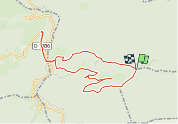
Trail Walking of 9.8 km to be discovered at Grand Est, Haut-Rhin, Soultz-Haut-Rhin. This trail is proposed by E.BURCK.
Description
Une balade vers l'auberge de la Sapinière au dessus de Goldbach :
Croix Zimmermann- Fort Baratin- chapelle Sicurani- col Amic - Sapinière -puis retour par le Kaltenbach.
Dénivelé de 390 m le matin et 35 m l'après midi sur 10 km au total.
ACCÈS :
Par Soultz en direction de Jungholz, à la sortie de Soultz à l'embranchement obliquer à gauche en direction du Col Amic. Passer le camping de la Sapinière, la Croix Zimmermann est environ à 1 km sur votre gauche.
PARKING :
- parking de la croix Zimmermann.
47.873480, 7.158343 ou
N 47°52'24", E 7°09'30"
HEURE DE RENDEZ VOUS :
9h30
RESTAURATION:
Auberge La Sapinière à Goldbach
Tél: 03 89 28 47 18
Positioning
Comments
Trails nearby
![Trail Walking Soultz-Haut-Rhin - Hartmannswillerkopf - Circuit découverte - Photo](https://media.geolcdn.com/t/375/260/ext.jpg?maxdim=2&url=https%3A%2F%2Fservices.sitytrail.com%2FGeolivesWS%2FDownloadMedia.ashx%3FTrailID%3D422294%26Media%3Dfix__20150517124954.jpg)
![Walking Walking](https://static1.geolcdn.com/sitytour/trail-icons/101.png)
Walking
![](/images/other/stat-length.png)
![](https://static1.geolcdn.com/siteimages/upload/files/16400158638029165_repeat_loop_refresh_sync_direction_icon.png)
![Trail Walking Soultz-Haut-Rhin - Hartmannswillerkopf - Circuit anneau bleu - Photo](https://media.geolcdn.com/t/375/260/ext.jpg?maxdim=2&url=https%3A%2F%2Fservices.sitytrail.com%2FGeolivesWS%2FDownloadMedia.ashx%3FTrailID%3D422291%26Media%3Dfix__20150517150228.jpg)
![Walking Walking](https://static1.geolcdn.com/sitytour/trail-icons/101.png)
Walking
![](/images/other/stat-length.png)
![](https://static1.geolcdn.com/siteimages/upload/files/16400158638029165_repeat_loop_refresh_sync_direction_icon.png)
![Trail Other activity Steinbach - lac du ballon - Photo](https://media.geolcdn.com/t/375/260/ext.jpg?maxdim=2&url=https%3A%2F%2Fservices.sitytrail.com%2FGeolivesWS%2FDownloadMedia.ashx%3FTrailID%3D210434%26Media%3Dfix__20130805111422.jpg)
![Other activity Other activity](https://static1.geolcdn.com/sitytour/trail-icons/900.png)
Other activity
![](/images/other/stat-length.png)
![](https://static1.geolcdn.com/siteimages/upload/files/16400158638029165_repeat_loop_refresh_sync_direction_icon.png)
![Trail On foot Goldbach-Altenbach - Firstacker - Willer sur Thur - Photo](https://media.geolcdn.com/t/375/260/203caa2b-07d7-4c6d-9f37-990a5db6b7c9.jpeg&format=jpg&maxdim=2)
![On foot On foot](https://static1.geolcdn.com/sitytour/trail-icons/100.png)
On foot
![](/images/other/stat-length.png)
![](https://static1.geolcdn.com/siteimages/upload/files/16400158638029165_repeat_loop_refresh_sync_direction_icon.png)
![Trail Trail Wattwiller - The History Ultra - stage 1 - Photo](https://media.geolcdn.com/t/375/260/ext.jpg?maxdim=2&url=https%3A%2F%2Fstatic1.geolcdn.com%2Fsiteimages%2Fupload%2Ffiles%2F1524743154running.jpg)
![Trail Trail](https://static1.geolcdn.com/sitytour/trail-icons/104.png)
Trail
![](/images/other/stat-length.png)
![](https://static1.geolcdn.com/siteimages/upload/files/16400158638029165_repeat_loop_refresh_sync_direction_icon.png)
![Trail Walking Willer-sur-Thur - Spechtfest2025 - Photo](https://media.geolcdn.com/t/375/260/5eafed01-1af1-4202-ab8a-aebd0d9b1194.jpg&format=jpg&maxdim=2)
![Walking Walking](https://static1.geolcdn.com/sitytour/trail-icons/101.png)
Walking
![](/images/other/stat-length.png)
![](https://static1.geolcdn.com/siteimages/upload/files/16400158638029165_repeat_loop_refresh_sync_direction_icon.png)
![Trail Walking Soultz-Haut-Rhin - Rando Marcheurs..04/04_2025 - Photo](https://media.geolcdn.com/t/375/260/2ab5dad5-2554-412a-abd7-9d4222ed2a04.jpg&format=jpg&maxdim=2)
![Walking Walking](https://static1.geolcdn.com/sitytour/trail-icons/101.png)
Walking
![](/images/other/stat-length.png)
![](https://static1.geolcdn.com/siteimages/upload/files/16400158638029165_repeat_loop_refresh_sync_direction_icon.png)
![Trail Walking Jungholtz - Rando Retrouvailles...01/03/2024.par Jean Marc - Photo](https://media.geolcdn.com/t/375/260/a9ee6325-7504-4fd2-a0fe-1e1c5b8164cc.jpg&format=jpg&maxdim=2)
![Walking Walking](https://static1.geolcdn.com/sitytour/trail-icons/101.png)
Walking
![](/images/other/stat-length.png)
![](https://static1.geolcdn.com/siteimages/upload/files/16400158638029165_repeat_loop_refresh_sync_direction_icon.png)
![Walking Walking](https://static1.geolcdn.com/sitytour/trail-icons/101.png)
Walking
![](/images/other/stat-length.png)
![](https://static1.geolcdn.com/siteimages/upload/files/16400158638029165_repeat_loop_refresh_sync_direction_icon.png)