Trail Walking Collias - De Collias à la chapelle Sainte-Vérédème - Photo

De Collias à la chapelle Sainte-Vérédème

© OpenStreetMap contributors
Length
Length
12.6 km
Max alt
Max alt
180 m
Uphill gradient
Uphill gradient
270 m
Km-Effort
Km-Effort  
16.2 km
Min alt
Min alt
30 m
Downhill gradient
Downhill gradient
273 m
Boucle
Boucle
Yes
Creation date :
2024-07-22 07:47:58.085
Updated on :
2024-07-30 08:02:09.673

(0 Reviews)

Walking
Walking
3h41
Difficulty : Difficult

Scan this QR Code to open this trail in the SityTrail application

FREE GPS app for hiking

Logo SityTrail SityTrail

IGN / Geographical institutes

Download SityTrail from the App Store Download SityTrail from Google Play

Logo SityTrail SityTrail World

The world is yours!

Download SityTrail from the App Store Download SityTrail from Google Play Download SityTrail on Huawei AppGallery

About

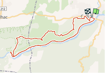
Trail Walking of 12.6 km to be discovered at Occitania, Gard, Collias. This trail is proposed by bececoste.

Description

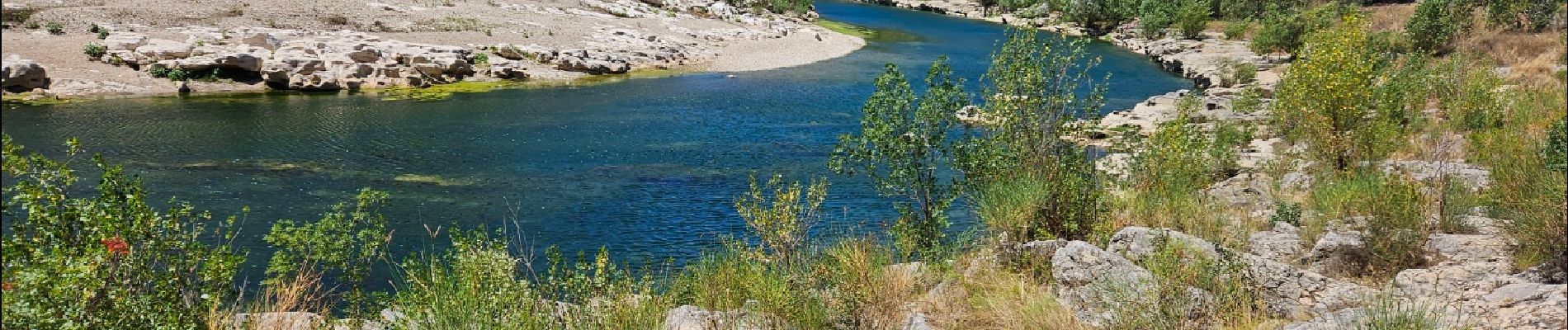
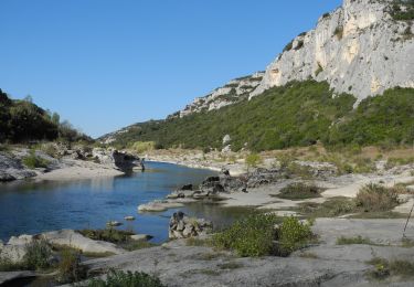
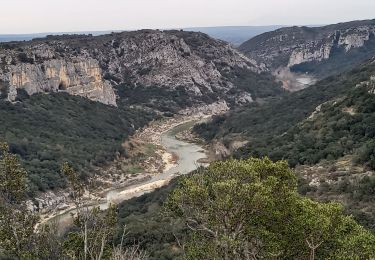
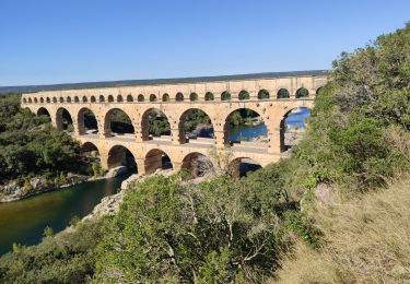
Boucle qui comporte trois types de paysage complètement différents. Tout d'abord, la première partie s'effectuera sur le plateau au cours duquel on aura un accès à un beau point de vue en haut de falaise sur le Gardon et le paysage alentour.
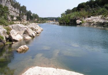
Une deuxième partie constituera la forte descente vers la rive du Gardon et les jolies vues dont on profitera tout au cours de cette descente.
Et enfin, le retour se fera en suivant la rive gauche du Gardon et ce après avoir fait un aller-retour vers le moulin et la chapelle

Elevation profile

Photos

Positioning

Country:
France
Region :
Occitania
Department/Province :
Gard
Municipality :
Collias
Location:
Unknown
Start:(UTM)
618739 ; 4867790 (31T) N.

Trails nearby

Trail Walking Vers-Pont-du-Gard - Rando pont du Gard - Photo
Walking
SabetMick

Walking

Easy
(1)
Vers-Pont-du-Gard, Occitania, Gard, France
6.8 km | 8.6 km-effort
2h 49min
No
Trail Walking Argilliers - Les Darbounelles - Argilliers - Photo
Walking
tracegps

Walking

Medium
(1)
Argilliers, Occitania, Gard, France
11.4 km | 13.9 km-effort
3h 0min
Yes
Trail Running Saint-Maximin - St-Maximin et la vallée d'Eure - Photo
Running
tracegps

Running

Medium
(1)
Saint-Maximin, Occitania, Gard, France
18 km | 23 km-effort
2h 0min
Yes
Trail Walking Collias - La Baume par Collias - Photo
Walking
tracegps

Walking

Medium
(3)
Collias, Occitania, Gard, France
13.3 km | 18.1 km-effort
4h 0min
Yes
Trail Walking Collias - PF-Collias - Les Gorges du Gardon - Photo
Walking
MicDul

Walking

Easy
(1)
Collias, Occitania, Gard, France
12.9 km | 16.4 km-effort
3h 39min
Yes
Trail Walking Poulx - Balcon sur Gorges du Gardon - Photo
Walking
GUIDE
nadinebondoux

Walking

Medium
Poulx, Occitania, Gard, France
17.2 km | 22 km-effort
5h 16min
Yes
Trail On foot Collias - L'Ermitage de Collias - Photo
On foot
GUIDE+

On foot

Easy
Collias, Occitania, Gard, France
5.3 km | 7 km-effort
1h 35min
No
Trail Walking Vers-Pont-du-Gard - Vers-pont-du-gard panorama-dfci - Photo
Walking
rando30129

Walking

Medium
(2)
Vers-Pont-du-Gard, Occitania, Gard, France
9.4 km | 11.5 km-effort
2h 31min
Yes
Trail Walking Cabrières - 30 gardon bois des coufines - Photo
Walking
GUIDE
randodyssée

Walking

Easy
Cabrières, Occitania, Gard, France
11.4 km | 15.6 km-effort
4h 30min
No


Close
My subscriptions