Trail Walking Ouches - Ouches-Les Durands - Photo
 Jgar
Jgar

User

© OpenStreetMap contributors
Length
Length
11.1 km
Max alt
Max alt
389 m
Uphill gradient
Uphill gradient
98 m
Km-Effort
Km-Effort  
12.4 km
Min alt
Min alt
317 m
Downhill gradient
Downhill gradient
98 m
Boucle
Boucle
Yes
Creation date :
2024-07-22 06:22:15.0
Updated on :
2024-07-22 14:52:01.823

(0 Reviews)

Walking
Walking
2h48
Difficulty : Difficult

Scan this QR Code to open this trail in the SityTrail application

FREE GPS app for hiking

Logo SityTrail SityTrail

IGN / Geographical institutes

Download SityTrail from the App Store Download SityTrail from Google Play

Logo SityTrail SityTrail World

The world is yours!

Download SityTrail from the App Store Download SityTrail from Google Play Download SityTrail on Huawei AppGallery

About

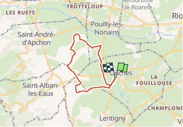
Trail Walking of 11.1 km to be discovered at Auvergne-Rhône-Alpes, Loire, Ouches. This trail is proposed by Jgar.

Description

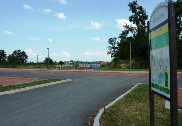
Se garer au parking situé au sud-sud-est de l'école.
Cette petite balade n'offre aucune difficulté, si ce n'est sa relative longueur pour des jambes jeunes ou des personnes âgées.

Elevation profile

Photos

Positioning

Country:
France
Region :
Auvergne-Rhône-Alpes
Department/Province :
Loire
Municipality :
Ouches
Location:
Unknown
Start:(UTM)
576371 ; 5096081 (31T) N.

Trails nearby

Trail Walking Riorges - variante pr12 les ecureuils - Photo
Walking
famillerudent

Walking

Easy
(1)
Riorges, Auvergne-Rhône-Alpes, Loire, France
8 km | 9.2 km-effort
3h 8min
Yes
Trail Walking Villemontais - Villemontais : Chérier et Haut Ste-Agathe - Photo
Walking
Jgar

Walking

Difficult
Villemontais, Auvergne-Rhône-Alpes, Loire, France
15.1 km | 23 km-effort
4h 22min
Yes
Trail Walking Ouches - Ouches : de la plaine à la côte roannaise  - Photo
Walking
Jgar

Walking

Medium
Ouches, Auvergne-Rhône-Alpes, Loire, France
15.4 km | 21 km-effort
4h 37min
Yes
Trail Walking Saint-André-d'Apchon - St-André-d'Apchon-Rocher de Bellevue - Photo
Walking
Jgar

Walking

Medium
Saint-André-d'Apchon, Auvergne-Rhône-Alpes, Loire, France
11 km | 17.1 km-effort
4h 16min
Yes
Trail Walking Saint-Alban-les-Eaux - Saint Alban les Eaux - Photo
Walking
jpc42

Walking

Medium
Saint-Alban-les-Eaux, Auvergne-Rhône-Alpes, Loire, France
13.1 km | 19.5 km-effort
3h 10min
Yes
Trail Walking Renaison - Renaison: entre plaine et côte Roannaise - Photo
Walking
jpc42

Walking

Easy
Renaison, Auvergne-Rhône-Alpes, Loire, France
12.4 km | 14 km-effort
3h 5min
Yes
Trail Mountain bike Lentigny - Escapade dans les Gouttes de la Loire - Lentigny - Photo
Mountain bike
tracegps

Mountain bike

Difficult
Lentigny, Auvergne-Rhône-Alpes, Loire, France
31 km | 40 km-effort
3h 0min
Yes
Trail Mountain bike Villerest - Les Gorges de la Loire et la Gorge du Lourdon - Villerest-Champlong - Photo
Mountain bike
tracegps

Mountain bike

Medium
Villerest, Auvergne-Rhône-Alpes, Loire, France
19.2 km | 23 km-effort
2h 0min
Yes
Trail Mountain bike Saint-Jean-Saint-Maurice-sur-Loire - 3ème Rando VTT de la Tour (ACLT) - Saint-Jean-Saint-Maurice-sur-Loire - Photo
Mountain bike
tracegps

Mountain bike

Difficult
Saint-Jean-Saint-Maurice-sur-Loire, Auvergne-Rhône-Alpes, Loire, France
28 km | 36 km-effort
3h 0min
Yes


Close
My subscriptions