Trail Walking Saint-Paul-sur-Ubaye - Tour du Chambeyron en 5 jours - Photo
© OpenStreetMap contributors
Length
Length
84 km
Max alt
Max alt
3121 m
Uphill gradient
Uphill gradient
5589 m
Km-Effort
Km-Effort  
158 km
Min alt
Min alt
1435 m
Downhill gradient
Downhill gradient
5586 m
Boucle
Boucle
Yes
Creation date :
2024-07-21 16:15:18.828
Updated on :
2024-07-21 16:39:28.58

(0 Reviews)

Walking
Walking
35h59
Difficulty : Very difficult

Scan this QR Code to open this trail in the SityTrail application

FREE GPS app for hiking

Logo SityTrail SityTrail

IGN / Geographical institutes

Download SityTrail from the App Store Download SityTrail from Google Play

Logo SityTrail SityTrail World

The world is yours!

Download SityTrail from the App Store Download SityTrail from Google Play Download SityTrail on Huawei AppGallery

About

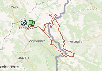
Trail Walking of 84 km to be discovered at Provence-Alpes-Côte d'Azur, Alpes-de-Haute-Provence, Saint-Paul-sur-Ubaye. This trail is proposed by Camille Lecoutre 3.

Description

Bivouac au Lac de Roburent
Bivouac au Lac de Visaisa
Bivouac au Lac de Marinet
Bivouac au Lac Premier
Navettes gratuites (2 navettes par jour, 3 jours par semaine, lundi, jeudi, samedi) depuis Barcelonnette, elle-même accessible en bus depuis la gare de Gap.

Elevation profile

Points of interest

Point of interest Argentera - Arrivée Jour 1 - Photo
Camille Lecoutre 3
ARGENTERA 
Point of interest Acceglio - Arrivée Jour 2 - Photo
Camille Lecoutre 3
ACCEGLIO 
Point of interest Saint-Paul-sur-Ubaye - Arrivée Jour 3 - Photo
Camille Lecoutre 3
SAINT-PAUL-SUR-UBAYE 
Point of interest Saint-Paul-sur-Ubaye - Arrivée Jour 4 - Photo
Camille Lecoutre 3
SAINT-PAUL-SUR-UBAYE 

Positioning

Country:
France
Region :
Provence-Alpes-Côte d'Azur
Department/Province :
Alpes-de-Haute-Provence
Municipality :
Saint-Paul-sur-Ubaye
Location:
Unknown
Start:(Dec)
Start:(UTM)
321779 ; 4931634 (32T) N.

Trails nearby

Trail Walking Val-d'Oronaye - Saint Ours - Plateau de Mallemort - Photo
Walking
Coqorico

Walking

Very easy
(2)
Val-d'Oronaye, Provence-Alpes-Côte d'Azur, Alpes-de-Haute-Provence, France
10.4 km | 15.4 km-effort
1h 49min
Yes
Trail Walking Vars - boucle col de Vars  - Photo
Walking
marmotte83

Walking

Easy
(2)
Vars, Provence-Alpes-Côte d'Azur, Hautes-Alpes, France
4.5 km | 6.1 km-effort
2h 39min
Yes
Trail Walking Val-d'Oronaye - Fort de Rochecroix PR43 - Photo
Walking
ged94

Walking

Medium
(1)
Val-d'Oronaye, Provence-Alpes-Côte d'Azur, Alpes-de-Haute-Provence, France
10.1 km | 18.2 km-effort
6h 13min
No
Trail Walking Vars - Tête de Paneyron - Col de Vars - Photo
Walking
tracegps

Walking

Difficult
(1)
Vars, Provence-Alpes-Côte d'Azur, Hautes-Alpes, France
10 km | 19 km-effort
3h 0min
Yes
Trail Walking Saint-Paul-sur-Ubaye - pointe de l'Eyssina  - Photo
Walking
GUIDE
orsel

Walking

Medium
Saint-Paul-sur-Ubaye, Provence-Alpes-Côte d'Azur, Alpes-de-Haute-Provence, France
8.7 km | 18 km-effort
6h 54min
No
Trail Other activity Saint-Paul-sur-Ubaye - massour  - Photo
Other activity
Sandrine1

Other activity

Medium
(1)
Saint-Paul-sur-Ubaye, Provence-Alpes-Côte d'Azur, Alpes-de-Haute-Provence, France
6.1 km | 19.3 km-effort
3h 19min
No
Trail Walking Saint-Paul-sur-Ubaye - Lac des 9 couleurs - Photo
Walking
andre06130

Walking

Medium
(1)
Saint-Paul-sur-Ubaye, Provence-Alpes-Côte d'Azur, Alpes-de-Haute-Provence, France
17.4 km | 31 km-effort
6h 15min
Yes
Trail Walking Val-d'Oronaye - fort roche la croix - Photo
Walking
rvmp

Walking

Easy
(1)
Val-d'Oronaye, Provence-Alpes-Côte d'Azur, Alpes-de-Haute-Provence, France
13.6 km | 23 km-effort
7h 11min
Yes
Trail Electric bike Vars - Vars  - Photo
Electric bike
Yves Locati

Electric bike

Medium
Vars, Provence-Alpes-Côte d'Azur, Hautes-Alpes, France
34 km | 50 km-effort
2h 59min
Yes


Close
My subscriptions