Trail Walking Raismes - Mare à Goriaux - Photo

Mare à Goriaux

 Greg813
Greg813

User

© OpenStreetMap contributors
Length
Length
21 km
Max alt
Max alt
38 m
Uphill gradient
Uphill gradient
145 m
Km-Effort
Km-Effort  
23 km
Min alt
Min alt
12 m
Downhill gradient
Downhill gradient
145 m
Boucle
Boucle
Yes
Creation date :
2024-07-21 07:24:05.099
Updated on :
2024-07-21 17:00:05.605

(0 Reviews)

Walking
Walking
4h28
Difficulty : Medium

Scan this QR Code to open this trail in the SityTrail application

FREE GPS app for hiking

Logo SityTrail SityTrail

IGN / Geographical institutes

Download SityTrail from the App Store Download SityTrail from Google Play

Logo SityTrail SityTrail World

The world is yours!

Download SityTrail from the App Store Download SityTrail from Google Play Download SityTrail on Huawei AppGallery

About

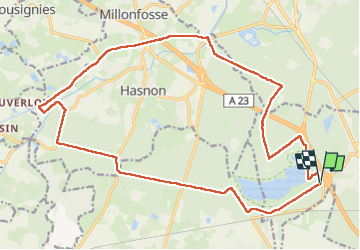
Trail Walking of 21 km to be discovered at Hauts-de-France, Nord, Raismes. This trail is proposed by Greg813.

Description

Au départ de la mare à Goriaux, randonnée dans le parc naturel régional avant d'aller longer la Scarpe pour renvenir vers le lac.

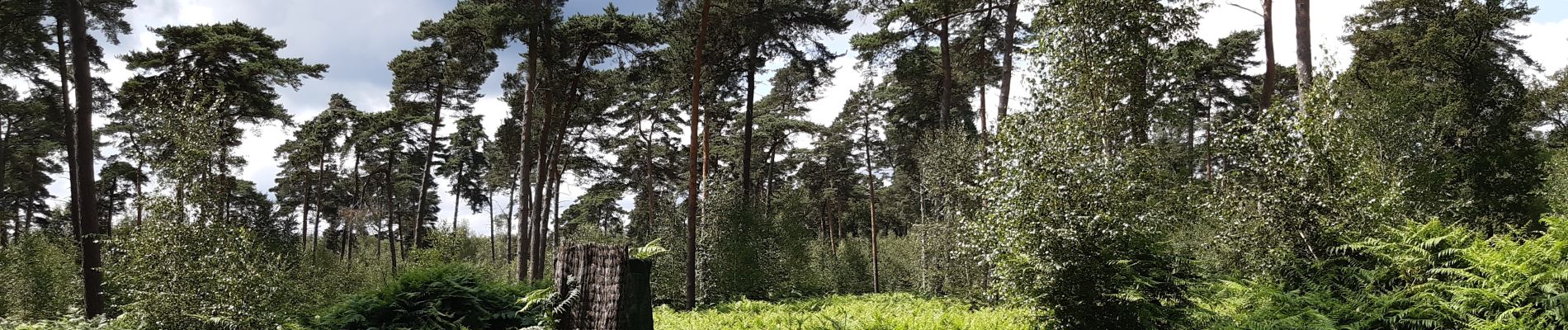
Finalement peu adapté à la randonnée pédestre, mais c'est un spot idéal pour du vélo !

Elevation profile

Photos

Positioning

Country:
France
Region :
Hauts-de-France
Department/Province :
Nord
Municipality :
Raismes
Location:
Unknown
Start:(UTM)
531807 ; 5582746 (31U) N.

Trails nearby

Trail Walking Raismes - Circuit du Terril de Sabatier - Photo
Walking
corsinou

Walking

Easy
(1)
Raismes, Hauts-de-France, Nord, France
13 km | 14.9 km-effort
2h 34min
Yes
Trail Walking Saint-Amand-les-Eaux - terril vicoigne - Photo
Walking
papiou

Walking

Easy
(1)
Saint-Amand-les-Eaux, Hauts-de-France, Nord, France
8.7 km | 9.7 km-effort
2h 0min
Yes
Trail Walking Saint-Amand-les-Eaux - notre dame d'amour(NDA), propose par VDN - Photo
Walking
papiou

Walking

Medium
Saint-Amand-les-Eaux, Hauts-de-France, Nord, France
9.7 km | 10.6 km-effort
2h 16min
Yes
Trail Walking Raismes - variante de la course des terrils - Photo
Walking
papiou

Walking

Medium
(1)
Raismes, Hauts-de-France, Nord, France
8.8 km | 10 km-effort
2h 10min
Yes
Trail Walking Wallers - Mare goraux - Photo
Walking
xcreator

Walking

Medium
Wallers, Hauts-de-France, Nord, France
6.8 km | 7.5 km-effort
1h 32min
Yes
Trail Walking Haveluy - les pavés Bernard Hinault et pont femme à barbe  - Photo
Walking
papiou

Walking

Easy
Haveluy, Hauts-de-France, Nord, France
9.4 km | 10.1 km-effort
2h 0min
Yes
Trail Walking Wallers - tour d'Hasnon par forêt et ruisseau - Photo
Walking
papiou

Walking

Easy
Wallers, Hauts-de-France, Nord, France
9.8 km | 10.6 km-effort
2h 8min
Yes
Trail Walking Saint-Amand-les-Eaux - Mesnil, version plus longue - Photo
Walking
papiou

Walking

Easy
Saint-Amand-les-Eaux, Hauts-de-France, Nord, France
9.9 km | 11.1 km-effort
2h 2min
Yes
Trail Walking Saint-Amand-les-Eaux - Mesnil. st Amand - Photo
Walking
papiou

Walking

Easy
Saint-Amand-les-Eaux, Hauts-de-France, Nord, France
8.5 km | 9.6 km-effort
1h 28min
Yes


Close
My subscriptions