Trail Walking Rimbach-près-Masevaux - Lacs Neuweiher et des Perches depuis Rimbach - Photo

Lacs Neuweiher et des Perches depuis Rimbach

 Bart2015
Bart2015

User

© OpenStreetMap contributors
Length
Length
14 km
Max alt
Max alt
1147 m
Uphill gradient
Uphill gradient
650 m
Km-Effort
Km-Effort  
23 km
Min alt
Min alt
556 m
Downhill gradient
Downhill gradient
658 m
Boucle
Boucle
Yes
Creation date :
2024-07-18 09:14:33.108
Updated on :
2024-07-29 09:12:06.781

(0 Reviews)

Walking
Walking
5h08
Difficulty : Very difficult

Scan this QR Code to open this trail in the SityTrail application

FREE GPS app for hiking

Logo SityTrail SityTrail

IGN / Geographical institutes

Download SityTrail from the App Store Download SityTrail from Google Play

Logo SityTrail SityTrail World

The world is yours!

Download SityTrail from the App Store Download SityTrail from Google Play Download SityTrail on Huawei AppGallery

About

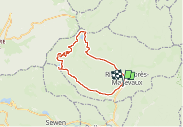
Trail Walking of 14 km to be discovered at Grand Est, Haut-Rhin, Rimbach-près-Masevaux. This trail is proposed by Bart2015.

Description

Très belle randonnée au départ de Rimbach-près-Masevaux empruntant les sentiers autorisés. Ces 2 lacs sont magnifiques et propices à la baignade. Possibilité de faire une pause à l'auberge du Neuweiher. Au détour des sentier, profitezdes belles vues plongeantes sur les lacs.
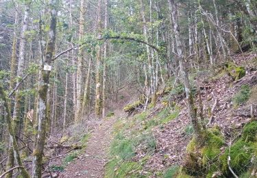
Bonne rando, soyez prudent ...

Elevation profile

Positioning

Country:
France
Region :
Grand Est
Department/Province :
Haut-Rhin
Municipality :
Rimbach-près-Masevaux
Location:
Unknown
Start:(UTM)
346523 ; 5298775 (32T) N.

Trails nearby

Trail Walking Rimbach-près-Masevaux - Haute Bers - Photo
Walking
helmut68

Walking

Medium
(1)
Rimbach-près-Masevaux, Grand Est, Haut-Rhin, France
12 km | 20 km-effort
3h 25min
Yes
Trail Walking Sewen - Boucle entre les lacs de Sewen et d'Alfeld - Photo
Walking
tracegps

Walking

Medium
(1)
Sewen, Grand Est, Haut-Rhin, France
8.1 km | 12.3 km-effort
2h 30min
Yes
Trail Walking Storckensohn - lac des perches marchettes - Photo
Walking
lacote

Walking

Medium
(1)
Storckensohn, Grand Est, Haut-Rhin, France
11.9 km | 20 km-effort
4h 8min
Yes
Trail Walking Storckensohn - 2022-07-16 Marche Auberge Gazon Vert Chapelle des Ves - Photo
Walking
GUIDE
holtzv

Walking

Very difficult
Storckensohn, Grand Est, Haut-Rhin, France
21 km | 37 km-effort
6h 11min
No
Trail Walking Rimbach-près-Masevaux - Les deux lacs - Photo
Walking
helmut68

Walking

Difficult
Rimbach-près-Masevaux, Grand Est, Haut-Rhin, France
15.5 km | 25 km-effort
5h 47min
Yes
Trail Walking Wegscheid - FucksfelsenBelacker - Photo
Walking
helmut68

Walking

Medium
Wegscheid, Grand Est, Haut-Rhin, France
14.4 km | 24 km-effort
4h 9min
Yes
Trail Walking Wegscheid - Sattelboden Stahlberg - Photo
Walking
helmut68

Walking

Very difficult
Wegscheid, Grand Est, Haut-Rhin, France
11.9 km | 20 km-effort
4h 35min
Yes
Trail Walking Wegscheid - Sortie école primaire - Rossberg - Photo
Walking
helmut68

Walking

Medium
Wegscheid, Grand Est, Haut-Rhin, France
11.8 km | 19.1 km-effort
4h 48min
Yes
Trail Walking Mollau - Le rossberg - Photo
Walking
margotte

Walking

Medium
Mollau, Grand Est, Haut-Rhin, France
14.9 km | 25 km-effort
7h 41min
Yes


Close
My subscriptions