Trail Walking Villard-de-Lans - Plateau Julien - Photo
© OpenStreetMap contributors
Length
Length
1.9 km
Max alt
Max alt
1554 m
Uphill gradient
Uphill gradient
47 m
Km-Effort
Km-Effort  
2.5 km
Min alt
Min alt
1507 m
Downhill gradient
Downhill gradient
46 m
Boucle
Boucle
Yes
Creation date :
2024-07-18 16:12:16.522
Updated on :
2024-07-18 17:02:21.003

(0 Reviews)

Walking
Walking
49m
Difficulty : Very easy

Scan this QR Code to open this trail in the SityTrail application

FREE GPS app for hiking

Logo SityTrail SityTrail

IGN / Geographical institutes

Download SityTrail from the App Store Download SityTrail from Google Play

Logo SityTrail SityTrail World

The world is yours!

Download SityTrail from the App Store Download SityTrail from Google Play Download SityTrail on Huawei AppGallery

About

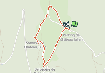
Trail Walking of 1.9 km to be discovered at Auvergne-Rhône-Alpes, Isère, Villard-de-Lans. This trail is proposed by LydiaMich .

Description

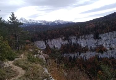
courte balade mais à voir.

Elevation profile

Positioning

Country:
France
Region :
Auvergne-Rhône-Alpes
Department/Province :
Isère
Municipality :
Villard-de-Lans
Location:
Unknown
Start:(UTM)
695850 ; 4991375 (31T) N.

Trails nearby

Trail Walking Châtelus - 38 bournillon porte du diable charmatte - Photo
Walking
GUIDE
randodyssée

Walking

Difficult
(1)
Châtelus, Auvergne-Rhône-Alpes, Isère, France
16.5 km | 34 km-effort
8h 7min
Yes
Trail Mountain bike Corrençon-en-Vercors - Grande Traversée des PréAlpes à VTT : Corrençon en Vercors - La Chapelle en Vercors - Photo
Mountain bike
tracegps

Mountain bike

Difficult
(1)
Corrençon-en-Vercors, Auvergne-Rhône-Alpes, Isère, France
25 km | 36 km-effort
3h 30min
No
Trail Walking Corrençon-en-Vercors - 38 tête chaudière  - Photo
Walking
GUIDE
randodyssée

Walking

Medium
Corrençon-en-Vercors, Auvergne-Rhône-Alpes, Isère, France
10.8 km | 22 km-effort
7h 3min
Yes
Trail Walking Rencurel - 38 vire bourne goule noire  - Photo
Walking
GUIDE
randodyssée

Walking

Medium
Rencurel, Auvergne-Rhône-Alpes, Isère, France
11.9 km | 24 km-effort
6h 44min
Yes
Trail Touring skiing Corrençon-en-Vercors - tête chaudière et petite moucherolle - Photo
Touring skiing
GUIDE
nadd73

Touring skiing

Easy
Corrençon-en-Vercors, Auvergne-Rhône-Alpes, Isère, France
11.9 km | 27 km-effort
5h 1min
Yes
Trail Walking Villard-de-Lans - crête de Ferrière et pas de Rages  - Photo
Walking
GUIDE
nadd73

Walking

Medium
Villard-de-Lans, Auvergne-Rhône-Alpes, Isère, France
13.5 km | 23 km-effort
6h 0min
Yes
Trail On foot Rencurel - La Balme Noire par la vire de Haute Valette - Photo
On foot
cmarit

On foot

Difficult
(1)
Rencurel, Auvergne-Rhône-Alpes, Isère, France
10.5 km | 21 km-effort
Unknown
Yes
Trail Walking Rencurel - 26 pas ferrière valchevriere - Photo
Walking
GUIDE
randodyssée

Walking

Medium
Rencurel, Auvergne-Rhône-Alpes, Isère, France
14.6 km | 24 km-effort
6h 1min
Yes
Trail Walking Châtelus - la grotte des Gaulois, le pas de l' Echarasson, porte du diable, pas de charmate - Photo
Walking
GUIDE
nadd73

Walking

Difficult
Châtelus, Auvergne-Rhône-Alpes, Isère, France
18.3 km | 37 km-effort
8h 23min
Yes


Close
My subscriptions