![](/images/other/stat-length.png)
![Trail Walking Saint-Mury-Monteymond - WE ANF à Saint-Mury : J2 - Col et Pointe de La Sitre en boucle. - Photo](https://media.geolcdn.com/t/1900/400/ext.pjpeg?maxdim=2&url=https%3A%2F%2Fstatic1.geolcdn.com%2Fsiteimages%2Fupload%2Ffiles%2F1553511878bg_sport_marche.png)
WE ANF à Saint-Mury : J2 - Col et Pointe de La Sitre en boucle.
Luc Saint-guillain
User
![Length](/images/other/stat-length.png)
Length
12.8 km
![Max alt](https://static1.geolcdn.com/siteimages/upload/files/1508320355ic_sort_altitude_max_24dp.png)
Max alt
2172 m
![Uphill gradient](https://static1.geolcdn.com/siteimages/upload/files/1508320355ic_sort_den_pos_24dp.png)
Uphill gradient
1065 m
![Km-Effort](/images/other/stat-length.png)
Km-Effort
27 km
![Min alt](https://static1.geolcdn.com/siteimages/upload/files/1508320355ic_sort_altitude_min_24dp.png)
Min alt
1156 m
![Downhill gradient](https://static1.geolcdn.com/siteimages/upload/files/1508320355ic_sort_den_neg_24dp.png)
Downhill gradient
1064 m
![Boucle](https://static1.geolcdn.com/siteimages/upload/files/16400158638029165_repeat_loop_refresh_sync_direction_icon.png)
Boucle
Yes
Creation date :
2024-07-17 10:20:19.87
Updated on :
2024-07-17 10:23:02.446
![Walking](https://static1.geolcdn.com/sitytour/trail-icons/101.png)
6h07
Difficulty : Difficult
![Scan this QR Code to open this trail in the SityTrail application](https://capi.geolives.com/qq0zvz2zws4bq2lad0pu/sitytour/trails/4124886/qr.png?size=200)
FREE GPS app for hiking
About
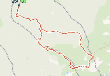
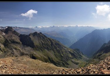
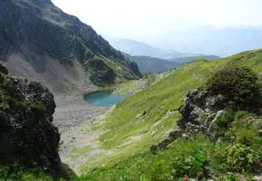
Trail Walking of 12.8 km to be discovered at Auvergne-Rhône-Alpes, Isère, Saint-Mury-Monteymond. This trail is proposed by Luc Saint-guillain.
Description
Départ du chalet Jean Castaing (col de Prélong).
Montée par ruisseau de La Vors.
Descente par refuge du pré du Mollard.
Positioning
Country:
France
Region :
Auvergne-Rhône-Alpes
Department/Province :
Isère
Municipality :
Saint-Mury-Monteymond
Location:
Unknown
Start:(Dec)
Start:(UTM)
729283 ; 5010053 (31T) N.
Comments
Trails nearby
![Trail On foot La Combe-de-Lancey - Chemin de Découverte (boucle Basse) - Photo](https://media.geolcdn.com/t/375/260/6915f95f-b034-4e84-88aa-9ed85af7f443.jpeg&format=jpg&maxdim=2)
![On foot On foot](https://static1.geolcdn.com/sitytour/trail-icons/100.png)
Chemin de Découverte (boucle Basse)
On foot
Easy
La Combe-de-Lancey,
Auvergne-Rhône-Alpes,
Isère,
France
![](/images/other/stat-length.png)
3.5 km | 5.1 km-effort
1h 9min
![](https://static1.geolcdn.com/siteimages/upload/files/16400158638029165_repeat_loop_refresh_sync_direction_icon.png)
Yes
![Trail On foot La Combe-de-Lancey - Chemin de Découverte (boucle Haute) - Photo](https://media.geolcdn.com/t/375/260/6a0cb0d1-93da-4068-99ad-9a549161cacf.jpeg&format=jpg&maxdim=2)
![On foot On foot](https://static1.geolcdn.com/sitytour/trail-icons/100.png)
Chemin de Découverte (boucle Haute)
On foot
Easy
La Combe-de-Lancey,
Auvergne-Rhône-Alpes,
Isère,
France
![](/images/other/stat-length.png)
3.5 km | 5.4 km-effort
1h 13min
![](https://static1.geolcdn.com/siteimages/upload/files/16400158638029165_repeat_loop_refresh_sync_direction_icon.png)
Yes
![Trail On foot Saint-Jean-le-Vieux - La Tour de Revel (par le Mollard) - Photo](https://media.geolcdn.com/t/375/260/9b2599de-7f79-405c-8210-bdfecfa7c849.jpeg&format=jpg&maxdim=2)
![On foot On foot](https://static1.geolcdn.com/sitytour/trail-icons/100.png)
La Tour de Revel (par le Mollard)
On foot
Easy
Saint-Jean-le-Vieux,
Auvergne-Rhône-Alpes,
Isère,
France
![](/images/other/stat-length.png)
7.9 km | 13.4 km-effort
3h 2min
![](https://static1.geolcdn.com/siteimages/upload/files/16400158638029165_repeat_loop_refresh_sync_direction_icon.png)
No
![Trail Walking La Combe-de-Lancey - Col du Pré du Molard - Photo](https://media.geolcdn.com/t/375/260/29dc783a-080e-448f-b06b-b4c5ed8fc906.jpg&format=jpg&maxdim=2)
![Walking Walking](https://static1.geolcdn.com/sitytour/trail-icons/101.png)
Col du Pré du Molard
Walking
Difficult
La Combe-de-Lancey,
Auvergne-Rhône-Alpes,
Isère,
France
![](/images/other/stat-length.png)
17.8 km | 33 km-effort
5h 19min
![](https://static1.geolcdn.com/siteimages/upload/files/16400158638029165_repeat_loop_refresh_sync_direction_icon.png)
Yes
![Trail Walking Saint-Mury-Monteymond - Lac Blanc au pied de Belledonne - Photo](https://media.geolcdn.com/t/375/260/be8bcf54-d056-4226-93e0-f27b8cc25845.jpg&format=jpg&maxdim=2)
![Walking Walking](https://static1.geolcdn.com/sitytour/trail-icons/101.png)
Lac Blanc au pied de Belledonne
Walking
Very difficult
Saint-Mury-Monteymond,
Auvergne-Rhône-Alpes,
Isère,
France
![](/images/other/stat-length.png)
12.2 km | 26 km-effort
5h 49min
![](https://static1.geolcdn.com/siteimages/upload/files/16400158638029165_repeat_loop_refresh_sync_direction_icon.png)
Yes
![Trail Walking Revel - Montagne 15/08/2023 - Photo](https://media.geolcdn.com/t/375/260/ca509cb3-3847-45e2-a337-c41964fdee08.jpg&format=jpg&maxdim=2)
![Walking Walking](https://static1.geolcdn.com/sitytour/trail-icons/101.png)
Montagne 15/08/2023
Walking
Difficult
Revel,
Auvergne-Rhône-Alpes,
Isère,
France
![](/images/other/stat-length.png)
16.2 km | 32 km-effort
6h 36min
![](https://static1.geolcdn.com/siteimages/upload/files/16400158638029165_repeat_loop_refresh_sync_direction_icon.png)
Yes
![Trail Walking Saint-Mury-Monteymond - Col et Pointe de la Sitre - Photo](https://media.geolcdn.com/t/375/260/12aa835d-a61b-4dc5-8899-8748a81192a8.jpg&format=jpg&maxdim=2)
![Walking Walking](https://static1.geolcdn.com/sitytour/trail-icons/101.png)
Col et Pointe de la Sitre
Walking
Very difficult
Saint-Mury-Monteymond,
Auvergne-Rhône-Alpes,
Isère,
France
![](/images/other/stat-length.png)
11.2 km | 23 km-effort
5h 14min
![](https://static1.geolcdn.com/siteimages/upload/files/16400158638029165_repeat_loop_refresh_sync_direction_icon.png)
Yes
![Trail Walking Revel - Grande Lauziere - Photo](https://media.geolcdn.com/t/375/260/6ecc9c2a-cff5-4a21-8446-c2fd0ace6af6.jpg&format=jpg&maxdim=2)
![Walking Walking](https://static1.geolcdn.com/sitytour/trail-icons/101.png)
Grande Lauziere
Walking
Difficult
Revel,
Auvergne-Rhône-Alpes,
Isère,
France
![](/images/other/stat-length.png)
22 km | 42 km-effort
8h 18min
![](https://static1.geolcdn.com/siteimages/upload/files/16400158638029165_repeat_loop_refresh_sync_direction_icon.png)
Yes
![Walking Walking](https://static1.geolcdn.com/sitytour/trail-icons/101.png)
Boucle , Lac du crozet depuis parking des 4 chemins
Walking
Very difficult
Revel,
Auvergne-Rhône-Alpes,
Isère,
France
![](/images/other/stat-length.png)
17.4 km | 33 km-effort
9h 10min
![](https://static1.geolcdn.com/siteimages/upload/files/16400158638029165_repeat_loop_refresh_sync_direction_icon.png)
Yes