


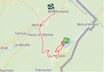

39 km | 49 km-effort

User


FREE GPS app for hiking
 SityTrail
IGN / Geographical institutes
SityTrail World
The world is yours!
Trail Walking of 27 km to be discovered at Bourgogne-Franche-Comté, Jura, Les Rousses. This trail is proposed by Mady Lambert.
Tout terrain, bois, très beaux points de vue, bonnes dénivellation. Bonnes chaussures indispensables.
 "
data-pinterest-text="Pin it"
data-tweet-text="share on twitter"
data-facebook-share-url="https://www.sitytrail.com/en/trails/4124112-les-rousses--lac-xles-roussesxx-fort-du-risouxx-belvedere-de-lavenna-/?photo=1#lg=1&slide=1"
data-twitter-share-url="https://www.sitytrail.com/en/trails/4124112-les-rousses--lac-xles-roussesxx-fort-du-risouxx-belvedere-de-lavenna-/?photo=1#lg=1&slide=1"
data-googleplus-share-url="https://www.sitytrail.com/en/trails/4124112-les-rousses--lac-xles-roussesxx-fort-du-risouxx-belvedere-de-lavenna-/?photo=1#lg=1&slide=1"
data-pinterest-share-url="https://www.sitytrail.com/en/trails/4124112-les-rousses--lac-xles-roussesxx-fort-du-risouxx-belvedere-de-lavenna-/?photo=1#lg=1&slide=1">
"
data-pinterest-text="Pin it"
data-tweet-text="share on twitter"
data-facebook-share-url="https://www.sitytrail.com/en/trails/4124112-les-rousses--lac-xles-roussesxx-fort-du-risouxx-belvedere-de-lavenna-/?photo=1#lg=1&slide=1"
data-twitter-share-url="https://www.sitytrail.com/en/trails/4124112-les-rousses--lac-xles-roussesxx-fort-du-risouxx-belvedere-de-lavenna-/?photo=1#lg=1&slide=1"
data-googleplus-share-url="https://www.sitytrail.com/en/trails/4124112-les-rousses--lac-xles-roussesxx-fort-du-risouxx-belvedere-de-lavenna-/?photo=1#lg=1&slide=1"
data-pinterest-share-url="https://www.sitytrail.com/en/trails/4124112-les-rousses--lac-xles-roussesxx-fort-du-risouxx-belvedere-de-lavenna-/?photo=1#lg=1&slide=1">
 "
data-pinterest-text="Pin it"
data-tweet-text="share on twitter"
data-facebook-share-url="https://www.sitytrail.com/en/trails/4124112-les-rousses--lac-xles-roussesxx-fort-du-risouxx-belvedere-de-lavenna-/?photo=2#lg=1&slide=2"
data-twitter-share-url="https://www.sitytrail.com/en/trails/4124112-les-rousses--lac-xles-roussesxx-fort-du-risouxx-belvedere-de-lavenna-/?photo=2#lg=1&slide=2"
data-googleplus-share-url="https://www.sitytrail.com/en/trails/4124112-les-rousses--lac-xles-roussesxx-fort-du-risouxx-belvedere-de-lavenna-/?photo=2#lg=1&slide=2"
data-pinterest-share-url="https://www.sitytrail.com/en/trails/4124112-les-rousses--lac-xles-roussesxx-fort-du-risouxx-belvedere-de-lavenna-/?photo=2#lg=1&slide=2">
"
data-pinterest-text="Pin it"
data-tweet-text="share on twitter"
data-facebook-share-url="https://www.sitytrail.com/en/trails/4124112-les-rousses--lac-xles-roussesxx-fort-du-risouxx-belvedere-de-lavenna-/?photo=2#lg=1&slide=2"
data-twitter-share-url="https://www.sitytrail.com/en/trails/4124112-les-rousses--lac-xles-roussesxx-fort-du-risouxx-belvedere-de-lavenna-/?photo=2#lg=1&slide=2"
data-googleplus-share-url="https://www.sitytrail.com/en/trails/4124112-les-rousses--lac-xles-roussesxx-fort-du-risouxx-belvedere-de-lavenna-/?photo=2#lg=1&slide=2"
data-pinterest-share-url="https://www.sitytrail.com/en/trails/4124112-les-rousses--lac-xles-roussesxx-fort-du-risouxx-belvedere-de-lavenna-/?photo=2#lg=1&slide=2">
 "
data-pinterest-text="Pin it"
data-tweet-text="share on twitter"
data-facebook-share-url="https://www.sitytrail.com/en/trails/4124112-les-rousses--lac-xles-roussesxx-fort-du-risouxx-belvedere-de-lavenna-/?photo=3#lg=1&slide=3"
data-twitter-share-url="https://www.sitytrail.com/en/trails/4124112-les-rousses--lac-xles-roussesxx-fort-du-risouxx-belvedere-de-lavenna-/?photo=3#lg=1&slide=3"
data-googleplus-share-url="https://www.sitytrail.com/en/trails/4124112-les-rousses--lac-xles-roussesxx-fort-du-risouxx-belvedere-de-lavenna-/?photo=3#lg=1&slide=3"
data-pinterest-share-url="https://www.sitytrail.com/en/trails/4124112-les-rousses--lac-xles-roussesxx-fort-du-risouxx-belvedere-de-lavenna-/?photo=3#lg=1&slide=3">
"
data-pinterest-text="Pin it"
data-tweet-text="share on twitter"
data-facebook-share-url="https://www.sitytrail.com/en/trails/4124112-les-rousses--lac-xles-roussesxx-fort-du-risouxx-belvedere-de-lavenna-/?photo=3#lg=1&slide=3"
data-twitter-share-url="https://www.sitytrail.com/en/trails/4124112-les-rousses--lac-xles-roussesxx-fort-du-risouxx-belvedere-de-lavenna-/?photo=3#lg=1&slide=3"
data-googleplus-share-url="https://www.sitytrail.com/en/trails/4124112-les-rousses--lac-xles-roussesxx-fort-du-risouxx-belvedere-de-lavenna-/?photo=3#lg=1&slide=3"
data-pinterest-share-url="https://www.sitytrail.com/en/trails/4124112-les-rousses--lac-xles-roussesxx-fort-du-risouxx-belvedere-de-lavenna-/?photo=3#lg=1&slide=3">
 "
data-pinterest-text="Pin it"
data-tweet-text="share on twitter"
data-facebook-share-url="https://www.sitytrail.com/en/trails/4124112-les-rousses--lac-xles-roussesxx-fort-du-risouxx-belvedere-de-lavenna-/?photo=4#lg=1&slide=4"
data-twitter-share-url="https://www.sitytrail.com/en/trails/4124112-les-rousses--lac-xles-roussesxx-fort-du-risouxx-belvedere-de-lavenna-/?photo=4#lg=1&slide=4"
data-googleplus-share-url="https://www.sitytrail.com/en/trails/4124112-les-rousses--lac-xles-roussesxx-fort-du-risouxx-belvedere-de-lavenna-/?photo=4#lg=1&slide=4"
data-pinterest-share-url="https://www.sitytrail.com/en/trails/4124112-les-rousses--lac-xles-roussesxx-fort-du-risouxx-belvedere-de-lavenna-/?photo=4#lg=1&slide=4">
"
data-pinterest-text="Pin it"
data-tweet-text="share on twitter"
data-facebook-share-url="https://www.sitytrail.com/en/trails/4124112-les-rousses--lac-xles-roussesxx-fort-du-risouxx-belvedere-de-lavenna-/?photo=4#lg=1&slide=4"
data-twitter-share-url="https://www.sitytrail.com/en/trails/4124112-les-rousses--lac-xles-roussesxx-fort-du-risouxx-belvedere-de-lavenna-/?photo=4#lg=1&slide=4"
data-googleplus-share-url="https://www.sitytrail.com/en/trails/4124112-les-rousses--lac-xles-roussesxx-fort-du-risouxx-belvedere-de-lavenna-/?photo=4#lg=1&slide=4"
data-pinterest-share-url="https://www.sitytrail.com/en/trails/4124112-les-rousses--lac-xles-roussesxx-fort-du-risouxx-belvedere-de-lavenna-/?photo=4#lg=1&slide=4">


Cycle

Walking

Walking

Walking

Walking

Walking

Walking

Walking
