


Dove

MartinBraudThierry
User
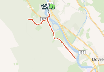

Length
5.4 km

Max alt
562 m

Uphill gradient
100 m
Km-Effort
6.8 km

Min alt
469 m

Downhill gradient
99 m
Boucle
Yes
Creation date :
2024-07-12 12:00:21.785
Updated on :
2024-07-13 12:32:07.513
1h42
Difficulty : Medium

FREE GPS app for hiking
 SityTrail
IGN / Geographical institutes
SityTrail World
The world is yours!
About
Trail Walking of 5.4 km to be discovered at Innlandet. This trail is proposed by MartinBraudThierry.
Positioning
Country:
Norway
Region :
Innlandet
Department/Province :
Unknown
Municipality :
Unknown
Location:
Unknown
Start:(Dec)
Start:(UTM)
511518 ; 6874149 (32V) N.
Comments
Trails nearby