![](/images/other/stat-length.png)
![Trail Walking Uvernet-Fours - Baume longe et col de cloche - Photo](https://media.geolcdn.com/t/1900/400/ext.pjpeg?maxdim=2&url=https%3A%2F%2Fstatic1.geolcdn.com%2Fsiteimages%2Fupload%2Ffiles%2F1553511878bg_sport_marche.png)
Baume longe et col de cloche
charollois
User
![Length](/images/other/stat-length.png)
Length
17.3 km
![Max alt](https://static1.geolcdn.com/siteimages/upload/files/1508320355ic_sort_altitude_max_24dp.png)
Max alt
2511 m
![Uphill gradient](https://static1.geolcdn.com/siteimages/upload/files/1508320355ic_sort_den_pos_24dp.png)
Uphill gradient
1680 m
![Km-Effort](/images/other/stat-length.png)
Km-Effort
41 km
![Min alt](https://static1.geolcdn.com/siteimages/upload/files/1508320355ic_sort_altitude_min_24dp.png)
Min alt
1126 m
![Downhill gradient](https://static1.geolcdn.com/siteimages/upload/files/1508320355ic_sort_den_neg_24dp.png)
Downhill gradient
2096 m
![Boucle](https://static1.geolcdn.com/siteimages/upload/files/16400158638029165_repeat_loop_refresh_sync_direction_icon.png)
Boucle
No
Creation date :
2024-07-12 08:22:12.0
Updated on :
2024-07-12 18:03:48.773
![Walking](https://static1.geolcdn.com/sitytour/trail-icons/101.png)
4h01
Difficulty : Medium
![Scan this QR Code to open this trail in the SityTrail application](https://capi.geolives.com/qq0zvz2zws4bq2lad0pu/sitytour/trails/4119836/qr.png?size=200)
FREE GPS app for hiking
About
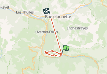
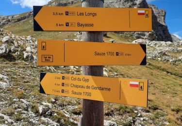
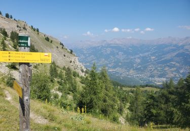
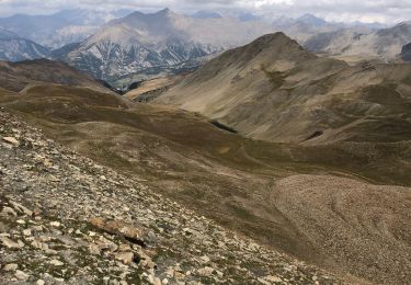
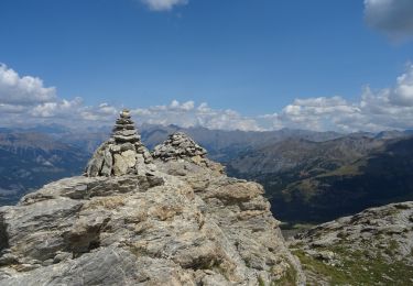
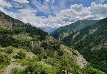
Trail Walking of 17.3 km to be discovered at Provence-Alpes-Côte d'Azur, Alpes-de-Haute-Provence, Uvernet-Fours. This trail is proposed by charollois.
Description
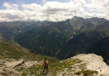
Très Agréable rando avec des pentes raides, des sentes en sous bois, des prairies fleuries, la vue sur le chapeau de gendarme.
Positioning
Country:
France
Region :
Provence-Alpes-Côte d'Azur
Department/Province :
Alpes-de-Haute-Provence
Municipality :
Uvernet-Fours
Location:
Unknown
Start:(Dec)
Start:(UTM)
313444 ; 4910362 (32T) N.
Comments
Trails nearby
![Trail Walking Uvernet-Fours - Col de la Cloche - Croix de Saint Médard Via Villard d'Abas - Photo](https://media.geolcdn.com/t/375/260/308bf2a1-9335-4e20-b2f5-d29a649f0d5e.jpg&format=jpg&maxdim=2)
![Walking Walking](https://static1.geolcdn.com/sitytour/trail-icons/101.png)
Col de la Cloche - Croix de Saint Médard Via Villard d'Abas
Walking
Very difficult
(1)
Uvernet-Fours,
Provence-Alpes-Côte d'Azur,
Alpes-de-Haute-Provence,
France
![](/images/other/stat-length.png)
10.5 km | 19.6 km-effort
4h 27min
![](https://static1.geolcdn.com/siteimages/upload/files/16400158638029165_repeat_loop_refresh_sync_direction_icon.png)
Yes
![Trail Walking Enchastrayes - chapeau de gendarme. Ubaye - Photo](https://media.geolcdn.com/t/375/260/ext.jpg?maxdim=2&url=https%3A%2F%2Fservices.sitytrail.com%2FGeolivesWS%2FDownloadMedia.ashx%3FTrailID%3D213716%26Media%3D20130816125107.jpg)
![Walking Walking](https://static1.geolcdn.com/sitytour/trail-icons/101.png)
chapeau de gendarme. Ubaye
Walking
Difficult
(1)
Enchastrayes,
Provence-Alpes-Côte d'Azur,
Alpes-de-Haute-Provence,
France
![](/images/other/stat-length.png)
16 km | 31 km-effort
7h 30min
![](https://static1.geolcdn.com/siteimages/upload/files/16400158638029165_repeat_loop_refresh_sync_direction_icon.png)
Yes
![Trail Walking Enchastrayes - chapeau de gendarme - Photo](https://media.geolcdn.com/t/375/260/33ebb070-0a87-4026-a47d-467969733ca3.jpg&format=jpg&maxdim=2)
![Walking Walking](https://static1.geolcdn.com/sitytour/trail-icons/101.png)
chapeau de gendarme
Walking
Medium
Enchastrayes,
Provence-Alpes-Côte d'Azur,
Alpes-de-Haute-Provence,
France
![](/images/other/stat-length.png)
13.5 km | 28 km-effort
6h 51min
![](https://static1.geolcdn.com/siteimages/upload/files/16400158638029165_repeat_loop_refresh_sync_direction_icon.png)
Yes
![Trail Walking Enchastrayes - col du Chapeau de gendarme et de Gyp Aller via flanc est Retour via flanc nord - Photo](https://media.geolcdn.com/t/375/260/eac4dd18-0f0f-4143-9343-f0bf7d4ed81b.jpg&format=jpg&maxdim=2)
![Walking Walking](https://static1.geolcdn.com/sitytour/trail-icons/101.png)
col du Chapeau de gendarme et de Gyp Aller via flanc est Retour via flanc nord
Walking
Difficult
Enchastrayes,
Provence-Alpes-Côte d'Azur,
Alpes-de-Haute-Provence,
France
![](/images/other/stat-length.png)
11.4 km | 25 km-effort
4h 29min
![](https://static1.geolcdn.com/siteimages/upload/files/16400158638029165_repeat_loop_refresh_sync_direction_icon.png)
Yes
![Trail Walking Uvernet-Fours - Ventebrun depuis Pont de Julien - Photo](https://media.geolcdn.com/t/375/260/851cfbca-49f7-4dce-84ca-2e56fcb5741d.jpg&format=jpg&maxdim=2)
![Walking Walking](https://static1.geolcdn.com/sitytour/trail-icons/101.png)
Ventebrun depuis Pont de Julien
Walking
Difficult
(1)
Uvernet-Fours,
Provence-Alpes-Côte d'Azur,
Alpes-de-Haute-Provence,
France
![](/images/other/stat-length.png)
15 km | 28 km-effort
6h 9min
![](https://static1.geolcdn.com/siteimages/upload/files/16400158638029165_repeat_loop_refresh_sync_direction_icon.png)
No
![Walking Walking](https://static1.geolcdn.com/sitytour/trail-icons/101.png)
Chapeaux du gendarme (20/08/2021)
Walking
Very difficult
Enchastrayes,
Provence-Alpes-Côte d'Azur,
Alpes-de-Haute-Provence,
France
![](/images/other/stat-length.png)
17.1 km | 33 km-effort
6h 24min
![](https://static1.geolcdn.com/siteimages/upload/files/16400158638029165_repeat_loop_refresh_sync_direction_icon.png)
Yes
![Trail Walking Uvernet-Fours - rando col de la cloche 8/07/2021 - Photo](https://media.geolcdn.com/t/375/260/95736b36-304b-4736-8102-5e823bc5f215.jpg&format=jpg&maxdim=2)
![Walking Walking](https://static1.geolcdn.com/sitytour/trail-icons/101.png)
rando col de la cloche 8/07/2021
Walking
Medium
Uvernet-Fours,
Provence-Alpes-Côte d'Azur,
Alpes-de-Haute-Provence,
France
![](/images/other/stat-length.png)
9.6 km | 18.8 km-effort
3h 48min
![](https://static1.geolcdn.com/siteimages/upload/files/16400158638029165_repeat_loop_refresh_sync_direction_icon.png)
Yes
![Snowshoes Snowshoes](https://static1.geolcdn.com/sitytour/trail-icons/504.png)
Pra Loup - Cabane Forestière du Fau
Snowshoes
Easy
Uvernet-Fours,
Provence-Alpes-Côte d'Azur,
Alpes-de-Haute-Provence,
France
![](/images/other/stat-length.png)
5.8 km | 8.6 km-effort
2h 20min
![](https://static1.geolcdn.com/siteimages/upload/files/16400158638029165_repeat_loop_refresh_sync_direction_icon.png)
Yes
![Trail Walking Uvernet-Fours - Uvernet-Fours - Boucle du Bachelard, sentier découverte - Photo](https://media.geolcdn.com/t/375/260/b183ca8e-1114-4c82-b909-fd0b8bb817bb.jpg&format=jpg&maxdim=2)
![Walking Walking](https://static1.geolcdn.com/sitytour/trail-icons/101.png)
Uvernet-Fours - Boucle du Bachelard, sentier découverte
Walking
Easy
(2)
Uvernet-Fours,
Provence-Alpes-Côte d'Azur,
Alpes-de-Haute-Provence,
France
![](/images/other/stat-length.png)
4.2 km | 5.2 km-effort
1h 4min
![](https://static1.geolcdn.com/siteimages/upload/files/16400158638029165_repeat_loop_refresh_sync_direction_icon.png)
Yes