Trail Walking Itteville - 2024-07-10 Rando Itteville - Photo

2024-07-10 Rando Itteville

© OpenStreetMap contributors
Length
Length
10.3 km
Max alt
Max alt
147 m
Uphill gradient
Uphill gradient
127 m
Km-Effort
Km-Effort  
12 km
Min alt
Min alt
52 m
Downhill gradient
Downhill gradient
128 m
Boucle
Boucle
Yes
Creation date :
2024-07-10 07:04:52.742
Updated on :
2024-07-10 17:44:59.299

(0 Reviews)

Walking
Walking
2h37
Difficulty : Easy

Scan this QR Code to open this trail in the SityTrail application

FREE GPS app for hiking

Logo SityTrail SityTrail

IGN / Geographical institutes

Download SityTrail from the App Store Download SityTrail from Google Play

Logo SityTrail SityTrail World

The world is yours!

Download SityTrail from the App Store Download SityTrail from Google Play Download SityTrail on Huawei AppGallery

About

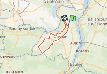
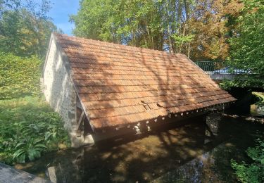
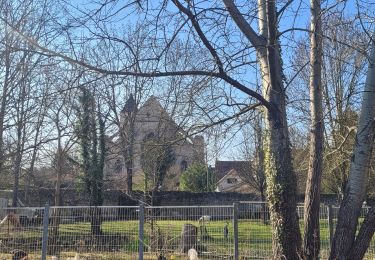
Trail Walking of 10.3 km to be discovered at Ile-de-France, Essonne, Itteville. This trail is proposed by jchezlemas.

Description

Rando de Martine et Alain Gauthier
Office de Tourisme de l'Arpajonnais
https://www.ot-coeuressonne.fr/

Elevation profile

Positioning

Country:
France
Region :
Ile-de-France
Department/Province :
Essonne
Municipality :
Itteville
Location:
Unknown
Start:(UTM)
452117 ; 5374691 (31U) N.

Trails nearby

Trail Walking Marolles-en-Hurepoix - Marolles Lardy Bouray St Vrain - Photo
Walking
philippebenne

Walking

Medium
(1)
Marolles-en-Hurepoix, Ile-de-France, Essonne, France
19.3 km | 23 km-effort
5h 10min
Yes
Trail Walking Itteville - Les vieilles ailes - Photo
Walking
c.chehere

Walking

Easy
(1)
Itteville, Ile-de-France, Essonne, France
16.8 km | 19.2 km-effort
3h 37min
Yes
Trail Mountain bike Lardy - Autour de Lardy en VTT - Photo
Mountain bike
tracegps

Mountain bike

Medium
(1)
Lardy, Ile-de-France, Essonne, France
31 km | 38 km-effort
2h 4min
Yes
Trail Walking Mennecy - Boucle 23 km au départ de Mennecy - Photo
Walking
GUIDE
chessyca

Walking

Very easy
Mennecy, Ile-de-France, Essonne, France
23 km | 26 km-effort
4h 52min
Yes
Trail Walking Ballancourt-sur-Essonne - Boucle autour de Ballancourt - Photo
Walking
GUIDE
chessyca

Walking

Medium
Ballancourt-sur-Essonne, Ile-de-France, Essonne, France
21 km | 25 km-effort
4h 47min
Yes
Trail Walking Baulne - De La Ferté Alais à Mennecy - Photo
Walking
GUIDE
chessyca

Walking

Very easy
Baulne, Ile-de-France, Essonne, France
20 km | 23 km-effort
4h 31min
No
Trail On foot Itteville - SityTrail - 3212203 - itteville - Photo
On foot
GUIDE
chessyca

On foot

Difficult
Itteville, Ile-de-France, Essonne, France
28 km | 33 km-effort
7h 32min
Yes
Trail On foot La Ferté-Alais - Boucle Orveau - Ferté Alais 27 km - Photo
On foot
GUIDE
chessyca

On foot

Difficult
La Ferté-Alais, Ile-de-France, Essonne, France
27 km | 33 km-effort
7h 26min
Yes
Trail On foot Itteville - Chemin des Marais - Photo
On foot
GUIDE+

On foot

Easy
Itteville, Ile-de-France, Essonne, France
14.3 km | 16 km-effort
3h 38min
No


Close
My subscriptions