![](/images/other/stat-length.png)
![Trail Walking Leucate - Leucate, boucle de la Gardiole - Photo](https://media.geolcdn.com/t/1900/400/ext.pjpeg?maxdim=2&url=https%3A%2F%2Fstatic1.geolcdn.com%2Fsiteimages%2Fupload%2Ffiles%2F1553511878bg_sport_marche.png)
Leucate, boucle de la Gardiole
Santblasi
User
![Length](/images/other/stat-length.png)
![Max alt](https://static1.geolcdn.com/siteimages/upload/files/1508320355ic_sort_altitude_max_24dp.png)
![Uphill gradient](https://static1.geolcdn.com/siteimages/upload/files/1508320355ic_sort_den_pos_24dp.png)
![Km-Effort](/images/other/stat-length.png)
![Min alt](https://static1.geolcdn.com/siteimages/upload/files/1508320355ic_sort_altitude_min_24dp.png)
![Downhill gradient](https://static1.geolcdn.com/siteimages/upload/files/1508320355ic_sort_den_neg_24dp.png)
![Boucle](https://static1.geolcdn.com/siteimages/upload/files/16400158638029165_repeat_loop_refresh_sync_direction_icon.png)
![Walking](https://static1.geolcdn.com/sitytour/trail-icons/101.png)
4h16
Difficulty : Medium
![Scan this QR Code to open this trail in the SityTrail application](https://capi.geolives.com/qq0zvz2zws4bq2lad0pu/sitytour/trails/4116866/qr.png?size=200)
FREE GPS app for hiking
About
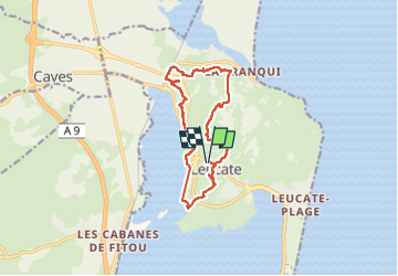
Trail Walking of 13.6 km to be discovered at Occitania, Aude, Leucate. This trail is proposed by Santblasi.
Description
Départ parking O. Tourisme de Leucate village.
Suivre sentier vignerons puis surveiller tracé et suivre petites routes, chemins carrossables et pistes entre vignes, murets et pinèdes sur plateau calcaire.
Après avoir admiré La Franquie, partir à gauche en direction des étangs. Descendre jusqu'à la piste cyclable et repartir dans les pinèdes.
On termine le long de l'étang avant de grimper et passer visiter le château.
Descente au village et arrivée au parking.
enregistrement resté fermé en bord d'étang sans incidence sur les dénivelés.
2 allé
Positioning
Comments
Trails nearby
![Trail Walking Leucate - mon sentier des pêcheurs - Photo](https://media.geolcdn.com/t/375/260/d041d0df-07da-4421-a9ea-d982392d3e0c.jpg&format=jpg&maxdim=2)
![Walking Walking](https://static1.geolcdn.com/sitytour/trail-icons/101.png)
Walking
![](/images/other/stat-length.png)
![](https://static1.geolcdn.com/siteimages/upload/files/16400158638029165_repeat_loop_refresh_sync_direction_icon.png)
![Trail Walking Leucate - Leucate village - Photo](https://media.geolcdn.com/t/375/260/ext.jpg?maxdim=2&url=https%3A%2F%2Fservices.sitytrail.com%2FGeolivesWS%2FDownloadMedia.ashx%3FTrailID%3D179085%26Media%3Df1524f36-0682-4bf6-975a-882cd23421f5.JPG)
![Walking Walking](https://static1.geolcdn.com/sitytour/trail-icons/101.png)
Walking
![](/images/other/stat-length.png)
![](https://static1.geolcdn.com/siteimages/upload/files/16400158638029165_repeat_loop_refresh_sync_direction_icon.png)
![Trail Mountain bike Leucate - Leucate sur un plateau ! - Photo](https://media.geolcdn.com/t/375/260/ext.jpg?maxdim=2&url=https%3A%2F%2Fservices.sitytrail.com%2FGeolivesWS%2FDownloadMedia.ashx%3FTrailID%3D100672%26Media%3D196_3.jpg)
![Mountain bike Mountain bike](https://static1.geolcdn.com/sitytour/trail-icons/202.png)
Mountain bike
![](/images/other/stat-length.png)
![](https://static1.geolcdn.com/siteimages/upload/files/16400158638029165_repeat_loop_refresh_sync_direction_icon.png)
![Trail Mountain bike Leucate - VTT Leucate La Palme - Photo](https://media.geolcdn.com/t/375/260/f6afc4d0-f8dc-4d8d-bdc2-3236cac7bfec.jpg&format=jpg&maxdim=2)
![Mountain bike Mountain bike](https://static1.geolcdn.com/sitytour/trail-icons/202.png)
Mountain bike
![](/images/other/stat-length.png)
![](https://static1.geolcdn.com/siteimages/upload/files/16400158638029165_repeat_loop_refresh_sync_direction_icon.png)
![Trail Walking Leucate - Leucate Sentier du guetteur+ château - Photo](https://media.geolcdn.com/t/375/260/0d9f9422-d3ba-4f9e-b0b9-30df507d067c.jpg&format=jpg&maxdim=2)
![Walking Walking](https://static1.geolcdn.com/sitytour/trail-icons/101.png)
Walking
![](/images/other/stat-length.png)
![](https://static1.geolcdn.com/siteimages/upload/files/16400158638029165_repeat_loop_refresh_sync_direction_icon.png)
![Trail Walking Leucate - plateau leucate - sud est - Photo](https://media.geolcdn.com/t/375/260/fc551c80-a7a1-459f-83d9-ef8bc94cafd9.jpg&format=jpg&maxdim=2)
![Walking Walking](https://static1.geolcdn.com/sitytour/trail-icons/101.png)
Walking
![](/images/other/stat-length.png)
![](https://static1.geolcdn.com/siteimages/upload/files/16400158638029165_repeat_loop_refresh_sync_direction_icon.png)
![Trail Walking Leucate - leucate - cap des frères (sentier des bergers) -la franqui (sentier des guetteurs) - leucate (se tier des vignerons) - Photo](https://media.geolcdn.com/t/375/260/5389bc4c-6ebc-475a-8eed-23be4124a740.jpg&format=jpg&maxdim=2)
![Walking Walking](https://static1.geolcdn.com/sitytour/trail-icons/101.png)
Walking
![](/images/other/stat-length.png)
![](https://static1.geolcdn.com/siteimages/upload/files/16400158638029165_repeat_loop_refresh_sync_direction_icon.png)
![Trail Walking Leucate - 2023-02-03_17h08m34_SityTrail - 3539502 - leucate-plateau-chemin-vigneronx-franquix-le-fort-xcao-frerex-semaphore - Photo](https://media.geolcdn.com/t/375/260/ext.jpg?maxdim=2&url=https%3A%2F%2Fstatic1.geolcdn.com%2Fsiteimages%2Fupload%2Ffiles%2F1553511878bg_sport_marche.png)
![Walking Walking](https://static1.geolcdn.com/sitytour/trail-icons/101.png)
Walking
![](/images/other/stat-length.png)
![](https://static1.geolcdn.com/siteimages/upload/files/16400158638029165_repeat_loop_refresh_sync_direction_icon.png)
![Trail Walking Leucate - Leucate château falaise - Photo](https://media.geolcdn.com/t/375/260/3cce4778-81ed-4254-af5e-b0b5f1ccbabf.jpg&format=jpg&maxdim=2)
![Walking Walking](https://static1.geolcdn.com/sitytour/trail-icons/101.png)
Walking
![](/images/other/stat-length.png)
![](https://static1.geolcdn.com/siteimages/upload/files/16400158638029165_repeat_loop_refresh_sync_direction_icon.png)