![](/images/other/stat-length.png)
![Trail Hybrid bike Yerres - chemin des Roses Reau Sénart - Photo](https://media.geolcdn.com/t/1900/400/f8ba0ac5-2833-4c96-a60f-1699fbd5bc2d.jpg&format=pjpeg&maxdim=2)
chemin des Roses Reau Sénart
Catherine de Brunoy
User
![Length](/images/other/stat-length.png)
Length
62 km
![Max alt](https://static1.geolcdn.com/siteimages/upload/files/1508320355ic_sort_altitude_max_24dp.png)
Max alt
102 m
![Uphill gradient](https://static1.geolcdn.com/siteimages/upload/files/1508320355ic_sort_den_pos_24dp.png)
Uphill gradient
433 m
![Km-Effort](/images/other/stat-length.png)
Km-Effort
67 km
![Min alt](https://static1.geolcdn.com/siteimages/upload/files/1508320355ic_sort_altitude_min_24dp.png)
Min alt
37 m
![Downhill gradient](https://static1.geolcdn.com/siteimages/upload/files/1508320355ic_sort_den_neg_24dp.png)
Downhill gradient
406 m
![Boucle](https://static1.geolcdn.com/siteimages/upload/files/16400158638029165_repeat_loop_refresh_sync_direction_icon.png)
Boucle
No
Creation date :
2024-07-09 06:58:30.467
Updated on :
2024-07-09 13:43:15.524
![Hybrid bike](https://static1.geolcdn.com/sitytour/trail-icons/203.png)
4h08
Difficulty : Very difficult
![Scan this QR Code to open this trail in the SityTrail application](https://capi.geolives.com/qq0zvz2zws4bq2lad0pu/sitytour/trails/4116648/qr.png?size=200)
FREE GPS app for hiking
About
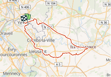
Trail Hybrid bike of 62 km to be discovered at Ile-de-France, Essonne, Yerres. This trail is proposed by Catherine de Brunoy.
Description
Villecresnes coulée verte chemin des Roses Yebles Reau picnic école retour étangs Lieusaint Tigery Forêt Sénart petit chemin. Christian Pontier
Positioning
Country:
France
Region :
Ile-de-France
Department/Province :
Essonne
Municipality :
Yerres
Location:
Unknown
Start:(Dec)
Start:(UTM)
462320 ; 5395718 (31U) N.
Comments
Trails nearby
![Trail On foot Villecresnes - L 20 boucle golf villecresnes et ancienne voie de chemin de fer - Photo](https://media.geolcdn.com/t/375/260/ext.jpg?maxdim=2&url=https%3A%2F%2Fstatic1.geolcdn.com%2Fsiteimages%2Fupload%2Ffiles%2F1545311037marcheuse_200dpi.jpg)
![On foot On foot](https://static1.geolcdn.com/sitytour/trail-icons/100.png)
L 20 boucle golf villecresnes et ancienne voie de chemin de fer
On foot
Very easy
(6)
Villecresnes,
Ile-de-France,
Val-de-Marne,
France
![](/images/other/stat-length.png)
6.5 km | 7.7 km-effort
1h 44min
![](https://static1.geolcdn.com/siteimages/upload/files/16400158638029165_repeat_loop_refresh_sync_direction_icon.png)
Yes
![Trail Walking Boussy-Saint-Antoine - GRP CV-IDF 04 - Photo](https://media.geolcdn.com/t/375/260/9a88b6b6-acb4-4798-9224-ae0478acaf21.jpg&format=jpg&maxdim=2)
![Walking Walking](https://static1.geolcdn.com/sitytour/trail-icons/101.png)
GRP CV-IDF 04
Walking
Difficult
(1)
Boussy-Saint-Antoine,
Ile-de-France,
Essonne,
France
![](/images/other/stat-length.png)
16.8 km | 18.6 km-effort
4h 13min
![](https://static1.geolcdn.com/siteimages/upload/files/16400158638029165_repeat_loop_refresh_sync_direction_icon.png)
No
![Trail Walking Mandres-les-Roses - J 26 Mandres, Boussy , Brunoy le chemin des fresques - Photo](https://media.geolcdn.com/t/375/260/a7099e05-5a69-431c-83ab-49f9701f5dd5.jpg&format=jpg&maxdim=2)
![Walking Walking](https://static1.geolcdn.com/sitytour/trail-icons/101.png)
J 26 Mandres, Boussy , Brunoy le chemin des fresques
Walking
Medium
(2)
Mandres-les-Roses,
Ile-de-France,
Val-de-Marne,
France
![](/images/other/stat-length.png)
12.2 km | 13.8 km-effort
3h 7min
![](https://static1.geolcdn.com/siteimages/upload/files/16400158638029165_repeat_loop_refresh_sync_direction_icon.png)
Yes
![Trail Walking Yerres - BM Foret Regionale de Grobois 10km - Photo](https://media.geolcdn.com/t/375/260/ext.jpg?maxdim=2&url=https%3A%2F%2Fstatic1.geolcdn.com%2Fsiteimages%2Fupload%2Ffiles%2F1553511878bg_sport_marche.png)
![Walking Walking](https://static1.geolcdn.com/sitytour/trail-icons/101.png)
BM Foret Regionale de Grobois 10km
Walking
Medium
(1)
Yerres,
Ile-de-France,
Essonne,
France
![](/images/other/stat-length.png)
10.4 km | 11 km-effort
2h 30min
![](https://static1.geolcdn.com/siteimages/upload/files/16400158638029165_repeat_loop_refresh_sync_direction_icon.png)
Yes
![Trail Walking Yerres - BM Foret Regionale Grosbois 10km - Photo](https://media.geolcdn.com/t/375/260/ext.jpg?maxdim=2&url=https%3A%2F%2Fstatic1.geolcdn.com%2Fsiteimages%2Fupload%2Ffiles%2F1553511878bg_sport_marche.png)
![Walking Walking](https://static1.geolcdn.com/sitytour/trail-icons/101.png)
BM Foret Regionale Grosbois 10km
Walking
Medium
(1)
Yerres,
Ile-de-France,
Essonne,
France
![](/images/other/stat-length.png)
9.8 km | 10.5 km-effort
2h 23min
![](https://static1.geolcdn.com/siteimages/upload/files/16400158638029165_repeat_loop_refresh_sync_direction_icon.png)
Yes
![Trail On foot Brunoy - L 39 Brunoy, les bords de l'Yerres - Photo](https://media.geolcdn.com/t/375/260/ebb13649-b3e9-4bd9-9011-035537427274.jpg&format=jpg&maxdim=2)
![On foot On foot](https://static1.geolcdn.com/sitytour/trail-icons/100.png)
L 39 Brunoy, les bords de l'Yerres
On foot
Very easy
(4)
Brunoy,
Ile-de-France,
Essonne,
France
![](/images/other/stat-length.png)
5.4 km | 6.1 km-effort
1h 49min
![](https://static1.geolcdn.com/siteimages/upload/files/16400158638029165_repeat_loop_refresh_sync_direction_icon.png)
Yes
![Trail Walking Montgeron - J 38 Montgeron la Pelouse, forêt de Sénart - Photo](https://media.geolcdn.com/t/375/260/f009853b-b232-40f1-8161-c380b5b5f65c.jpg&format=jpg&maxdim=2)
![Walking Walking](https://static1.geolcdn.com/sitytour/trail-icons/101.png)
J 38 Montgeron la Pelouse, forêt de Sénart
Walking
Difficult
(3)
Montgeron,
Ile-de-France,
Essonne,
France
![](/images/other/stat-length.png)
12.4 km | 13.3 km-effort
3h 1min
![](https://static1.geolcdn.com/siteimages/upload/files/16400158638029165_repeat_loop_refresh_sync_direction_icon.png)
Yes
![Trail On foot Boussy-Saint-Antoine - L 32: Boussy St Antoine l'Yerres et le Gord - Photo](https://media.geolcdn.com/t/375/260/0167f6d8-7862-4a56-9e45-6680bff9395f.jpg&format=jpg&maxdim=2)
![On foot On foot](https://static1.geolcdn.com/sitytour/trail-icons/100.png)
L 32: Boussy St Antoine l'Yerres et le Gord
On foot
Very easy
(3)
Boussy-Saint-Antoine,
Ile-de-France,
Essonne,
France
![](/images/other/stat-length.png)
6.2 km | 7.2 km-effort
1h 38min
![](https://static1.geolcdn.com/siteimages/upload/files/16400158638029165_repeat_loop_refresh_sync_direction_icon.png)
Yes
![Trail Walking Yerres - J 43 Yerres Parc Caillebotte, île des Prévôts - Photo](https://media.geolcdn.com/t/375/260/3326873b-9942-4059-9e6b-fa272d49fbc4.jpg&format=jpg&maxdim=2)
![Walking Walking](https://static1.geolcdn.com/sitytour/trail-icons/101.png)
J 43 Yerres Parc Caillebotte, île des Prévôts
Walking
Medium
(4)
Yerres,
Ile-de-France,
Essonne,
France
![](/images/other/stat-length.png)
11.4 km | 13.1 km-effort
2h 59min
![](https://static1.geolcdn.com/siteimages/upload/files/16400158638029165_repeat_loop_refresh_sync_direction_icon.png)
Yes