Trail Road bike Varces-Allières-et-Risset - Gresse en Vercors - col de l'Arzelier - Photo

Gresse en Vercors - col de l'Arzelier

© OpenStreetMap contributors
Length
Length
88 km
Max alt
Max alt
1249 m
Uphill gradient
Uphill gradient
1912 m
Km-Effort
Km-Effort  
113 km
Min alt
Min alt
264 m
Downhill gradient
Downhill gradient
1730 m
Boucle
Boucle
No
Creation date :
2024-07-09 06:25:32.965
Updated on :
2024-07-09 12:14:09.139

(0 Reviews)

Road bike
Road bike
5h06
Difficulty : Difficult

Scan this QR Code to open this trail in the SityTrail application

FREE GPS app for hiking

Logo SityTrail SityTrail

IGN / Geographical institutes

Download SityTrail from the App Store Download SityTrail from Google Play

Logo SityTrail SityTrail World

The world is yours!

Download SityTrail from the App Store Download SityTrail from Google Play Download SityTrail on Huawei AppGallery

About

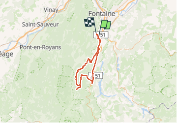
Trail Road bike of 88 km to be discovered at Auvergne-Rhône-Alpes, Isère, Varces-Allières-et-Risset. This trail is proposed by Jean-Marie Bousquet.

Description

boucle au départ des hauts de Claix via Monestier de Clermont, Gresse en Vercors et retour par le col de l'Arzelier

Elevation profile

Positioning

Country:
France
Region :
Auvergne-Rhône-Alpes
Department/Province :
Isère
Municipality :
Varces-Allières-et-Risset
Location:
Unknown
Start:(UTM)
710156 ; 4998167 (31T) N.

Trails nearby

Trail Snowshoes Lans-en-Vercors - La Crête des Ramées de nuit en raquettes - Photo
Snowshoes
patjobou

Snowshoes

Medium
(1)
Lans-en-Vercors, Auvergne-Rhône-Alpes, Isère, France
8 km | 13.4 km-effort
4h 9min
Yes
Trail Walking Lans-en-Vercors - Le Pic saint michel - Photo
Walking
patjobou

Walking

Easy
(1)
Lans-en-Vercors, Auvergne-Rhône-Alpes, Isère, France
6.5 km | 13.2 km-effort
2h 38min
No
Trail Walking Lans-en-Vercors - le vertige des cimes - Photo
Walking
jeanfcd

Walking

Medium
(1)
Lans-en-Vercors, Auvergne-Rhône-Alpes, Isère, France
6.3 km | 11 km-effort
2h 9min
Yes
Trail Walking Claix - caba - Photo
Walking
Sylvie Mathiot

Walking

Very easy
(1)
Claix, Auvergne-Rhône-Alpes, Isère, France
8.7 km | 16.6 km-effort
5h 2min
Yes
Trail Walking Claix - Le balcon du pic Saint Michel Par la grotte des pouliches - Photo
Walking
GUIDE
nadd73

Walking

Difficult
Claix, Auvergne-Rhône-Alpes, Isère, France
14.5 km | 31 km-effort
8h 0min
Yes
Trail Nordic walking Claix - Le Peuil 5 Km - Photo
Nordic walking
patjobou

Nordic walking

Easy
(1)
Claix, Auvergne-Rhône-Alpes, Isère, France
5.3 km | 7.1 km-effort
1h 28min
Yes
Trail Walking Lans-en-Vercors - Belvédère de Lans (Passerelle) Eté - Photo
Walking
patjobou

Walking

Easy
(1)
Lans-en-Vercors, Auvergne-Rhône-Alpes, Isère, France
5.8 km | 10.3 km-effort
1h 20min
Yes
Trail Walking Champ-sur-Drac - 38 Couvent St Michel Champ / drac - Photo
Walking
ericf64

Walking

Medium
Champ-sur-Drac, Auvergne-Rhône-Alpes, Isère, France
9.4 km | 19.7 km-effort
3h 0min
Yes
Trail Walking Seyssins - moucheroutte  - Photo
Walking
Youcef Atallah

Walking

Very difficult
Seyssins, Auvergne-Rhône-Alpes, Isère, France
25 km | 43 km-effort
5h 0min
No


Close
My subscriptions