![](/images/other/stat-length.png)
![Trail Walking Fontanès - Fontanès - Photo](https://media.geolcdn.com/t/1900/400/ext.pjpeg?maxdim=2&url=https%3A%2F%2Fstatic1.geolcdn.com%2Fsiteimages%2Fupload%2Ffiles%2F1553511878bg_sport_marche.png)
Fontanès
yvon42
User
![Length](/images/other/stat-length.png)
Length
10.6 km
![Max alt](https://static1.geolcdn.com/siteimages/upload/files/1508320355ic_sort_altitude_max_24dp.png)
Max alt
873 m
![Uphill gradient](https://static1.geolcdn.com/siteimages/upload/files/1508320355ic_sort_den_pos_24dp.png)
Uphill gradient
286 m
![Km-Effort](/images/other/stat-length.png)
Km-Effort
14.4 km
![Min alt](https://static1.geolcdn.com/siteimages/upload/files/1508320355ic_sort_altitude_min_24dp.png)
Min alt
691 m
![Downhill gradient](https://static1.geolcdn.com/siteimages/upload/files/1508320355ic_sort_den_neg_24dp.png)
Downhill gradient
285 m
![Boucle](https://static1.geolcdn.com/siteimages/upload/files/16400158638029165_repeat_loop_refresh_sync_direction_icon.png)
Boucle
Yes
Creation date :
2024-07-07 08:33:57.983
Updated on :
2024-07-07 13:47:38.98
![Walking](https://static1.geolcdn.com/sitytour/trail-icons/101.png)
4h35
Difficulty : Easy
![Scan this QR Code to open this trail in the SityTrail application](https://capi.geolives.com/qq0zvz2zws4bq2lad0pu/sitytour/trails/4114585/qr.png?size=200)
FREE GPS app for hiking
About
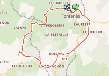
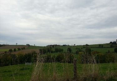
Trail Walking of 10.6 km to be discovered at Auvergne-Rhône-Alpes, Loire, Fontanès. This trail is proposed by yvon42.
Description
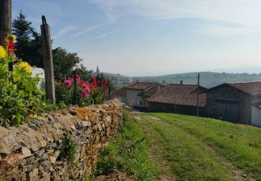
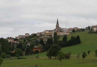
jolie randonnée à travers la campagne et dans les bois. Léger dénivelé et possibilité de s'arrêter pour le pique-nique vers les antennes de St Héand.
Positioning
Country:
France
Region :
Auvergne-Rhône-Alpes
Department/Province :
Loire
Municipality :
Fontanès
Location:
Unknown
Start:(Dec)
Start:(UTM)
612234 ; 5044851 (31T) N.
Comments
Trails nearby
![Trail Walking Saint-Christo-en-Jarez - st chisto en jarez - Photo](https://media.geolcdn.com/t/375/260/ext.jpg?maxdim=2&url=https%3A%2F%2Fservices.sitytrail.com%2FGeolivesWS%2FDownloadMedia.ashx%3FTrailID%3D476353%26Media%3Dfix__20150927104514.jpg)
![Walking Walking](https://static1.geolcdn.com/sitytour/trail-icons/101.png)
st chisto en jarez
Walking
Easy
Saint-Christo-en-Jarez,
Auvergne-Rhône-Alpes,
Loire,
France
![](/images/other/stat-length.png)
10.4 km | 14.5 km-effort
2h 14min
![](https://static1.geolcdn.com/siteimages/upload/files/16400158638029165_repeat_loop_refresh_sync_direction_icon.png)
Yes
![Trail Walking Saint-Héand - St Heand, Montrond, Mont Morin, Pierre de la Bauche et retour St Heand - Photo](https://media.geolcdn.com/t/375/260/ext.jpg?maxdim=2&url=https%3A%2F%2Fstatic1.geolcdn.com%2Fsiteimages%2Fupload%2Ffiles%2F1553511878bg_sport_marche.png)
![Walking Walking](https://static1.geolcdn.com/sitytour/trail-icons/101.png)
St Heand, Montrond, Mont Morin, Pierre de la Bauche et retour St Heand
Walking
Medium
(1)
Saint-Héand,
Auvergne-Rhône-Alpes,
Loire,
France
![](/images/other/stat-length.png)
16 km | 23 km-effort
5h 20min
![](https://static1.geolcdn.com/siteimages/upload/files/16400158638029165_repeat_loop_refresh_sync_direction_icon.png)
Yes
![Trail Walking Valfleury - Valfleury - Découverte de ce petit Lourdes et de ses environs - Photo](https://media.geolcdn.com/t/375/260/16f0dea3-73b6-45fe-b6f5-0da3d54ae22a.jpg&format=jpg&maxdim=2)
![Walking Walking](https://static1.geolcdn.com/sitytour/trail-icons/101.png)
Valfleury - Découverte de ce petit Lourdes et de ses environs
Walking
Medium
Valfleury,
Auvergne-Rhône-Alpes,
Loire,
France
![](/images/other/stat-length.png)
6.4 km | 9.5 km-effort
1h 54min
![](https://static1.geolcdn.com/siteimages/upload/files/16400158638029165_repeat_loop_refresh_sync_direction_icon.png)
Yes
![Trail On foot Saint-Christo-en-Jarez - Le sentier nature du Paradis - Photo](https://media.geolcdn.com/t/375/260/5a37cab4-edc0-4c60-8763-35c1aae808b3.jpeg&format=jpg&maxdim=2)
![On foot On foot](https://static1.geolcdn.com/sitytour/trail-icons/100.png)
Le sentier nature du Paradis
On foot
Easy
Saint-Christo-en-Jarez,
Auvergne-Rhône-Alpes,
Loire,
France
![](/images/other/stat-length.png)
7.8 km | 11.3 km-effort
2h 34min
![](https://static1.geolcdn.com/siteimages/upload/files/16400158638029165_repeat_loop_refresh_sync_direction_icon.png)
Yes
![Trail Walking Marcenod - Marcenod - Photo](https://media.geolcdn.com/t/375/260/e494fe96-10db-4327-a5b0-85a327faee11.jpg&format=jpg&maxdim=2)
![Walking Walking](https://static1.geolcdn.com/sitytour/trail-icons/101.png)
Marcenod
Walking
Very easy
Marcenod,
Auvergne-Rhône-Alpes,
Loire,
France
![](/images/other/stat-length.png)
20 km | 29 km-effort
4h 50min
![](https://static1.geolcdn.com/siteimages/upload/files/16400158638029165_repeat_loop_refresh_sync_direction_icon.png)
Yes
![Trail Walking Sorbiers - sorbiers 23/2 - Photo](https://media.geolcdn.com/t/375/260/ext.jpg?maxdim=2&url=https%3A%2F%2Fstatic1.geolcdn.com%2Fsiteimages%2Fupload%2Ffiles%2F1553511878bg_sport_marche.png)
![Walking Walking](https://static1.geolcdn.com/sitytour/trail-icons/101.png)
sorbiers 23/2
Walking
Difficult
(1)
Sorbiers,
Auvergne-Rhône-Alpes,
Loire,
France
![](/images/other/stat-length.png)
23 km | 35 km-effort
4h 36min
![](https://static1.geolcdn.com/siteimages/upload/files/16400158638029165_repeat_loop_refresh_sync_direction_icon.png)
Yes
![Trail Walking Sorbiers - sorbiers - Photo](https://media.geolcdn.com/t/375/260/ext.jpg?maxdim=2&url=https%3A%2F%2Fstatic1.geolcdn.com%2Fsiteimages%2Fupload%2Ffiles%2F1553511878bg_sport_marche.png)
![Walking Walking](https://static1.geolcdn.com/sitytour/trail-icons/101.png)
sorbiers
Walking
Difficult
(1)
Sorbiers,
Auvergne-Rhône-Alpes,
Loire,
France
![](/images/other/stat-length.png)
23 km | 36 km-effort
4h 46min
![](https://static1.geolcdn.com/siteimages/upload/files/16400158638029165_repeat_loop_refresh_sync_direction_icon.png)
Yes
![Trail Walking Sorbiers - sorbiers-st christo - valfeury - Photo](https://media.geolcdn.com/t/375/260/ext.jpg?maxdim=2&url=https%3A%2F%2Fstatic1.geolcdn.com%2Fsiteimages%2Fupload%2Ffiles%2F1553511878bg_sport_marche.png)
![Walking Walking](https://static1.geolcdn.com/sitytour/trail-icons/101.png)
sorbiers-st christo - valfeury
Walking
Medium
(1)
Sorbiers,
Auvergne-Rhône-Alpes,
Loire,
France
![](/images/other/stat-length.png)
23 km | 35 km-effort
4h 32min
![](https://static1.geolcdn.com/siteimages/upload/files/16400158638029165_repeat_loop_refresh_sync_direction_icon.png)
Yes
![Trail Walking Saint-Héand - izzy - Photo](https://media.geolcdn.com/t/375/260/ext.jpg?maxdim=2&url=https%3A%2F%2Fservices.sitytrail.com%2FGeolivesWS%2FDownloadMedia.ashx%3FTrailID%3D230294%26Media%3Dfix__20131101155052.jpg)
![Walking Walking](https://static1.geolcdn.com/sitytour/trail-icons/101.png)
izzy
Walking
Easy
Saint-Héand,
Auvergne-Rhône-Alpes,
Loire,
France
![](/images/other/stat-length.png)
5.9 km | 8.1 km-effort
1h 10min
![](https://static1.geolcdn.com/siteimages/upload/files/16400158638029165_repeat_loop_refresh_sync_direction_icon.png)
Yes