![](/images/other/stat-length.png)
![Trail Walking La Léchère - Col des Génisses par le refuge du Nant du Beurre - Photo](https://media.geolcdn.com/t/1900/400/ext.pjpeg?maxdim=2&url=https%3A%2F%2Fmedia.geolcdn.com%2Ff%2Fc621086d-e802-4fc9-b77f-57f582faf42d.jpg)
Col des Génisses par le refuge du Nant du Beurre
GuyVachet
User
![Length](/images/other/stat-length.png)
![Max alt](https://static1.geolcdn.com/siteimages/upload/files/1508320355ic_sort_altitude_max_24dp.png)
![Uphill gradient](https://static1.geolcdn.com/siteimages/upload/files/1508320355ic_sort_den_pos_24dp.png)
![Km-Effort](/images/other/stat-length.png)
![Min alt](https://static1.geolcdn.com/siteimages/upload/files/1508320355ic_sort_altitude_min_24dp.png)
![Downhill gradient](https://static1.geolcdn.com/siteimages/upload/files/1508320355ic_sort_den_neg_24dp.png)
![Boucle](https://static1.geolcdn.com/siteimages/upload/files/16400158638029165_repeat_loop_refresh_sync_direction_icon.png)
![Walking](https://static1.geolcdn.com/sitytour/trail-icons/101.png)
6h20
Difficulty : Very difficult
![Scan this QR Code to open this trail in the SityTrail application](https://capi.geolives.com/qq0zvz2zws4bq2lad0pu/sitytour/trails/4112028/qr.png?size=200)
FREE GPS app for hiking
About
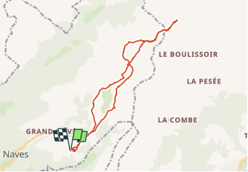
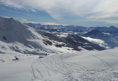
Trail Walking of 16.1 km to be discovered at Auvergne-Rhône-Alpes, Savoy, La Léchère. This trail is proposed by GuyVachet.
Description
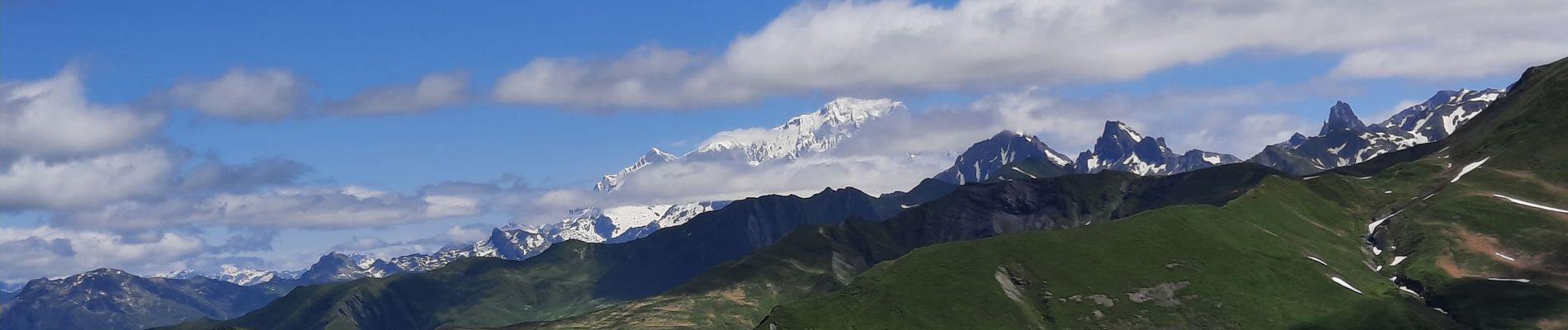
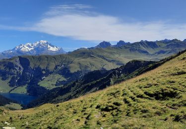
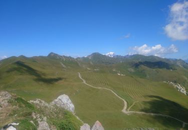
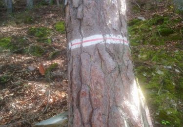
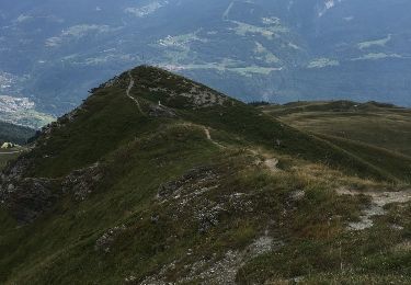
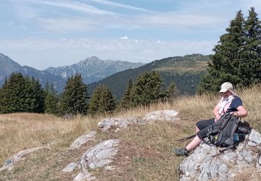
Montée au refuge du Nant du Beurre par un mixte de chemin empierré et de sentier et terminer par le sentier balcon pour passer au milieu des rhododendrons. Montée au Grand Crétet pour mieux apprécier le paysage laissé derrière nous puis enchainer la "descente" au Col des Tufs Blancs. Et juste au-dessus de ce col, vue s'ouvre sur la Vanoise de Péclet-Polset, en passant par les glaciers et la Grande Casse. Poursuite jusqu'au Col des Génisses avec le Mont-Blanc en ligne de mire pour ressentir le Beaufortain. Retour plus tranquille par le refuge puis revenir au point de départ, le parking de Tovet.
Positioning
Comments
Trails nearby
![Trail Walking La Léchère - lacs de la tempête - Photo](https://media.geolcdn.com/t/375/260/ext.jpg?maxdim=2&url=https%3A%2F%2Fmedia.geolcdn.com%2Ff%2F7ab3266a-90e4-4e18-93e8-1f9644da26a2.jpg)
![Walking Walking](https://static1.geolcdn.com/sitytour/trail-icons/101.png)
Walking
![](/images/other/stat-length.png)
![](https://static1.geolcdn.com/siteimages/upload/files/16400158638029165_repeat_loop_refresh_sync_direction_icon.png)
![Trail Walking Aime-la-Plagne - croix de tessins roche de janatan - Photo](https://media.geolcdn.com/t/375/260/ext.jpg?maxdim=2&url=https%3A%2F%2Fmedia.geolcdn.com%2Ff%2F70bd5170-f1a0-4370-a8a9-2bd84b4c62f8.jpg)
![Walking Walking](https://static1.geolcdn.com/sitytour/trail-icons/101.png)
Walking
![](/images/other/stat-length.png)
![](https://static1.geolcdn.com/siteimages/upload/files/16400158638029165_repeat_loop_refresh_sync_direction_icon.png)
![Trail Walking La Léchère - Tour du Quermoz par Grand Naves - Photo](https://media.geolcdn.com/t/375/260/ext.jpg?maxdim=2&url=https%3A%2F%2Fmedia.geolcdn.com%2Ff%2Fb6009670-ce5c-4d7e-9ab7-0ee7a59863d7.jpg)
![Walking Walking](https://static1.geolcdn.com/sitytour/trail-icons/101.png)
Walking
![](/images/other/stat-length.png)
![](https://static1.geolcdn.com/siteimages/upload/files/16400158638029165_repeat_loop_refresh_sync_direction_icon.png)
![Trail Walking La Léchère - Ronchat La Cudraz Navette Plan des Heures Balcon des Adrets de Tarentaise - Photo](https://media.geolcdn.com/t/375/260/ext.jpg?maxdim=2&url=https%3A%2F%2Fmedia.geolcdn.com%2Ff%2F31bbd3e5-7eb6-4ecd-afbb-fb24a4602b0f.jpg)
![Walking Walking](https://static1.geolcdn.com/sitytour/trail-icons/101.png)
Walking
![](/images/other/stat-length.png)
![](https://static1.geolcdn.com/siteimages/upload/files/16400158638029165_repeat_loop_refresh_sync_direction_icon.png)
![Trail Walking Aime-la-Plagne - Circuit par les cretes Dzonfie, Quermoz depuis La Combe. - Photo](https://media.geolcdn.com/t/375/260/ext.jpg?maxdim=2&url=https%3A%2F%2Fservices.sitytrail.com%2FGeolivesWS%2FDownloadMedia.ashx%3FTrailID%3D629822%26Media%3D20160910133917.jpg)
![Walking Walking](https://static1.geolcdn.com/sitytour/trail-icons/101.png)
Walking
![](/images/other/stat-length.png)
![](https://static1.geolcdn.com/siteimages/upload/files/16400158638029165_repeat_loop_refresh_sync_direction_icon.png)
![Trail Snowshoes La Léchère - poinye du dzonfie - Photo](https://media.geolcdn.com/t/375/260/ext.jpg?maxdim=2&url=https%3A%2F%2Fservices.sitytrail.com%2FGeolivesWS%2FDownloadMedia.ashx%3FTrailID%3D175759%26Media%3D20130218114702.jpeg)
![Snowshoes Snowshoes](https://static1.geolcdn.com/sitytour/trail-icons/504.png)
Snowshoes
![](/images/other/stat-length.png)
![](https://static1.geolcdn.com/siteimages/upload/files/16400158638029165_repeat_loop_refresh_sync_direction_icon.png)
![Trail Walking La Léchère - grand naves Beaufortain - Photo](https://media.geolcdn.com/t/375/260/ext.jpg?maxdim=2&url=https%3A%2F%2Fmedia.geolcdn.com%2Ff%2F0d5c1464-9afe-40cd-a3c1-52f7950d0659.jpg)
![Walking Walking](https://static1.geolcdn.com/sitytour/trail-icons/101.png)
Walking
![](/images/other/stat-length.png)
![](https://static1.geolcdn.com/siteimages/upload/files/16400158638029165_repeat_loop_refresh_sync_direction_icon.png)
![Trail Snowshoes La Léchère - Le grand Cretet depuis Grand Naves - Photo](https://media.geolcdn.com/t/375/260/ext.jpg?maxdim=2&url=https%3A%2F%2Fmedia.geolcdn.com%2Ff%2F761507e7-085e-4d3a-b710-a893c7fc28d0.jpg)
![Snowshoes Snowshoes](https://static1.geolcdn.com/sitytour/trail-icons/504.png)
Snowshoes
![](/images/other/stat-length.png)
![](https://static1.geolcdn.com/siteimages/upload/files/16400158638029165_repeat_loop_refresh_sync_direction_icon.png)
![Trail Walking Hautecour - bois de la mottaz - Photo](https://media.geolcdn.com/t/375/260/ext.jpg?maxdim=2&url=https%3A%2F%2Fstatic1.geolcdn.com%2Fsiteimages%2Fupload%2Ffiles%2F1553511878bg_sport_marche.png)
![Walking Walking](https://static1.geolcdn.com/sitytour/trail-icons/101.png)
Walking
![](/images/other/stat-length.png)
![](https://static1.geolcdn.com/siteimages/upload/files/16400158638029165_repeat_loop_refresh_sync_direction_icon.png)