Trail Walking Belvédère - Cime Niré - Photo
 bozo1970
bozo1970

User

© OpenStreetMap contributors
Length
Length
9.3 km
Max alt
Max alt
2622 m
Uphill gradient
Uphill gradient
928 m
Km-Effort
Km-Effort  
22 km
Min alt
Min alt
1686 m
Downhill gradient
Downhill gradient
928 m
Boucle
Boucle
Yes
Creation date :
2024-07-04 06:27:06.0
Updated on :
2024-07-04 19:05:02.504

(0 Reviews)

Walking
Walking
4h55
Difficulty : Very difficult

Scan this QR Code to open this trail in the SityTrail application

FREE GPS app for hiking

Logo SityTrail SityTrail

IGN / Geographical institutes

Download SityTrail from the App Store Download SityTrail from Google Play

Logo SityTrail SityTrail World

The world is yours!

Download SityTrail from the App Store Download SityTrail from Google Play Download SityTrail on Huawei AppGallery

About

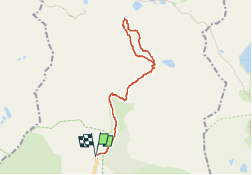
Trail Walking of 9.3 km to be discovered at Provence-Alpes-Côte d'Azur, Maritime Alps, Belvédère. This trail is proposed by bozo1970.

Description

Départ du Pont vers le lac Autier
1h12’ D 553m et 3km170
Hors sentier vers la Cîme Niré en remontant les vallons et traversant les barres
Escalade sur les 50 derniers mètres peu évident en 3h D 941 et 5km240’
Vue exceptionnelle à 360 du Neiglier au Grand Capelet en panoramique
Époustouflant 3 lacs Niré   Autier   La Fous
A/R en 4h52’ D 952 et10km

Elevation profile

Photos

Positioning

Country:
France
Region :
Provence-Alpes-Côte d'Azur
Department/Province :
Maritime Alps
Municipality :
Belvédère
Location:
Unknown
Start:(UTM)
371849 ; 4881316 (32T) N.

Trails nearby

Trail On foot Saint-Martin-Vésubie - SityTrail - Lacs de Prals - Photo
On foot
GUIDE
toutankhcarton

On foot

Easy
(1)
Saint-Martin-Vésubie, Provence-Alpes-Côte d'Azur, Maritime Alps, France
6.7 km | 13.6 km-effort
3h 5min
Yes
Trail On foot Tende - Tour du Grand Capelet - Etape 3 - Photo
On foot
GUIDE+

On foot

Easy
Tende, Provence-Alpes-Côte d'Azur, Maritime Alps, France
6.4 km | 12.9 km-effort
2h 56min
No
Trail On foot Belvédère - Les Merveilles par la Gordolasque - Photo
On foot
GUIDE+

On foot

Medium
Belvédère, Provence-Alpes-Côte d'Azur, Maritime Alps, France
13 km | 29 km-effort
6h 35min
Yes
Trail On foot Saint-Martin-Vésubie - Circuit de Fenestre - Photo
On foot
GUIDE+

On foot

Easy
Saint-Martin-Vésubie, Provence-Alpes-Côte d'Azur, Maritime Alps, France
8.1 km | 16.4 km-effort
3h 44min
Yes
Trail Walking Saint-Martin-Vésubie - Lacs de Prals - Photo
Walking
michlie

Walking

Easy
(1)
Saint-Martin-Vésubie, Provence-Alpes-Côte d'Azur, Maritime Alps, France
6.7 km | 13.5 km-effort
2h 48min
Yes
Trail Walking Tende - Valmasque- Bego-Pas de L'Autier-Countet - Photo
Walking
ch2slv

Walking

Difficult
(1)
Tende, Provence-Alpes-Côte d'Azur, Maritime Alps, France
16.9 km | 30 km-effort
5h 57min
No
Trail Other activity Saint-Martin-Vésubie - gr 52 merveilles - Photo
Other activity
legris

Other activity

Very easy
(1)
Saint-Martin-Vésubie, Provence-Alpes-Côte d'Azur, Maritime Alps, France
27 km | 53 km-effort
Unknown
No
Trail Walking Belvédère - Tête Nord du Basto  - Photo
Walking
bozo1970

Walking

Very difficult
Belvédère, Provence-Alpes-Côte d'Azur, Maritime Alps, France
10.4 km | 25 km-effort
5h 42min
Yes
Trail Walking Belvédère - Tête du Lac Autier - Photo
Walking
bozo1970

Walking

Very difficult
Belvédère, Provence-Alpes-Côte d'Azur, Maritime Alps, France
9.9 km | 24 km-effort
5h 54min
Yes


Close
My subscriptions