Trail Walking Villerest - Barrage Villerest-saint maurice - Photo

Barrage Villerest-saint maurice

 jenogues
jenogues

User

© OpenStreetMap contributors
Length
Length
621 km
Max alt
Max alt
667 m
Uphill gradient
Uphill gradient
9555 m
Km-Effort
Km-Effort  
749 km
Min alt
Min alt
-1 m
Downhill gradient
Downhill gradient
9790 m
Boucle
Boucle
No
Creation date :
2024-06-27 07:31:48.0
Updated on :
2024-07-01 18:37:26.12

(0 Reviews)

Walking
Walking
5h49
Difficulty : Medium

Scan this QR Code to open this trail in the SityTrail application

FREE GPS app for hiking

Logo SityTrail SityTrail

IGN / Geographical institutes

Download SityTrail from the App Store Download SityTrail from Google Play

Logo SityTrail SityTrail World

The world is yours!

Download SityTrail from the App Store Download SityTrail from Google Play Download SityTrail on Huawei AppGallery

About

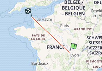
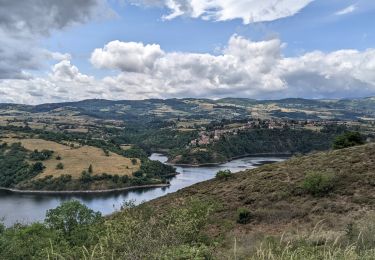
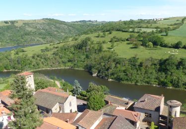
Trail Walking of 621 km to be discovered at Auvergne-Rhône-Alpes, Loire, Villerest. This trail is proposed by jenogues.

Description

Aller retour du barrage à st Maurice

Elevation profile

Positioning

Country:
France
Region :
Auvergne-Rhône-Alpes
Department/Province :
Loire
Municipality :
Villerest
Location:
Unknown
Start:(UTM)
580930 ; 5093184 (31T) N.

Trails nearby

Trail Mountain bike Commelle-Vernay - VTT dans le bois de Terrenoire et au bord du Rhins - Commelle Vernay - Photo
Mountain bike
tracegps

Mountain bike

Medium
(3)
Commelle-Vernay, Auvergne-Rhône-Alpes, Loire, France
35 km | 43 km-effort
3h 0min
Yes
Trail Walking Saint-Jean-Saint-Maurice-sur-Loire - Autour des Gorges de la Loire - PR N° 9 : Sur le pas des pèlerins - Saint-Jean-Saint-Maurice-sur-Loire - Photo
Walking
tracegps

Walking

Very difficult
(1)
Saint-Jean-Saint-Maurice-sur-Loire, Auvergne-Rhône-Alpes, Loire, France
14.2 km | 19.8 km-effort
4h 30min
Yes
Trail Walking Saint-Jean-Saint-Maurice-sur-Loire - Saint -Jean Saint -Maurice sur Loire  - Photo
Walking
dudu42

Walking

Medium
Saint-Jean-Saint-Maurice-sur-Loire, Auvergne-Rhône-Alpes, Loire, France
21 km | 26 km-effort
5h 4min
Yes
Trail Walking Saint-Cyr-de-Favières - Cordelle : Bois de Terrenoire  - Photo
Walking
Jgar

Walking

Medium
Saint-Cyr-de-Favières, Auvergne-Rhône-Alpes, Loire, France
6.4 km | 8.3 km-effort
1h 52min
Yes
Trail Walking Cordelle - boucle rilly-9.7 km - Photo
Walking
famillerudent

Walking

Difficult
Cordelle, Auvergne-Rhône-Alpes, Loire, France
9.7 km | 13.4 km-effort
2h 44min
Yes
Trail Walking Ouches - Ouches : de la plaine à la côte roannaise  - Photo
Walking
Jgar

Walking

Medium
Ouches, Auvergne-Rhône-Alpes, Loire, France
15.4 km | 21 km-effort
4h 37min
Yes
Trail Walking Cordelle - Cordelle : Terrenoire et versant sud - Photo
Walking
Jgar

Walking

Medium
Cordelle, Auvergne-Rhône-Alpes, Loire, France
12.1 km | 15.4 km-effort
3h 43min
Yes
Trail On foot Commelle-Vernay - Commelle-Vernay : petit train touristique - Photo
On foot
Jgar

On foot

Easy
Commelle-Vernay, Auvergne-Rhône-Alpes, Loire, France
7.3 km | 9.2 km-effort
2h 15min
Yes
Trail Walking Saint-Jean-Saint-Maurice-sur-Loire - St Jean-St Maurice 18km - Photo
Walking
GUIDE
thonyc

Walking

Difficult
Saint-Jean-Saint-Maurice-sur-Loire, Auvergne-Rhône-Alpes, Loire, France
18.3 km | 25 km-effort
5h 55min
Yes


Close
My subscriptions