![](/images/other/stat-length.png)
![Trail Walking Ostheim - Le long de la rivière Fecht à Ostheim en France - Photo](https://media.geolcdn.com/t/1900/400/ext.pjpeg?maxdim=2&url=https%3A%2F%2Fmedia.geolcdn.com%2Ff%2Fe49f18ff-da2a-44e2-88bc-a804e5f08011.jpeg)
Le long de la rivière Fecht à Ostheim en France
Benjamin27
User
![Length](/images/other/stat-length.png)
Length
2.3 km
![Max alt](https://static1.geolcdn.com/siteimages/upload/files/1508320355ic_sort_altitude_max_24dp.png)
Max alt
185 m
![Uphill gradient](https://static1.geolcdn.com/siteimages/upload/files/1508320355ic_sort_den_pos_24dp.png)
Uphill gradient
10 m
![Km-Effort](/images/other/stat-length.png)
Km-Effort
2.5 km
![Min alt](https://static1.geolcdn.com/siteimages/upload/files/1508320355ic_sort_altitude_min_24dp.png)
Min alt
176 m
![Downhill gradient](https://static1.geolcdn.com/siteimages/upload/files/1508320355ic_sort_den_neg_24dp.png)
Downhill gradient
11 m
![Boucle](https://static1.geolcdn.com/siteimages/upload/files/16400158638029165_repeat_loop_refresh_sync_direction_icon.png)
Boucle
Yes
Creation date :
2024-06-30 13:39:06.173
Updated on :
2024-06-30 13:47:29.089
![Walking](https://static1.geolcdn.com/sitytour/trail-icons/101.png)
33m
Difficulty : Easy
![Scan this QR Code to open this trail in the SityTrail application](https://capi.geolives.com/qq0zvz2zws4bq2lad0pu/sitytour/trails/4107538/qr.png?size=200)
FREE GPS app for hiking
About
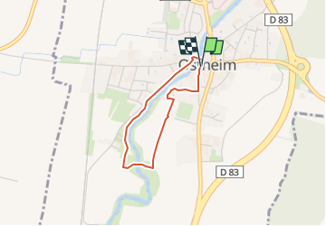
Trail Walking of 2.3 km to be discovered at Grand Est, Haut-Rhin, Ostheim. This trail is proposed by Benjamin27.
Description
Le long de la Fecht, vous sillonnerez ce joli petit village. Vous aurez la chance également de voir des cigognes, levez les yeux!
👣 Distance : 2,4km - balisage logo cigogne bleue.
📍Départ : au niveau de l’église catholique, rue Albert Schweitzer à 68150 Ostheim.
Positioning
Country:
France
Region :
Grand Est
Department/Province :
Haut-Rhin
Municipality :
Ostheim
Location:
Unknown
Start:(Dec)
Start:(UTM)
378812 ; 5335305 (32U) N.
Comments
Trails nearby
![Trail Mountain bike Ribeauvillé - Ribeauvillé Riquewihr - Photo](https://media.geolcdn.com/t/375/260/ext.jpg?maxdim=2&url=https%3A%2F%2Fservices.sitytrail.com%2FGeolivesWS%2FDownloadMedia.ashx%3FTrailID%3D101224%26Media%3D712_1.jpg)
![Mountain bike Mountain bike](https://static1.geolcdn.com/sitytour/trail-icons/202.png)
Ribeauvillé Riquewihr
Mountain bike
Medium
(1)
Ribeauvillé,
Grand Est,
Haut-Rhin,
France
![](/images/other/stat-length.png)
19.3 km | 24 km-effort
1h 30min
![](https://static1.geolcdn.com/siteimages/upload/files/16400158638029165_repeat_loop_refresh_sync_direction_icon.png)
Yes
![Trail Walking Hunawihr - Hunawihr - Riquewihr - Photo](https://media.geolcdn.com/t/375/260/ext.jpg?maxdim=2&url=https%3A%2F%2Fstatic1.geolcdn.com%2Fsiteimages%2Fupload%2Ffiles%2F1553511878bg_sport_marche.png)
![Walking Walking](https://static1.geolcdn.com/sitytour/trail-icons/101.png)
Hunawihr - Riquewihr
Walking
Easy
(1)
Hunawihr,
Grand Est,
Haut-Rhin,
France
![](/images/other/stat-length.png)
6.3 km | 9 km-effort
2h 15min
![](https://static1.geolcdn.com/siteimages/upload/files/16400158638029165_repeat_loop_refresh_sync_direction_icon.png)
Yes
![Trail Horseback riding Kaysersberg-Vignoble - 000004 - Photo](https://media.geolcdn.com/t/375/260/ext.jpg?maxdim=2&url=https%3A%2F%2Fmedia.geolcdn.com%2Ff%2Ffc80041c-b401-476e-a019-02f21cb51a95.jpg)
![Horseback riding Horseback riding](https://static1.geolcdn.com/sitytour/trail-icons/301.png)
000004
Horseback riding
Very difficult
Kaysersberg-Vignoble,
Grand Est,
Haut-Rhin,
France
![](/images/other/stat-length.png)
32 km | 45 km-effort
5h 55min
![](https://static1.geolcdn.com/siteimages/upload/files/16400158638029165_repeat_loop_refresh_sync_direction_icon.png)
Yes
![Trail Walking Riquewihr - Sentier des grands crus - Photo](https://media.geolcdn.com/t/375/260/ext.jpg?maxdim=2&url=https%3A%2F%2Fservices.sitytrail.com%2FGeolivesWS%2FDownloadMedia.ashx%3FTrailID%3D482185%26Media%3D8532cb29-bcf9-4719-bd1f-5f2e4165e237.jpg)
![Walking Walking](https://static1.geolcdn.com/sitytour/trail-icons/101.png)
Sentier des grands crus
Walking
Medium
(2)
Riquewihr,
Grand Est,
Haut-Rhin,
France
![](/images/other/stat-length.png)
11.5 km | 14.4 km-effort
3h 7min
![](https://static1.geolcdn.com/siteimages/upload/files/16400158638029165_repeat_loop_refresh_sync_direction_icon.png)
Yes
![Trail Walking Mittelwihr - Mittelwihr - Beblenheim - Zellenberg - Hunawihr - Riquewihr - Nécropole de Sigolsheim - Photo](https://media.geolcdn.com/t/375/260/ext.jpg?maxdim=2&url=https%3A%2F%2Fmedia.geolcdn.com%2Ff%2F270dee57-4c57-4155-999a-3cb2b93f05a0.jpg)
![Walking Walking](https://static1.geolcdn.com/sitytour/trail-icons/101.png)
Mittelwihr - Beblenheim - Zellenberg - Hunawihr - Riquewihr - Nécropole de ...
Walking
Medium
Mittelwihr,
Grand Est,
Haut-Rhin,
France
![](/images/other/stat-length.png)
14.5 km | 19.3 km-effort
4h 8min
![](https://static1.geolcdn.com/siteimages/upload/files/16400158638029165_repeat_loop_refresh_sync_direction_icon.png)
Yes
![Trail Walking Mittelwihr - Mittelwihr - Nécropole de Sigolsheim - Riquewihr - Hunawihr - Zellenberg - Photo](https://media.geolcdn.com/t/375/260/ext.jpg?maxdim=2&url=https%3A%2F%2Fmedia.geolcdn.com%2Ff%2F10a16fa9-0020-48fe-b312-53bccae47e63.jpg)
![Walking Walking](https://static1.geolcdn.com/sitytour/trail-icons/101.png)
Mittelwihr - Nécropole de Sigolsheim - Riquewihr - Hunawihr - Zellenberg
Walking
Medium
(1)
Mittelwihr,
Grand Est,
Haut-Rhin,
France
![](/images/other/stat-length.png)
15.1 km | 19.8 km-effort
5h 37min
![](https://static1.geolcdn.com/siteimages/upload/files/16400158638029165_repeat_loop_refresh_sync_direction_icon.png)
Yes
![Trail Walking Ribeauvillé - Ribeauvillé et ses 3 châteaux - Monastère ND de Dusenbach - Photo](https://media.geolcdn.com/t/375/260/ext.jpg?maxdim=2&url=https%3A%2F%2Fmedia.geolcdn.com%2Ff%2F659b28d5-00d0-49c5-98dc-339b4ec6bb7e.jpg)
![Walking Walking](https://static1.geolcdn.com/sitytour/trail-icons/101.png)
Ribeauvillé et ses 3 châteaux - Monastère ND de Dusenbach
Walking
Difficult
Ribeauvillé,
Grand Est,
Haut-Rhin,
France
![](/images/other/stat-length.png)
12.1 km | 22 km-effort
3h 9min
![](https://static1.geolcdn.com/siteimages/upload/files/16400158638029165_repeat_loop_refresh_sync_direction_icon.png)
No
![Trail Walking Mittelwihr - entre vignobles et forêts : boucle Mittelwihr- Bebleheim- Zellenberg - Hunawihr - Riquewihr- Mittelwihr - Photo](https://media.geolcdn.com/t/375/260/ext.jpg?maxdim=2&url=https%3A%2F%2Fmedia.geolcdn.com%2Ff%2F0117ff8d-f4e8-4645-b617-43247b526892.jpg)
![Walking Walking](https://static1.geolcdn.com/sitytour/trail-icons/101.png)
entre vignobles et forêts : boucle Mittelwihr- Bebleheim- Zellenberg - Hunawi...
Walking
Easy
Mittelwihr,
Grand Est,
Haut-Rhin,
France
![](/images/other/stat-length.png)
15.9 km | 22 km-effort
3h 53min
![](https://static1.geolcdn.com/siteimages/upload/files/16400158638029165_repeat_loop_refresh_sync_direction_icon.png)
Yes
![Trail Walking Porte-du-Ried - Sur les sentiers d'Holtzwihr et de Riedwihr - Photo](https://media.geolcdn.com/t/375/260/ext.jpg?maxdim=2&url=https%3A%2F%2Fmedia.geolcdn.com%2Ff%2F6928e266-2e52-49c8-9ebd-9a70ab6a481f.jpg)
![Walking Walking](https://static1.geolcdn.com/sitytour/trail-icons/101.png)
Sur les sentiers d'Holtzwihr et de Riedwihr
Walking
Very easy
Porte-du-Ried,
Grand Est,
Haut-Rhin,
France
![](/images/other/stat-length.png)
16.6 km | 18.2 km-effort
3h 12min
![](https://static1.geolcdn.com/siteimages/upload/files/16400158638029165_repeat_loop_refresh_sync_direction_icon.png)
Yes