Trail Walking Pontechianale - ITALIE BELLINO CHIANALE . TOUR DU PAIN DU SUCRE . AR. O  - Photo

ITALIE BELLINO CHIANALE . TOUR DU PAIN DU SUCRE . AR. O

© OpenStreetMap contributors
Length
Length
7.7 km
Max alt
Max alt
2254 m
Uphill gradient
Uphill gradient
271 m
Km-Effort
Km-Effort  
11.3 km
Min alt
Min alt
2004 m
Downhill gradient
Downhill gradient
276 m
Boucle
Boucle
Yes
Creation date :
2024-06-28 07:04:23.104
Updated on :
2024-07-01 08:16:00.445

(0 Reviews)

Walking
Walking
2h36
Difficulty : Medium

Scan this QR Code to open this trail in the SityTrail application

FREE GPS app for hiking

Logo SityTrail SityTrail

IGN / Geographical institutes

Download SityTrail from the App Store Download SityTrail from Google Play

Logo SityTrail SityTrail World

The world is yours!

Download SityTrail from the App Store Download SityTrail from Google Play Download SityTrail on Huawei AppGallery

About

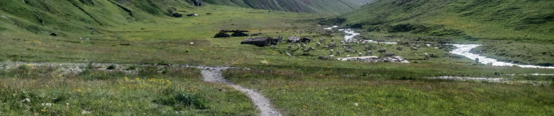
Trail Walking of 7.7 km to be discovered at Piemont, Cuneo, Pontechianale. This trail is proposed by RobinMicheline.

Description

AR PAS PU TRAVERSER TORRENT . PAS PU ALLER JUSQU AU REFUGE CAGLIARDONE

Elevation profile

Photos

Positioning

Country:
Italy
Region :
Piemont
Department/Province :
Cuneo
Municipality :
Pontechianale
Location:
Unknown
Start:(UTM)
340870 ; 4947378 (32T) N.

Trails nearby

Trail On foot Pontechianale - (SI E21) Pontechianale, Borgata Maddalena - Rifugio Quintino Sella - Photo
On foot
PRO

On foot

Medium
Pontechianale, Piemont, Cuneo, Italy
14.1 km | 28 km-effort
6h 25min
No
Trail Walking Molines-en-Queyras - le tour du Pain de Sucre - Photo
Walking
GUIDE
amiral13

Walking

Difficult
Molines-en-Queyras, Provence-Alpes-Côte d'Azur, Hautes-Alpes, France
8.1 km | 16 km-effort
4h 57min
Yes
Trail Walking Molines-en-Queyras - Lacs Foréant, Egorgéou, Baricle et de l'Eychassier - Photo
Walking
GUIDE
amiral13

Walking

Medium
Molines-en-Queyras, Provence-Alpes-Côte d'Azur, Hautes-Alpes, France
13.8 km | 24 km-effort
6h 20min
Yes
Trail Walking Molines-en-Queyras - le pain de sucre - Photo
Walking
GUIDE
amiral13

Walking

Difficult
(1)
Molines-en-Queyras, Provence-Alpes-Côte d'Azur, Hautes-Alpes, France
4.5 km | 10.1 km-effort
4h 39min
Yes
Trail Walking Pontechianale - pain de sucre circuit  - Photo
Walking
Youcef Atallah

Walking

Medium
Pontechianale, Piemont, Cuneo, Italy
5.9 km | 11.9 km-effort
2h 12min
No
Trail Walking Molines-en-Queyras - Pic Foréant et Col d'Asti - Photo
Walking
PapouBertrand

Walking

Very difficult
Molines-en-Queyras, Provence-Alpes-Côte d'Azur, Hautes-Alpes, France
11.8 km | 24 km-effort
7h 14min
No
Trail Walking Molines-en-Queyras - 05-Pain-de-sucre-6.5km-525m-aout21 - Photo
Walking
SyMA

Walking

Medium
Molines-en-Queyras, Provence-Alpes-Côte d'Azur, Hautes-Alpes, France
6.5 km | 13.5 km-effort
4h 14min
Yes
Trail Walking Molines-en-Queyras - Refuge Agnel-lac Foreant-col Agnel 23 07 2020 - Photo
Walking
Hugues Michel

Walking

Medium
Molines-en-Queyras, Provence-Alpes-Côte d'Azur, Hautes-Alpes, France
8.2 km | 14.8 km-effort
3h 20min
Yes
Trail Walking Molines-en-Queyras - Tour du Viso J6 - Le Pain de sucre - Photo
Walking
patjobou

Walking

Difficult
Molines-en-Queyras, Provence-Alpes-Côte d'Azur, Hautes-Alpes, France
7 km | 14.7 km-effort
4h 30min
Yes


Close
My subscriptions