Trail Motorbike Évette-Salbert - Moto - Evette - Grand Ballon - Nonneck - Lacs de Longemer puis de Gérardmer - chapelle des Vés - Ballon d'Alsace - Photo

Moto - Evette - Grand Ballon - Nonneck - Lacs de Longemer puis de Gérardmer - chapelle des Vés - Ballon d'Alsace

 Bart2015
Bart2015

User

© OpenStreetMap contributors
Length
Length
195 km
Max alt
Max alt
1339 m
Uphill gradient
Uphill gradient
4277 m
Km-Effort
Km-Effort  
252 km
Min alt
Min alt
355 m
Downhill gradient
Downhill gradient
4278 m
Boucle
Boucle
Yes
Creation date :
2024-06-27 08:01:13.956
Updated on :
2024-06-28 06:35:33.937

(0 Reviews)

Motorbike
Motorbike
5h39
Difficulty : Difficult

Scan this QR Code to open this trail in the SityTrail application

FREE GPS app for hiking

Logo SityTrail SityTrail

IGN / Geographical institutes

Download SityTrail from the App Store Download SityTrail from Google Play

Logo SityTrail SityTrail World

The world is yours!

Download SityTrail from the App Store Download SityTrail from Google Play Download SityTrail on Huawei AppGallery

About

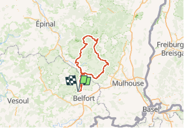
Trail Motorbike of 195 km to be discovered at Bourgogne-Franche-Comté, Territoire-de-Belfort, Évette-Salbert. This trail is proposed by Bart2015.

Description

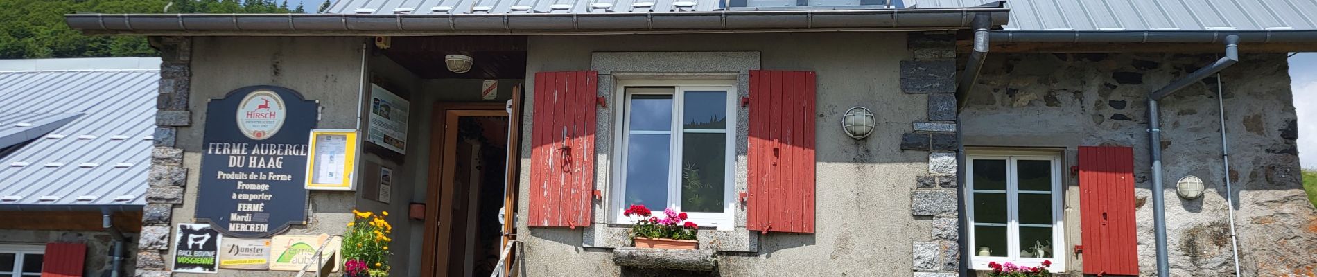
Petite halte à la ferme auberge du Haag : excellent, réservation conseillée.
Bonne balade, soyez prudent ...

Elevation profile

Photos

Positioning

Country:
France
Region :
Bourgogne-Franche-Comté
Department/Province :
Territoire-de-Belfort
Municipality :
Évette-Salbert
Location:
Unknown
Start:(UTM)
335319 ; 5283234 (32T) N.

Trails nearby

Trail Walking Belfort - Offemont - La ballade des Champs Cerisiers - Photo
Walking
bmorel@orange.fr

Walking

Easy
(1)
Belfort, Bourgogne-Franche-Comté, Territoire-de-Belfort, France
8.8 km | 10.8 km-effort
Unknown
Yes
Trail Walking Sermamagny - Veronne PC - Photo
Walking
Papamoju

Walking

Very easy
(2)
Sermamagny, Bourgogne-Franche-Comté, Territoire-de-Belfort, France
8.1 km | 9 km-effort
1h 59min
Yes
Trail Walking Châlonvillars - Châlonvillars - Fort du Salbert - Evette-Salbert - Photo
Walking
Bart2015

Walking

Difficult
(1)
Châlonvillars, Bourgogne-Franche-Comté, Haute-Saône, France
11 km | 15.8 km-effort
3h 36min
Yes
Trail Walking Châlonvillars - Châlonvillars - le mehnir - Mandrevillars - Photo
Walking
Bart2015

Walking

Medium
Châlonvillars, Bourgogne-Franche-Comté, Haute-Saône, France
13.4 km | 17.1 km-effort
2h 39min
Yes
Trail Walking Châlonvillars - Châlonvillars - Mandrevillars - Photo
Walking
Bart2015

Walking

Easy
Châlonvillars, Bourgogne-Franche-Comté, Haute-Saône, France
9.5 km | 11.9 km-effort
1h 33min
Yes
Trail Walking Châlonvillars - Châlonvillars - Mandrevillars par les bois - Photo
Walking
Bart2015

Walking

Easy
Châlonvillars, Bourgogne-Franche-Comté, Haute-Saône, France
10.4 km | 12.9 km-effort
1h 40min
Yes
Trail Walking Châlonvillars - Châlonvillars - les étangs - fort du Salbert - grottes Cravanche - Photo
Walking
Bart2015

Walking

Medium
Châlonvillars, Bourgogne-Franche-Comté, Haute-Saône, France
13.2 km | 20 km-effort
2h 46min
Yes
Trail Horseback riding Lachapelle-sous-Chaux - Lachapelle-sous-chaux / Planche des belles filles - Photo
Horseback riding
battaglia

Horseback riding

Difficult
(1)
Lachapelle-sous-Chaux, Bourgogne-Franche-Comté, Territoire-de-Belfort, France
25 km | 37 km-effort
4h 26min
Yes
Trail Walking Châlonvillars - Chalonvillars - fort du Salbert  - Photo
Walking
Bart2015

Walking

Easy
Châlonvillars, Bourgogne-Franche-Comté, Haute-Saône, France
9.7 km | 14.1 km-effort
2h 27min
Yes


Close
My subscriptions