Trail Walking Vinadio - santa anna - Photo

santa anna

© OpenStreetMap contributors
Length
Length
11.7 km
Max alt
Max alt
2455 m
Uphill gradient
Uphill gradient
613 m
Km-Effort
Km-Effort  
19.9 km
Min alt
Min alt
2017 m
Downhill gradient
Downhill gradient
620 m
Boucle
Boucle
Yes
Creation date :
2024-06-26 06:34:04.223
Updated on :
2024-06-26 12:54:27.849

(0 Reviews)

Walking
Walking
3h50
Difficulty : Medium

Scan this QR Code to open this trail in the SityTrail application

FREE GPS app for hiking

Logo SityTrail SityTrail

IGN / Geographical institutes

Download SityTrail from the App Store Download SityTrail from Google Play

Logo SityTrail SityTrail World

The world is yours!

Download SityTrail from the App Store Download SityTrail from Google Play Download SityTrail on Huawei AppGallery

About

Trail Walking of 11.7 km to be discovered at Piemont, Cuneo, Vinadio. This trail is proposed by jack.cavelier@orange.fr.

Elevation profile

Positioning

Country:
Italy
Region :
Piemont
Department/Province :
Cuneo
Municipality :
Vinadio
Location:
Unknown
Start:(UTM)
348676 ; 4899409 (32T) N.

Trails nearby

Trail On foot Vinadio - Tour du Lausfer - Photo
On foot
PRO

On foot

Easy
Vinadio, Piemont, Cuneo, Italy
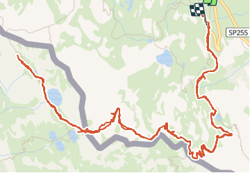
9.5 km | 16.7 km-effort
3h 47min
Yes
Trail On foot Vinadio - (SI E13) Sant'Anna di Vinadio - Vinadio Frazione Strepeis - Photo
On foot
PRO

On foot

Easy
Vinadio, Piemont, Cuneo, Italy
9.1 km | 16.1 km-effort
3h 40min
No
Trail Walking Vinadio - Cime de la Lombarde 2800m 26.8.24 - Photo
Walking
GUIDE
fredetpascale

Walking

Very difficult
Vinadio, Piemont, Cuneo, Italy
3.4 km | 9.1 km-effort
2h 30min
Yes
Trail Walking Vinadio - Tour du Lausfer 25.8.24 - Photo
Walking
GUIDE
fredetpascale

Walking

Medium
Vinadio, Piemont, Cuneo, Italy
9 km | 16.2 km-effort
3h 30min
Yes
Trail sport Vinadio - Lacs de laisser - Photo
sport
GUIDE
jouans

sport

Very easy
Vinadio, Piemont, Cuneo, Italy
12.4 km | 21 km-effort
Unknown
Yes
Trail Snowshoes Isola - Mont St Sauveur  - Photo
Snowshoes
bozo1970

Snowshoes

Difficult
Isola, Provence-Alpes-Côte d'Azur, Maritime Alps, France
8.7 km | 20 km-effort
3h 52min
Yes
Trail Walking Isola - Lacs du Lausfer / pas de Ste Anne - Photo
Walking
bozo1970

Walking

Easy
Isola, Provence-Alpes-Côte d'Azur, Maritime Alps, France
9.7 km | 20 km-effort
3h 9min
Yes
Trail Walking Isola - Cime Moravachère Est - Photo
Walking
bozo1970

Walking

Easy
Isola, Provence-Alpes-Côte d'Azur, Maritime Alps, France
8.6 km | 12.2 km-effort
2h 32min
Yes
Trail Walking Isola - Cîme de Sistron - Photo
Walking
bozo1970

Walking

Medium
Isola, Provence-Alpes-Côte d'Azur, Maritime Alps, France
10.2 km | 21 km-effort
3h 27min
Yes


Close
My subscriptions