Trail Walking Isola - Fontaine St Laurent par Collet de Léchio et Cascade de Louch Isola Village - Photo

Fontaine St Laurent par Collet de Léchio et Cascade de Louch Isola Village

 GrouGary
GrouGary

User

© OpenStreetMap contributors
Length
Length
9.5 km
Max alt
Max alt
1342 m
Uphill gradient
Uphill gradient
510 m
Km-Effort
Km-Effort  
16.3 km
Min alt
Min alt
856 m
Downhill gradient
Downhill gradient
505 m
Boucle
Boucle
Yes
Creation date :
2024-06-22 07:15:10.014
Updated on :
2024-06-23 06:54:02.452

(0 Reviews)

Walking
Walking
4h44
Difficulty : Easy

Scan this QR Code to open this trail in the SityTrail application

FREE GPS app for hiking

Logo SityTrail SityTrail

IGN / Geographical institutes

Download SityTrail from the App Store Download SityTrail from Google Play

Logo SityTrail SityTrail World

The world is yours!

Download SityTrail from the App Store Download SityTrail from Google Play Download SityTrail on Huawei AppGallery

About

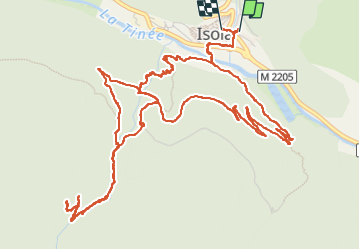
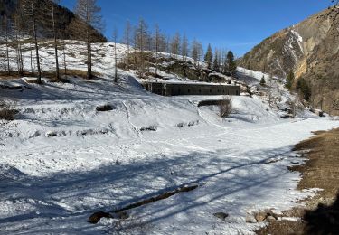
Trail Walking of 9.5 km to be discovered at Provence-Alpes-Côte d'Azur, Maritime Alps, Isola. This trail is proposed by GrouGary.

Description

L'essentiel des dénivelés se fait dans la première partie, immédiatement après la traversée de la Tinée ;
Montée un peu sévère pour passer le long de la cascade de Louch mais qui mérite le détour après les fortes pluies de printemps.
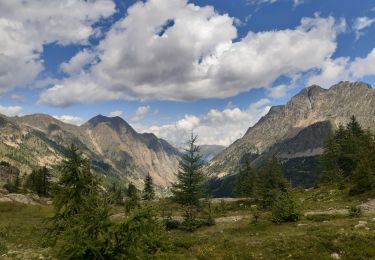
Le reste de la rando se fait essentiellement en sentiers très praticables jusqu'aux bergeries au-dessus du Vallon de Louch ;
Au-delà, la sente pour le Collet de Léchio puis la Fontaine St Laurent est peu visible, les traces de balisages jaunes très effacées. La rando reste cependant ouverte, sans couvert forestier ni densité de végétation, ce qui la rend probablement possible, sans difficulté, jusqu'à la Fontaine St Laurent (pour une autre fois...)

Elevation profile

Photos

24 photos in total. Please click on a photo to see them all in the gallery.

Positioning

Country:
France
Region :
Provence-Alpes-Côte d'Azur
Department/Province :
Maritime Alps
Municipality :
Isola
Location:
Unknown
Start:(UTM)
344470 ; 4894396 (32T) N.

Trails nearby

Trail Walking Isola - Châtaigneraie ISOLA - Photo
Walking
jpnice06

Walking

Very easy
(1)
Isola, Provence-Alpes-Côte d'Azur, Maritime Alps, France
4.4 km | 7.1 km-effort
2h 9min
Yes
Trail Walking Isola - Lacs du Lausfer / pas de Ste Anne - Photo
Walking
bozo1970

Walking

Easy
Isola, Provence-Alpes-Côte d'Azur, Maritime Alps, France
9.7 km | 20 km-effort
3h 9min
Yes
Trail Walking Isola - Cimes et lacs de Lausfer  - Photo
Walking
domi06

Walking

Difficult
Isola, Provence-Alpes-Côte d'Azur, Maritime Alps, France
10.8 km | 23 km-effort
6h 6min
Yes
Trail Walking Vinadio -  St Anna di Vinadio - Photo
Walking
GrouGary

Walking

Easy
Vinadio, Piemont, Cuneo, Italy
9.6 km | 16.4 km-effort
3h 30min
Yes
Trail Walking Isola - Pas de St Anne - Photo
Walking
bozo1970

Walking

Easy
Isola, Provence-Alpes-Côte d'Azur, Maritime Alps, France
5.5 km | 13.4 km-effort
2h 35min
Yes
Trail On foot Isola - Boucle de Louch - Photo
On foot
PRO

On foot

Easy
Isola, Provence-Alpes-Côte d'Azur, Maritime Alps, France
4.6 km | 9.3 km-effort
2h 6min
Yes
Trail Walking Isola - Col de la Guercha - Photo
Walking
bozo1970

Walking

Very difficult
Isola, Provence-Alpes-Côte d'Azur, Maritime Alps, France
11.3 km | 27 km-effort
5h 4min
Yes
Trail Walking Isola - Isola - lac et cime de Lausfer - Photo
Walking
ETMU5496

Walking

Difficult
Isola, Provence-Alpes-Côte d'Azur, Maritime Alps, France
12.2 km | 24 km-effort
4h 9min
Yes
Trail Walking Isola - Chapelle Ste Eurosie - Photo
Walking
domi06

Walking

Medium
Isola, Provence-Alpes-Côte d'Azur, Maritime Alps, France
6.9 km | 17.6 km-effort
4h 44min
Yes


Close
My subscriptions