![](/images/other/stat-length.png)
![Trail Walking Ault - Les falaises d’Ault - Photo](https://media.geolcdn.com/t/1900/400/ext.pjpeg?maxdim=2&url=https%3A%2F%2Fstatic1.geolcdn.com%2Fsiteimages%2Fupload%2Ffiles%2F1553511878bg_sport_marche.png)
Les falaises d’Ault
dboon
User
![Length](/images/other/stat-length.png)
![Max alt](https://static1.geolcdn.com/siteimages/upload/files/1508320355ic_sort_altitude_max_24dp.png)
![Uphill gradient](https://static1.geolcdn.com/siteimages/upload/files/1508320355ic_sort_den_pos_24dp.png)
![Km-Effort](/images/other/stat-length.png)
![Min alt](https://static1.geolcdn.com/siteimages/upload/files/1508320355ic_sort_altitude_min_24dp.png)
![Downhill gradient](https://static1.geolcdn.com/siteimages/upload/files/1508320355ic_sort_den_neg_24dp.png)
![Boucle](https://static1.geolcdn.com/siteimages/upload/files/16400158638029165_repeat_loop_refresh_sync_direction_icon.png)
![Walking](https://static1.geolcdn.com/sitytour/trail-icons/101.png)
3h19
Difficulty : Medium
![Scan this QR Code to open this trail in the SityTrail application](https://capi.geolives.com/qq0zvz2zws4bq2lad0pu/sitytour/trails/4099128/qr.png?size=200)
FREE GPS app for hiking
About
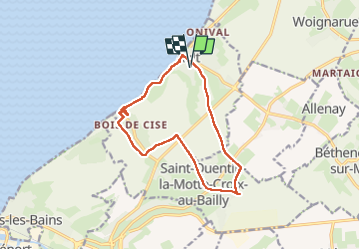
Trail Walking of 12.2 km to be discovered at Hauts-de-France, Somme, Ault. This trail is proposed by dboon.
Description
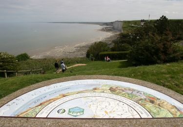
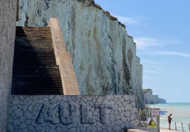
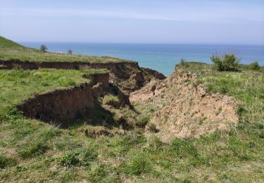
Découvrez le site où commencent les falaises de la Côte d'Albâtre.
Dominez la mer du haut de l'imposante falaise blanche, paisible verdure du seul bois naturel de la côte, traversée d'un bourg au nom interminable : rien ne manque à cette agréable randonnée.
1 - Au Bois de Cise, sur l'Avenue, prendre l'Allée du Muguet pour remonter jusqu'au chemin du Grand Mont puis prendre à gauche.
2 - Reprendre la Grande Avenue du Bois de Cise jusqu'à la route. Au stop de la D63, prendre Saint-Quentin-Lamotte.
3 - Effectuer un crochet gauche-droite sur 20m. S'engager dans la ruelle puis traverser la rue du Moulin et continuer en face, rue des Casernes.
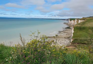
Le Bois de Cise : A mi-chemin de votre parcours, vous traverserez cette perle de verdure, un bois maritime naturel situé au creux d'une valleuse suspendue.
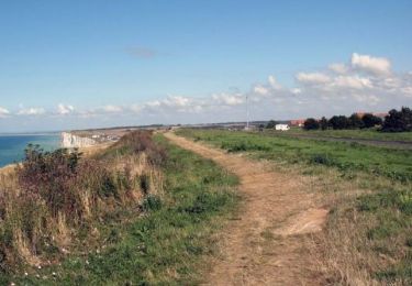
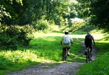
Une rando, ça se partage et celle-ci est idéale pour garder des souvenirs communs comme la surprise de voir surgir le bois de Cise au milieu des falaises ou le phare de Ault perché "tout là-haut" ou encore de voir s'afficher sur un panneau le plus long nom de village de France ! Si vous êtes fans de rando, poursuivez au nord ou au sud sur le sentier du littoral; sinon, une pause réconfortante à Ault à la Flibustière pour déguster de bonnes bières artisanales !
Sûrement l'une des plus belles balades du littoral pour surprendre votre moitié! Points de vue sur la mer à couper le souffle du haut des falaises, détours au cœur des cheminements du bois de Cise pour plus d'intimité, bleus du ciel et de la mer, vert nature des prairies et des sous-bois, odeur des embruns et des fleurs : cocktail gagnant pour passer un moment privilégié avec votre cher(e) et tendre ! N'oubliez pas dans votre sac, une petite douceur pour la pause et tout sera parfait !
Possibilité de se restaurer sur une table à proximité de la mairie de St Quentin la Motte Croix au Bailly.
Positioning
Comments
Trails nearby
![Trail Walking Mers-les-Bains - Mers les bains - Bois de Cise 10/08/2021 - Photo](https://media.geolcdn.com/t/375/260/5f1823c0-09ad-4077-a160-bafc5864d002.jpg&format=jpg&maxdim=2)
![Walking Walking](https://static1.geolcdn.com/sitytour/trail-icons/101.png)
Walking
![](/images/other/stat-length.png)
![](https://static1.geolcdn.com/siteimages/upload/files/16400158638029165_repeat_loop_refresh_sync_direction_icon.png)
![Trail Walking Le Tréport - La plaine de La Falaise - Le Tréport - Photo](https://media.geolcdn.com/t/375/260/ext.jpg?maxdim=2&url=https%3A%2F%2Fservices.sitytrail.com%2FGeolivesWS%2FDownloadMedia.ashx%3FTrailID%3D118751%26Media%3D12947_3.jpg)
![Walking Walking](https://static1.geolcdn.com/sitytour/trail-icons/101.png)
Walking
![](/images/other/stat-length.png)
![](https://static1.geolcdn.com/siteimages/upload/files/16400158638029165_repeat_loop_refresh_sync_direction_icon.png)
![Trail Walking Mers-les-Bains - La falaise - Mers les Bains - Photo](https://media.geolcdn.com/t/375/260/ext.jpg?maxdim=2&url=https%3A%2F%2Fservices.sitytrail.com%2FGeolivesWS%2FDownloadMedia.ashx%3FTrailID%3D108613%26Media%3D1522_1.jpg)
![Walking Walking](https://static1.geolcdn.com/sitytour/trail-icons/101.png)
Walking
![](/images/other/stat-length.png)
![](https://static1.geolcdn.com/siteimages/upload/files/16400158638029165_repeat_loop_refresh_sync_direction_icon.png)
![Trail Walking Ault - Circuit de Lamotte - Photo](https://media.geolcdn.com/t/375/260/ext.jpg?maxdim=2&url=https%3A%2F%2Fservices.sitytrail.com%2FGeolivesWS%2FDownloadMedia.ashx%3FTrailID%3D108612%26Media%3D1521_1.jpg)
![Walking Walking](https://static1.geolcdn.com/sitytour/trail-icons/101.png)
Walking
![](/images/other/stat-length.png)
![](https://static1.geolcdn.com/siteimages/upload/files/16400158638029165_repeat_loop_refresh_sync_direction_icon.png)
![Trail Walking Ault - Les huttes - Photo](https://media.geolcdn.com/t/375/260/ext.jpg?maxdim=2&url=https%3A%2F%2Fservices.sitytrail.com%2FGeolivesWS%2FDownloadMedia.ashx%3FTrailID%3D108611%26Media%3D1520_1.jpg)
![Walking Walking](https://static1.geolcdn.com/sitytour/trail-icons/101.png)
Walking
![](/images/other/stat-length.png)
![](https://static1.geolcdn.com/siteimages/upload/files/16400158638029165_repeat_loop_refresh_sync_direction_icon.png)
![Trail Walking Ault - Ault - Treport - Photo](https://media.geolcdn.com/t/375/260/84cea69d-8d56-4a12-8748-3e18fd9b9bc4.jpg&format=jpg&maxdim=2)
![Walking Walking](https://static1.geolcdn.com/sitytour/trail-icons/101.png)
Walking
![](/images/other/stat-length.png)
![](https://static1.geolcdn.com/siteimages/upload/files/16400158638029165_repeat_loop_refresh_sync_direction_icon.png)
![Trail Road bike Le Tréport - Circuit vélo Le Tréport Gamach - Photo](https://media.geolcdn.com/t/375/260/ce18cb47-2255-4f59-9ac9-d5dd0e93105b.jpg&format=jpg&maxdim=2)
![Road bike Road bike](https://static1.geolcdn.com/sitytour/trail-icons/201.png)
Road bike
![](/images/other/stat-length.png)
![](https://static1.geolcdn.com/siteimages/upload/files/16400158638029165_repeat_loop_refresh_sync_direction_icon.png)
![Trail Walking Ault - Normandie 2022 : Ault - Mers les bains - Photo](https://media.geolcdn.com/t/375/260/321e4766-200f-421b-ba94-e0505c3d4eba.jpg&format=jpg&maxdim=2)
![Walking Walking](https://static1.geolcdn.com/sitytour/trail-icons/101.png)
Walking
![](/images/other/stat-length.png)
![](https://static1.geolcdn.com/siteimages/upload/files/16400158638029165_repeat_loop_refresh_sync_direction_icon.png)
![Trail Mountain bike Le Tréport - Chemin des étangs de la vallée de la Bresle - Le Tréport - Photo](https://media.geolcdn.com/t/375/260/ext.jpg?maxdim=2&url=https%3A%2F%2Fservices.sitytrail.com%2FGeolivesWS%2FDownloadMedia.ashx%3FTrailID%3D191644%26Media%3D15291_5.jpg)
![Mountain bike Mountain bike](https://static1.geolcdn.com/sitytour/trail-icons/202.png)
Mountain bike
![](/images/other/stat-length.png)
![](https://static1.geolcdn.com/siteimages/upload/files/16400158638029165_repeat_loop_refresh_sync_direction_icon.png)