Trail Moto cross Lanuéjols - recos rando 22 juin - Photo

recos rando 22 juin

© OpenStreetMap contributors
Length
Length
103 km
Max alt
Max alt
1486 m
Uphill gradient
Uphill gradient
3158 m
Km-Effort
Km-Effort  
145 km
Min alt
Min alt
573 m
Downhill gradient
Downhill gradient
3157 m
Boucle
Boucle
Yes
Creation date :
2024-06-22 07:12:24.886
Updated on :
2024-06-22 12:53:01.659

(0 Reviews)

Moto cross
Moto cross
5h31
Difficulty : Easy

Scan this QR Code to open this trail in the SityTrail application

FREE GPS app for hiking

Logo SityTrail SityTrail

IGN / Geographical institutes

Download SityTrail from the App Store Download SityTrail from Google Play

Logo SityTrail SityTrail World

The world is yours!

Download SityTrail from the App Store Download SityTrail from Google Play Download SityTrail on Huawei AppGallery

About

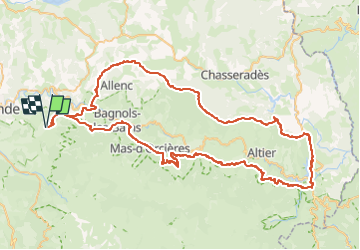
Trail Moto cross of 103 km to be discovered at Occitania, Lozère, Lanuéjols. This trail is proposed by lauz'oustal Restaurant chambres d'hôtes.

Elevation profile

Positioning

Country:
France
Region :
Occitania
Department/Province :
Lozère
Municipality :
Lanuéjols
Location:
Unknown
Start:(UTM)
545005 ; 4927555 (31T) N.

Trails nearby

Trail Walking Badaroux - Pelgeires,le Born la Rouviere  - Photo
Walking
tyntyn

Walking

Medium
Badaroux, Occitania, Lozère, France
12.5 km | 18.1 km-effort
3h 6min
Yes
Trail Walking Sainte-Hélène - mardi - Photo
Walking
olivier78000

Walking

Very easy
Sainte-Hélène, Occitania, Lozère, France
12.9 km | 17.7 km-effort
3h 53min
No
Trail Walking Saint-Étienne-du-Valdonnez - gorges du Bramont - Photo
Walking
thomas.o.vert

Walking

Medium
Saint-Étienne-du-Valdonnez, Occitania, Lozère, France
10 km | 14.8 km-effort
3h 40min
Yes
Trail Walking Lanuéjols - Château de Chapieu - Photo
Walking
jgiraud

Walking

Easy
Lanuéjols, Occitania, Lozère, France
6.6 km | 9.3 km-effort
2h 44min
Yes
Trail Walking Brenoux - langlade /Balduc - Photo
Walking
tyntyn

Walking

Medium
Brenoux, Occitania, Lozère, France
8.8 km | 13.8 km-effort
2h 50min
Yes
Trail Walking Brenoux - Langlade - Photo
Walking
tyntyn

Walking

Easy
Brenoux, Occitania, Lozère, France
12 km | 16.7 km-effort
3h 6min
Yes
Trail Walking Mende - chanteperdrix - Photo
Walking
tyntyn

Walking

Very difficult
Mende, Occitania, Lozère, France
14.6 km | 20 km-effort
3h 24min
Yes
Trail Mountain bike Saint-Bauzile - aerodrome masseguin alle retaur - Photo
Mountain bike
tyntyn

Mountain bike

Medium
Saint-Bauzile, Occitania, Lozère, France
23 km | 29 km-effort
2h 0min
Yes
Trail sport Saint-Bauzile - ITILAR048V508Y7A - Photo
sport
tyntyn

sport

Very easy
Saint-Bauzile, Occitania, Lozère, France
18 km | 24 km-effort
Unknown
No


Close
My subscriptions