Trail Walking Saint-Dalmas-le-Selvage -  Col de la Braïssa  - Photo
 bozo1970
bozo1970

User

© OpenStreetMap contributors
Length
Length
8.9 km
Max alt
Max alt
2606 m
Uphill gradient
Uphill gradient
623 m
Km-Effort
Km-Effort  
17.2 km
Min alt
Min alt
1973 m
Downhill gradient
Downhill gradient
623 m
Boucle
Boucle
Yes
Creation date :
2024-06-20 07:22:14.0
Updated on :
2024-06-21 06:27:54.266

(0 Reviews)

Walking
Walking
3h12
Difficulty : Difficult

Scan this QR Code to open this trail in the SityTrail application

FREE GPS app for hiking

Logo SityTrail SityTrail

IGN / Geographical institutes

Download SityTrail from the App Store Download SityTrail from Google Play

Logo SityTrail SityTrail World

The world is yours!

Download SityTrail from the App Store Download SityTrail from Google Play Download SityTrail on Huawei AppGallery

About

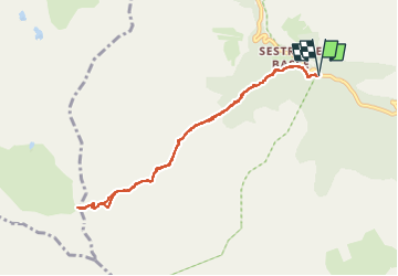
Trail Walking of 8.9 km to be discovered at Provence-Alpes-Côte d'Azur, Maritime Alps, Saint-Dalmas-le-Selvage. This trail is proposed by bozo1970.

Description

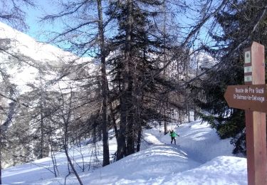
Départ du refuge de Sestrière
Pluie  
Sentier inondé dans le vallon de la Braïsse jusqu'à 2300 m
Progression difficile
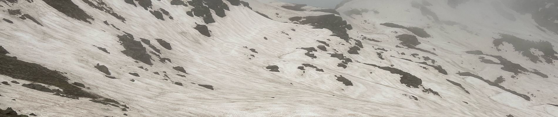
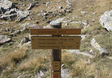
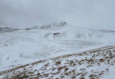
Gros névé sous le col en 1h51' D  627 et 4km400
Très belle vue malgré le ciel bas
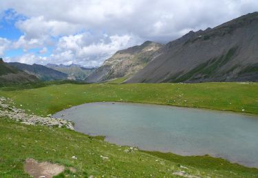
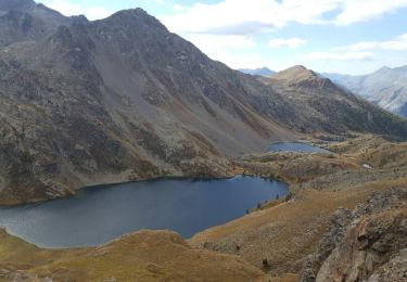
Vallées très ouvertes de tous les côtés
A/R en 3h104 D  635 et 8km700

Elevation profile

Photos

Positioning

Country:
France
Region :
Provence-Alpes-Côte d'Azur
Department/Province :
Maritime Alps
Municipality :
Saint-Dalmas-le-Selvage
Location:
Unknown
Start:(UTM)
326511 ; 4906739 (32T) N.

Trails nearby

Trail On foot Uvernet-Fours - Pointe de Colombart - Photo
On foot
PRO

On foot

Easy
Uvernet-Fours, Provence-Alpes-Côte d'Azur, Alpes-de-Haute-Provence, France
8.1 km | 11.7 km-effort
2h 40min
Yes
Trail On foot Saint-Dalmas-le-Selvage - Col de Gialorgues - Photo
On foot
PRO

On foot

Easy
Saint-Dalmas-le-Selvage, Provence-Alpes-Côte d'Azur, Maritime Alps, France
9.8 km | 17 km-effort
3h 52min
Yes
Trail On foot Saint-Dalmas-le-Selvage - Crête de la Blanche - Photo
On foot
PRO

On foot

Medium
Saint-Dalmas-le-Selvage, Provence-Alpes-Côte d'Azur, Maritime Alps, France
12 km | 20 km-effort
4h 33min
Yes
Trail Walking Saint-Dalmas-le-Selvage - Tête de Pelouse  - Photo
Walking
bozo1970

Walking

Very difficult
Saint-Dalmas-le-Selvage, Provence-Alpes-Côte d'Azur, Maritime Alps, France
12.7 km | 28 km-effort
7h 30min
Yes
Trail Snowshoes Saint-Dalmas-le-Selvage - Col de la Moutière - Photo
Snowshoes
bozo1970

Snowshoes

Medium
Saint-Dalmas-le-Selvage, Provence-Alpes-Côte d'Azur, Maritime Alps, France
17.8 km | 30 km-effort
5h 3min
Yes
Trail Snowshoes Saint-Dalmas-le-Selvage - Tête de Vinaigre  - Photo
Snowshoes
bozo1970

Snowshoes

Medium
Saint-Dalmas-le-Selvage, Provence-Alpes-Côte d'Azur, Maritime Alps, France
10.5 km | 22 km-effort
4h 22min
Yes
Trail Walking Saint-Dalmas-le-Selvage - Sestrieres - col de Braïssa - Photo
Walking
patsure

Walking

Difficult
Saint-Dalmas-le-Selvage, Provence-Alpes-Côte d'Azur, Maritime Alps, France
9.4 km | 17.9 km-effort
3h 12min
Yes
Trail Walking Saint-Dalmas-le-Selvage - Le Castel de la Tour - Photo
Walking
bozo1970

Walking

Very difficult
Saint-Dalmas-le-Selvage, Provence-Alpes-Côte d'Azur, Maritime Alps, France
10.5 km | 23 km-effort
5h 38min
Yes
Trail Walking Saint-Dalmas-le-Selvage - Crête de la Blanche - Photo
Walking
GuyVachet

Walking

Very difficult
Saint-Dalmas-le-Selvage, Provence-Alpes-Côte d'Azur, Maritime Alps, France
18.2 km | 30 km-effort
7h 21min
Yes


Close
My subscriptions