Trail Walking Oberstdorf - Nebelhorn - Photo
 Geert H.
Geert H.

User

© OpenStreetMap contributors
Length
Length
12.6 km
Max alt
Max alt
2210 m
Uphill gradient
Uphill gradient
217 m
Km-Effort
Km-Effort  
20 km
Min alt
Min alt
812 m
Downhill gradient
Downhill gradient
1586 m
Boucle
Boucle
No
Creation date :
2024-06-18 10:43:26.572
Updated on :
2024-06-22 07:46:24.39

(0 Reviews)

Walking
Walking
2h18
Difficulty : Medium

Scan this QR Code to open this trail in the SityTrail application

FREE GPS app for hiking

Logo SityTrail SityTrail

IGN / Geographical institutes

Download SityTrail from the App Store Download SityTrail from Google Play

Logo SityTrail SityTrail World

The world is yours!

Download SityTrail from the App Store Download SityTrail from Google Play Download SityTrail on Huawei AppGallery

About

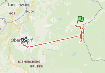
Trail Walking of 12.6 km to be discovered at Bavaria, Landkreis Oberallgäu, Oberstdorf. This trail is proposed by Geert H..

Description

Went up to the top of the Nebelhorn by cable car and came back on foot to the Höfatsblick mountain station. Walke around and back down to Oberstdorf to see a little bit of the town.

Elevation profile

Photos

Positioning

Country:
Germany
Region :
Bavaria
Department/Province :
Landkreis Oberallgäu
Municipality :
Oberstdorf
Location:
Unknown
Start:(UTM)
601282 ; 5252933 (32T) N.

Trails nearby

Trail On foot Oberstdorf - B - Winterwanderung ins Stillachtal - Photo
On foot
GUIDE+

On foot

Easy
Oberstdorf, Bavaria, Landkreis Oberallgäu, Germany
4.4 km | 6.2 km-effort
1h 24min
No
Trail On foot Oberstdorf - D - Gerstruben - ein Bergdorf im Winter - Photo
On foot
GUIDE+

On foot

Easy
Oberstdorf, Bavaria, Landkreis Oberallgäu, Germany
3.2 km | 3.9 km-effort
52min
No
Trail On foot Oberstdorf - O - Winterwanderung ins Oytal - Photo
On foot
GUIDE+

On foot

Easy
Oberstdorf, Bavaria, Landkreis Oberallgäu, Germany
4.9 km | 5.7 km-effort
1h 17min
No
Trail On foot Oberstdorf - G - Winterwanderung zur Gaisalpe - Photo
On foot
GUIDE+

On foot

Easy
Oberstdorf, Bavaria, Landkreis Oberallgäu, Germany
4.6 km | 6.2 km-effort
1h 24min
No
Trail On foot Oberstdorf - Ru - Im Winter zur Schöllanger Burgkirche - Photo
On foot
GUIDE+

On foot

Easy
Oberstdorf, Bavaria, Landkreis Oberallgäu, Germany
3.6 km | 4.4 km-effort
59min
No
Trail On foot Oberstdorf - Hindelanger Klettersteig - Photo
On foot
GUIDE+

On foot

Easy
Oberstdorf, Bavaria, Landkreis Oberallgäu, Germany
6.7 km | 13.1 km-effort
2h 58min
No
Trail On foot Oberstdorf - M - Über den Moorweiher ins Trettachtal - Photo
On foot
GUIDE+

On foot

Easy
Oberstdorf, Bavaria, Landkreis Oberallgäu, Germany
6.7 km | 8.4 km-effort
1h 54min
No
Trail On foot Oberstdorf - H - Vom Schönblick nach Hochleite - Photo
On foot
GUIDE+

On foot

Easy
Oberstdorf, Bavaria, Landkreis Oberallgäu, Germany
9.5 km | 17.2 km-effort
3h 54min
No
Trail Cycle Fischen im Allgäu - f-duitsland-trettachtal-langs-de-iller - Photo
Cycle
gpstracks

Cycle

Very easy
Fischen im Allgäu, Bavaria, Landkreis Oberallgäu, Germany
30 km | 35 km-effort
Unknown
Yes


Close
My subscriptions